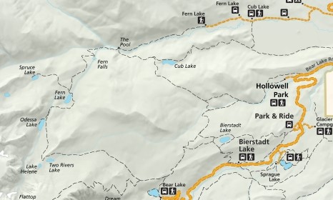
Bear Lake to Fern Lake Trailhead
| Trail Features: | Outstanding Views, Subalpine Lakes, Falls | 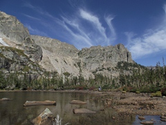 |
|||
| Trail Location: | Bear Lake | ||||
| Roundtrip Length: | 9.2 Miles | ||||
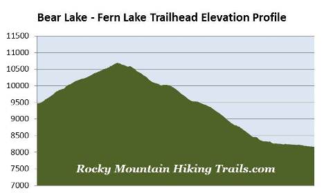
| Trailhead Elevation: | 9475 Feet | ||||
| Total Elevation Gain: | 1230 Feet | ||||
| Avg. Elev Gain / Mile: | 267 Feet | ||||
| Highest Elevation: | 10,697 Feet | ||||
| Trail Difficulty Rating: | 11.66 (strenuous) | ||||
| Parking Lot Latitude | 40.31196 | ||||
| Parking Lot Longitude | -105.64581 | ||||
Trail Description:
As a result of Rocky Mountain National Park's excellent free shuttle system, hikers have the option of taking the spectacular one-way hike from Bear Lake to the Fern Lake Trailhead in Moraine Park. Although you can travel in either direction, the total elevation gain is much lower if you begin your hike from Bear Lake. The Bear Lake Trailhead is located at the end of Bear Lake Road, 9 miles from the turn-off at Highway 36.
From the trailhead hikers will immediately make a right turn onto the Bear Lake Loop Trail. After a short walk along the eastern shore of Bear Lake you'll make another right turn onto the trail that leads towards Odessa Lake and Flattop Mountain. From here the trail passes through a nice aspen grove as it begins ascending the slopes of the Bierstadt Moraine.
Roughly one-half mile from the trailhead you'll reach the trail that leads to Bierstadt Lake and the Mill Creek Basin. Hikers should turn left at this junction to continue towards Odessa Lake. From the junction the route begins heading due west. As it climbs higher you'll enjoy spectacular views of Longs Peak, the Keyboard of the Winds, Pagoda Peak and Chiefs Head Peak looking towards the south.
At just over a mile from the trailhead hikers will reach the Flattop Mountain Trail, which forks off to the left. To continue on towards the Fern Lake Trailhead hikers should proceed straight ahead at this junction.
The first mile above the Flattop Mountain Trail junction is a steady climb through a dense pine forest. The terrain begins to ease a little during the second mile as you ascend the Mill Creek Drainage, the valley between Flattop Mountain and Joe Mills Mountain. Here the trail alternates between forest and open areas that provide excellent views of the surrounding mountains.
 At 2.75 miles hikers will pass the side trail that leads to the Sourdough Backcountry Campsite (one campsite). Just beyond this junction the trail reaches its highest point.
Roughly 3.2 miles from the trailhead hikers will arrive at an unmarked side trail that leads to Lake Helene on your left. Immediately past this junction the main trail makes a sharp turn to the right, and begins descending rapidly. If you've reached this point you've obviously gone too far. It's unclear why the national park doesn't have a trail marker here, but Lake Helene should not be passed. If anything, this is a great place to take a short break.
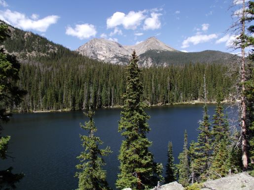
From the unmarked junction hikers will reach Lake Helene by walking a short distance along a narrow and somewhat faint path. From the shore of this beautiful subalpine lake the views are absolutely fantastic. The sentinel dominating the scene from the north shore is 12,129-foot Notchtop Mountain. To the right, looking west-northwest, is 12,331-foot Knobtop Mountain. To the south is 12,324-foot Flattop Mountain, and in between, sitting behind Flattop and Notchtop, is 12,363-foot Ptarmigan Point.
 As already mentioned, just beyond the side path to Lake Helene the main trail makes a sharp turn to the right, and begins heading down into the spectacular Odessa Gorge. Look below the north face of Notchtop Mountain and you'll see Grace Falls dropping more than a hundred feet down the peak's steep slopes.
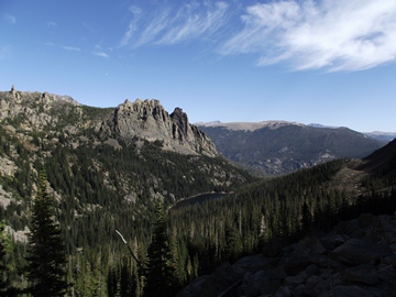
For the next half-mile or so, as you proceed down the western slopes of Joe Mills Mountain, hikers will enjoy spectacular views of Little Matterhorn and The Gable, as well as Odessa Lake sitting more than 500 feet in the valley below. Hikers should note that ice and snow can linger on this section of trail until June, and sometimes even into July. If planning a hike during the early summer time period it's probably a good idea to check with a ranger on trail conditions beforehand.
As you proceed down the rugged gorge the trail actually passes by Odessa Lake. However, at 4.3 miles, you'll reach a short side trail that leads back up to the foot of the lake. This side path also provides access to the Odessa Lake Backcountry Campsite, which includes two individual sites.
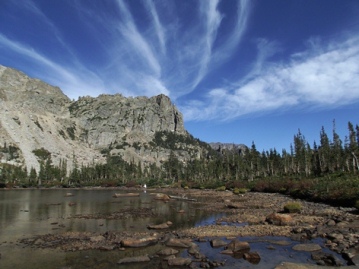
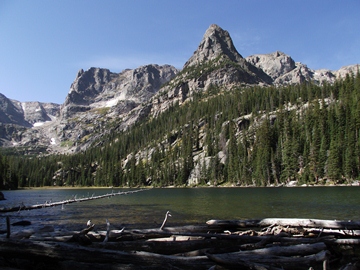 Odessa Lake is another fantastic destination in Rocky Mountain National Park. The views of the surrounding mountains are outstanding. Looking from your left (due south) to right, you'll see 12,324-foot Flattop Mountain, 12,129-foot Notchtop Mountain, 11,586-foot Little Matterhorn, 12,331-foot Knobtop Mountain, 11,939-foot Gabletop Mountain and 11,018-foot The Gable.
From Odessa Lake the one-way hike continues by heading down to its next destination at Fern Lake. Once back on the main route the trail descends fairly rapidly towards the lake. Along this stretch you'll begin passing through areas that were severely burned during the East Troublesome Fire of 2020. This historic fire scorched nearly 29,000 acres within the park boundaries, making it the largest wildfire in Rocky Mountain National Park history.
At roughly 5.1 miles from the trailhead you'll enjoy a great view of Fern Lake from roughly 50 feet above the water. In my opinion this view is arguably more scenic than what's offered from the shore further down the trail. Standing prominently behind the lake from this vantage point is 12,922-foot Stones Peak.
 From the overlook the trail skirts around the east side of the lake, passes the Fern Lake Group Campsite, and then crosses a fairly long footbridge before arriving at the foot of the lake, roughly 5.4 miles from the trailhead. The north shore of Fern Lake offers great views of Notchtop Mountain, Little Matterhorn, Knobtop Mountain and The Gable.
In the early 1900s Dr. William J. Workman began construction on a fishing lodge along the shores of the lake. This would eventually evolve into the Fern Lake Lodge, which would include a dining room, as well as a dormitory and log cabins that could accommodate up to 55 people. Although the lodge ceased most operations in the late 1930s, it continued serving light snacks through the 1950s. During the summer of 1958 the lodge was managed by future folksinger Judy Collins and her husband. In 1976 the National Park Service razed the property and returned the area to its natural state.
After passing the site of the former Fern Lake Backcountry Patrol Cabin, which was built in 1925, but was lost during the East Troublesome Fire, the trail continues marching northward. At roughly 5.5 miles hikers will arrive at the Spruce Lake Trail junction. This pleasant lake can be reached by hiking eight-tenths of a mile up a fairly rugged trail.
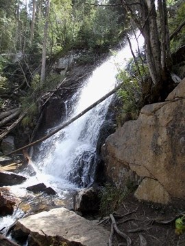
Beyond the Spruce Lake Trail junction the trail becomes a relentless descent, and drops more than 650 feet in one mile as it makes its way towards Fern Falls. At roughly 6.6 miles hikers will reach Fern Falls, a beautiful 60-foot waterfall that plunges down Fern Creek.
 From here the trail resumes its rapid descent towards the Big Thompson River.
At just over 7.3 miles hikers will pass the side trail that leads to the Old Forest Inn Backcountry Campsite (two sites). Just beyond the campsite, at 7.5 miles, is the Cub Lake Trail junction. This also marks the spot where Fern Creek meets the Big Thompson River. This confluence forms the turbulent waters known as The Pool, and is a popular area for picnics and fishing.
Located near The Pool is the former site of the Forest Inn. Established in 1917, the Forest Inn featured a lodge, dining room, lounge, and several cabins throughout its lifespan. The resort was sold to the National Park Service in 1952, and was razed in 1959.
Much of the area surrounding The Pool was scorched during the Fern Lake Fire in 2012. The wildfire burned roughly 3500 acres in the lower Forest Canyon, Cub Lake and Moraine Park areas, and was the largest fire in park history up to that point.
From The Pool the trail follows the Big Thompson River all the way down to the Fern Lake Trailhead. At roughly 8 miles hikers will pass through Arch Rocks, a couple of house-sized rocks that presumably landed on this spot when a large boulder fell from the cliffs above and split apart. From Arch Rocks the Fern Lake Trail alternates between forest and a few open areas that provide some pretty good views of the Big Thompson Valley. Along the way you'll pass through a mixed forest of aspens, lodgepole pine, ponderosa pine, cottonwoods and willows, as well as a variety of wildflowers in the spring and summer.
At 9.2 miles hikers will finally arrive at the Fern Lake Trailhead. If you don’t have a second car in your party, and are using the park shuttle system, you'll have to walk another eight-tenths of a mile along the dirt road to reach the Fern Lake shuttle stop.