Bierstadt Lake (via Bear Lake Trailhead)
| Trail Features: | Scenic Lake Views, Fall Aspens | 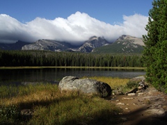 |
|||
| Trail Location: | Bear Lake Trailhead | ||||
| Roundtrip Length: | 4.4 Miles | ||||
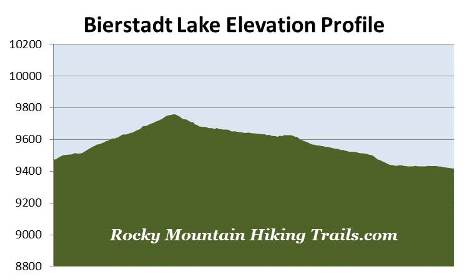
| Trailhead Elevation: | 9475 Feet | ||||
| Total Elevation Gain: | 630 Feet | ||||
| Avg. Elev Gain / Mile: | 286 Feet | ||||
| Highest Elevation: | 9760 Feet | ||||
| Trail Difficulty Rating: | 5.66 (moderate) | ||||
| Parking Lot Latitude | 40.3538 | ||||
| Parking Lot Longitude | -105.6979 | ||||
Trail Description:
Hikers have several options for reaching Bierstadt Lake in Rocky Mountain National Park. One of the easiest routes is from Bear Lake. The Bear Lake Trailhead is located at the end of Bear Lake Road, 9 miles from the turn-off at Highway 36. Due to the extreme popularity of the area you may want to consider using the free park shuttle to reach the trailhead during peak tourist season.
 I also recommend starting your hike first thing in the morning, especially if you wish to avoid the crowds at this extremely popular destination. Starting early will also provide you with an opportunity to possibly go home with some great photos of Hallett Peak reflecting off Bear Lake during calm weather.
From the trailhead hikers will immediately make a right turn onto the Bear Lake Loop Trail. After a short walk along the eastern shore of the lake you'll make another right turn onto the trail that leads towards Odessa Lake. From here the trail passes through a nice aspen grove as it begins ascending the slopes of the Bierstadt Moraine.
Roughly one-half mile from the trailhead you'll arrive at the trail that leads to Bierstadt Lake and the Mill Creek Basin. Hikers should turn right at this junction to continue on towards Bierstadt Lake. A turn to the left will lead you up to Lake Helene and Odessa Lake.
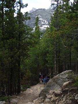
At roughly two-thirds of a mile hikers will reach the top of the Bierstadt Moraine. Near the top you'll have a few glimpses of Hallett Peak and Flattop Mountain through the trees. The trail now begins a slow descent towards Bierstadt Lake. This portion of the hike passes through a pleasant evergreen forest. There are a few sections of the trail that are boulder strewn, but for the most part it travels across fairly easy terrain.
 At roughly 1.2 miles hikers will arrive at the Mill Creek Trail junction. The trail to the left leads to the Mill Creek Basin and Hollowell Park, while the trail to the right continues on towards Bierstadt Lake.
At roughly 1.8 miles you'll reach the loop trail around Bierstadt Lake. The best views are from the north side of the lake, therefore hikers should turn left at this junction.
The trail circling around the lake passes through a very pleasant forest of spruce, fir and lodgepole pine. In some places, however, you'll notice clusters of dead and dying trees, a result of the mountain pine beetle infestation that's impacted forests throughout the west. Keep an eye out for wildlife as you pass through this area as well.
Shortly after turning onto the loop trail you'll pass another spur trail that leads to the Mill Creek Basin area. Continue on the loop by staying to the right here.
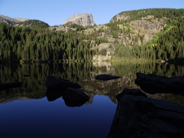
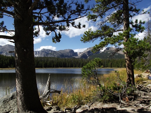
At almost 2.2 miles hikers will reach the side trail that leads to Bierstadt Lake. A short hike of roughly 100 yards will take you to the northeastern shore of this beautiful subalpine lake.
Bierstadt Lake is surrounded by a thick pine forest, and is ringed by sedges that give it a very serene appearance. From this vantage point you'll have stunning panoramic views of the mountains along the Continental Divide, including, from left to right: Longs Peak, Chiefs Head Peak, McHenrys Peak, Powell Peak, Taylor Peak, Otis Peak, Hallett Peak and Flattop Mountain.
The lake is named after renowned western landscape painter Albert Bierstadt (1830-1902). He was brought to the area in 1876 by the Earl of Dunraven, a wealthy Irish aristocratic that nearly succeeded in owning all of Estes Park. The Earl commissioned Bierstadt to paint a large landscape of Estes Park and Longs Peak. Upon completion the Earl sent the painting to Europe to adorn the walls of the Dunraven Castle in South Wales. Today the painting is back in Colorado, and is owned by the Denver Public Library.
After soaking in the magnificent views from the lake, this out-and-back hike continues by turning around and retracing your steps back to Bear Lake. However, as a result of Rocky Mountain National Park's excellent shuttle system, hikers will have the option of making this into a one-way hike by circling around to the opposite end of the lake, and then heading down towards the Bierstadt Lake Trailhead on Bear Lake Road. From this trailhead you'll be able to return back to Bear Lake via the shuttle. Although you can travel in either direction, the total elevation gain is much lower if you begin your hike from Bear Lake. You can click here for more information on the hike from the Bierstadt Lake Trailhead.