Bierstadt Lake Loop
| Trail Features: | Scenic Lake Views, Fall Aspens, Forest | 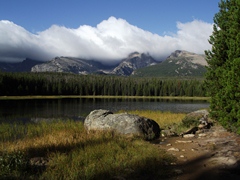 |
|||
| Trail Location: | Bierstadt Lake | ||||
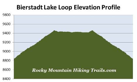
| Roundtrip Length: | 3.2 Miles | ||||
| Trailhead Elevation: | 8840 Feet | ||||
| Total Elevation Gain: | 725 Feet | ||||
| Avg. Elev Gain / Mile: | 453 Feet | ||||
| Highest Elevation: | 9466 Feet | ||||
| Trail Difficulty Rating: | 4.65 (easy) | ||||
| Parking Lot Latitude | 40.32063 | ||||
| Parking Lot Longitude | -105.62403 | ||||
Trail Description:
The Bierstadt Lake Loop in Rocky Mountain National Park begins from the Bierstadt Lake Trailhead, located on Bear Lake Road roughly 6.5 miles from the turn-off at Highway 36. Due to the extreme popularity of the Bear Lake Road area you may want to consider using the free park shuttle to reach the trailhead during peak tourist season.
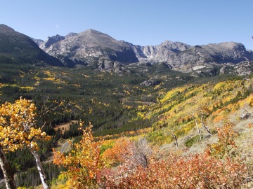 From Bear Lake Road the trail steadily climbs more than 600 feet along a series of switchbacks to reach the top of the Bierstadt Moraine. Along the way it passes through stands of lodgepole pines and aspens. As the trail climbs higher spectacular views of the mountains along the Continental Divide begin to open up.
Geologically speaking, Bierstadt Moraine is a lateral moraine leftover from the ice age when glaciers sculpted the landscape. Moraines are essentially piles of stones, gravel and soil left behind by a glacier.
Shortly after cresting the top of the moraine, roughly one mile from the trailhead, hikers will reach the Bierstadt Lake Loop Trail junction. Although you can proceed in either direction, this description follows the loop hike in a clockwise direction.
 The trail circling the lake passes through a very pleasant forest of spruce, fir and lodgepole pine. In some places, however, you'll notice clusters of dead and dying trees, a result of the mountain pine beetle infestation that has impacted forests throughout the west. Keep an eye out for wildlife as you pass through this area as well.
Roughly 1.2 miles from the trailhead you'll reach a path that leads to Bear Lake, and shortly afterwards, will pass the junction for the spur trail that leads to the Mill Creek Basin area.
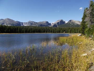
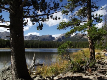
At just over 1.5 miles hikers will reach the side trail that leads to Bierstadt Lake. A short hike of roughly 100 yards will take you to the northeastern shore of this beautiful subalpine lake.
Bierstadt Lake is surrounded by a thick pine forest, and is ringed by sedges that give it a very serene appearance. From this vantage point you'll have stunning panoramic views of the mountains along the Continental Divide, including, from left to right: Longs Peak, Chiefs Head Peak, McHenrys Peak, Powell Peak, Taylor Peak, Otis Peak, Hallett Peak and Flattop Mountain.
 The lake is named after renowned western landscape painter Albert Bierstadt (1830-1902). He was brought to the area in 1876 by the Earl of Dunraven, a wealthy Irish aristocratic that nearly succeeded in owning all of Estes Park. The Earl commissioned Bierstadt to paint a large landscape of Estes Park and Longs Peak. Upon completion the Earl sent the painting to Europe to adorn the walls of Dunraven Castle in South Wales. Today the painting is back in Colorado, and is owned by the Denver Public Library.
After soaking in the views from the lake, the hike continues by retracing your steps back out to the main trail, and turning right towards the south side of the lake. In two-tenths of a mile you’ll pass a side trail that leads to the shuttle bus parking area. At roughly 2.1 miles the trail reaches a horse corral and another access point to the lake. Although there are some nice views from this vantage point, the views are much better from the opposite end of the lake. A short distance from the corral is the end of the loop trail. To return back to the trailhead, hikers should turn left at this junction.