Big Meadows
| Trail Features: | Scenic Views, Meadows, Wildflowers | 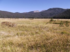 |
|||
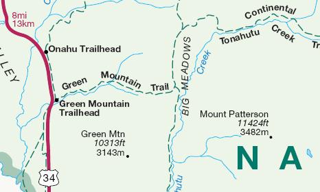
| Trail Location: | Green Mountain Trailhead | ||||
| Roundtrip Length: | 3.6 Miles | ||||
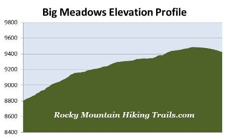
| Trailhead Elevation: | 8805 Feet | ||||
| Total Elevation Gain: | 740 Feet | ||||
| Avg. Elev Gain / Mile: | 411 Feet | ||||
| Highest Elevation: | 9485 Feet | ||||
| Trail Difficulty Rating: | 5.08 (moderate) | ||||
| Parking Lot Latitude | 40.30738 | ||||
| Parking Lot Longitude | -105.84109 | ||||
Trail Description:
The hike to Big Meadows in Rocky Mountain National Park begins from the Green Mountain Trailhead, located 2.5 miles north of the Grand Lake Entrance.
From the parking area the Green Mountain Trail begins climbing through a lush conifer forest. The climb is steady and moderate, but graduates to more gentle grades after the first half-mile, with a few short steeper inclines thrown in every now and then. As the trail levels out you'll begin passing a couple of small meadows along the way. Keep an eye out for moose and elk foraging in these fields as you pass near them.
 The Green Mountain Trail is part of the Continental Divide National Scenic Trail, a 3100-mile footpath that traverses the Rocky Mountains from Mexico to Canada. The trail enters the park near Lake Granby and follows the western edge of the park up to Grand Lake. From there the CDT makes a semi-loop up to Flattop Mountain via the North Inlet Trail, before descending back down the Tonahutu Creek Trail and exiting the park by way of the Green Mountain Trail.
Roughly 1.7 miles from the trailhead you'll pass a side trail that leads to the Green Mountain Backcountry Campsite (one site).
Less than one-tenth of a mile later you'll reach the Tonahutu Creek Trail junction. Hikers can visit Granite Falls by traveling another 3.6 miles northbound on this trail. One-tenth of a mile to the south begins a series of campsites, including the Big Meadows Backcountry Group Site, the South Meadows Backcountry Campsite (one campsite), and the Paint Brush Backcountry Campsite, which also has only one campsite.
 Once at the junction look for a horse hitch sign. Continue down the hill to the hitch where you'll find a couple of faint social trails that lead out to the meadow. There are several large boulders near the edge of the meadow that make for a great resting spot, as well as an excellent place to soak in the magnificent views.
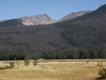
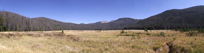
Big Meadows is surrounded by 12,216-foot Nakai Peak towards the northeast, 12,274-foot Snowdrift Peak towards the east, and 11,424-foot Mt. Patterson towards the southeast. The two mountains just behind Snowdrift are 12,331-foot Knobtop Mountain and 12,129-foot Notchtop Mountain.
Big Meadows also happens to be the largest montane meadow in the park, and offers ideal habitat for deer, elk and moose. The best time to possibly see one or more of these ungulates is in the early morning or during the later evening hours.
If you look closely you'll likely notice a lot of dead trees in the mountains surrounding the meadow, a result of the mountain pine beetle infestation that's impacted forests throughout the west. I would estimate that at least 80% of the trees visible from the field are already dead.
Indeed, all those dead trees have reaped their potential for destruction. On June 10, 2013 a lightning strike started a wildfire just to the northeast of Big Meadows - along the southern slopes of Nakai Peak. Seven days later, after burning 617 acres, the Big Meadows Fire was considered to be 95% contained. During that week the fire forced the temporary closure of seven trails in the area, including the Green Mountain Trail. The presence of so many beetle-killed trees allowed the fire to spread quickly, and posed the risk for extreme growth potential during the blaze.
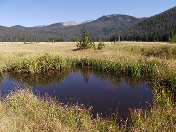
For additional views of Big Meadows and the surrounding mountains you can continue northbound along the Tonahutu Creek Trail for roughly 1.2 miles as it skirts along the western and northern edges of the meadow. The trail offers several good vantage points, as well as access to the meadow. You should note that the edge of the meadow can be a bit marshy, especially in the spring. Also, only two-tenths of a mile up the trail are the remnants of an old homesteader's cabin from the early 1900s.
Flowing along the eastern edge of Big Meadows is the Tonahutu Creek. Tonahutu, by the way, happens to be the Arapaho word for "big meadows".