Cascade Falls
| Trail Features: | Waterfalls, Wildlife, Wildflowers | 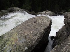 |
|||
| Trail Location: | North Inlet Trailhead | ||||
| Roundtrip Length: | 6.8 Miles | ||||
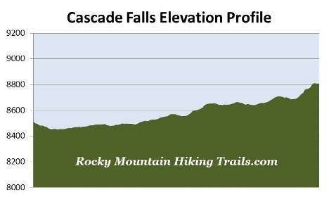
| Trailhead Elevation: | 8510 Feet | ||||
| Total Elevation Gain: | 430 Feet | ||||
| Avg. Elev Gain / Mile: | 126 Feet | ||||
| Highest Elevation: | 8811 Feet | ||||
| Trail Difficulty Rating: | 7.66 (moderate) | ||||
| Parking Lot Latitude | 40.25658 | ||||
| Parking Lot Longitude | -105.81459 | ||||
Trail Description:
The hike to Cascade Falls begins from the North Inlet Trailhead near the town of Grand Lake on the west side of Rocky Mountain National Park. After turning into the Grand Lake area from Hwy 34 / Trail Ridge Road, drive 0.3 miles on West Portal Road until you reach a split in the road. Stay left at the junction and continue on West Portal Road for another 0.8 miles to reach the turn-off for the Tonahutu/North Inlet Trailheads. Turn left and drive 0.2 miles along the dirt road to a spilt in the road, and then turn right to reach the North Inlet Trailhead. The main parking area is just beyond the split. Additional parking is also available just beyond the trailhead.
The first 1.2 miles of the North Inlet Trail follows along an old dirt road. Hikers should note that much of this portion of the trail also travels through private land.
 The North Inlet Trail is part of the Continental Divide National Scenic Trail, a 3100-mile footpath that traverses the Rocky Mountains from Mexico to Canada. The trail enters the park near Lake Granby and follows the western edge of the park up to Grand Lake. From there the CDT makes a semi-loop up to Flattop Mountain via the North Inlet Trail, before descending back down the Tonahutu Creek Trail and exiting the park via the Green Mountain Trail.
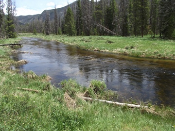
At just over eight-tenths of a mile from the trailhead hikers will reach the North Inlet Creek. This also marks the western end of Summerland Park, a fairly large montane meadow. For the most part the trail doesn't actually pass through Summerland Park, but rather skirts around its northern edge. This section of the trail is an excellent place to spot wildlife. We saw a moose, three deer, as well as several hummingbirds and woodpeckers. We also saw what appears to have been a Williamson's Sapsucker that was feeding its young in the cavity of an aspen tree. Elk are also frequently spotted in this area as well.
At roughly 1.2 miles you'll reach a private summer cabin. Just beyond the cabin is the Summerland Park Group Campsite. This also marks the spot where the dirt road turns into a regular trail.
At roughly 1.7 miles hikers will pass the side trail that leads to the Summerland Park Backcountry Campsite, and at almost 3 miles, will pass the Twinberry Backcountry Campsite.
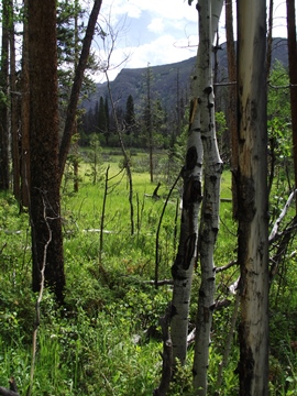
As you get closer to Cascade Falls the terrain becomes increasingly lusher, while the evergreen trees appear to grow much taller. You may also notice that the canyon the North Inlet flows through begins to narrow as well.
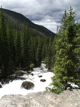
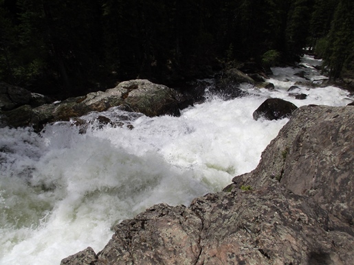
At almost 3.4 miles hikers will reach a split in the trail. The trail to the left is for horses, while the trail to the right leads directly to Cascade Falls. Hikers will have the opportunity to view the falls from below, but the views from above are much better. There's a little bit of scrambling involved to get to the best views for both observation points, but neither is a big issue. However, it is extremely important to be very careful around the falls. One slip into the rushing drink would mean instant death.
Cascade Falls is a spectacular, multi-tiered cascade that drops roughly 40 or 50 feet through a narrow granite chute.
Just beyond the waterfall is a large meadow, which is another good place to spot moose and elk. Hikers may also want to note that mosquitoes can be quite thick in the area surrounding the falls.