

Devils Causeway
| Trail Features: | Outstanding views | 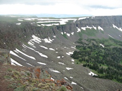 |
|||
| Trail Location: | Stillwater Reservoir | ||||
| Roundtrip Length: | 6.0 Miles | ||||
| Trailhead Elevation: | 10,280 Feet | ||||
| Total Elevation Gain: | 1550 Feet | ||||
| Avg. Elev Gain / Mile: | 517 Feet | ||||
| Highest Elevation: | 11,800 Feet | ||||
| Trail Difficulty Rating: | 9.10 (moderate) | ||||
| Parking Lot Latitude | 40.02155 | ||||
| Parking Lot Longitude | -107.12981 | ||||
Trail Description:
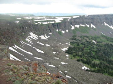
The Devil's Causeway, a narrow strip of land in the heart of the Flat Tops Wilderness Area, is notorious for causing sheer terror, or awe and thrill, for those who dare to cross it. This "land bridge" is roughly 50 feet in length, and narrows to as little as 3 feet in width. On both sides of the rough and rugged trail (terrain is the more proper term) are 60-80 foot cliffs, with steep talus slopes dropping another 600-800 feet into the drainages below. Whether you consider it frightening, or thrilling, the Devil's Causeway offers hikers one of the most spectacular views in the Flat Tops Wilderness Area. Encompassing more than 235,000 acres, the Flat Tops are the second largest U.S. Wilderness Area in the state of Colorado.
 The easiest hike to the Devil's Causeway is from the Stillwater Reservoir. To reach the trailhead turn westbound onto County Road 7 off of Highway 131 in the town of Yampa, roughly halfway between
Wolcott and Steamboat Springs. You'll follow CR 7 for about 7 miles, and then will drive another 9 miles on Forest Service Road 900 (a well maintained dirt road in the Routt National Forest) to the parking area on the north side of the reservoir.
The easiest hike to the Devil's Causeway is from the Stillwater Reservoir. To reach the trailhead turn westbound onto County Road 7 off of Highway 131 in the town of Yampa, roughly halfway between
Wolcott and Steamboat Springs. You'll follow CR 7 for about 7 miles, and then will drive another 9 miles on Forest Service Road 900 (a well maintained dirt road in the Routt National Forest) to the parking area on the north side of the reservoir.
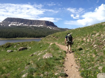
From the trailhead hikers will proceed along the East Fork Trail (1119) as it skirts around the north side of the reservoir. At eight-tenths of a mile from the trailhead you'll arrive at the Bear River Trail (1120) junction. Stay to the right and continue along the East Fork Trail to proceed up to the Devil's Causeway. A short distance beyond the junction you'll cross the Flat Tops Wilderness Area boundary.
At roughly 1.8 miles the trail passes Little Causeway Lake, which will be on your left. Looking straight ahead at this point will be the Devil's Causeway. Towards the left, looking due west, is the Chinese Wall. The easy part of the hike is now over, and the real climbing is about to begin. Over the course of the next 1.2 miles you'll climb roughly one thousand feet - while crossing talus slopes - in order to reach the Devil's Causeway ridgeline.
At 2.9 miles hikers will finally reach the divide between the Bear River and East Fork watersheds. Turn left onto the side trail here to make the short, but steep ascent up to the Causeway.
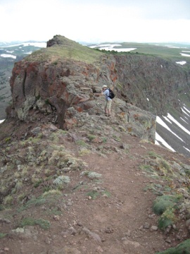 The Devil's Causeway sits at an elevation
of roughly 11,800 feet. Unfortunately (or fortunately), I didn't get a chance to walk all the way across this natural land bridge. Just seconds after shooting a few pictures it began to rain, forcing us to turn around. Our group had to hightail it down the mountain after we began hearing thunder almost directly above us.
The Devil's Causeway sits at an elevation
of roughly 11,800 feet. Unfortunately (or fortunately), I didn't get a chance to walk all the way across this natural land bridge. Just seconds after shooting a few pictures it began to rain, forcing us to turn around. Our group had to hightail it down the mountain after we began hearing thunder almost directly above us.
You should note that crossing the Causeway is extremely dangerous. Many people are reduced to crossing it on their hands and knees, or even on their butts. If you have an extreme fear of heights, or if it's wet, or if there are high winds, or bad weather is moving in, DO NOT attempt to cross the Causeway.
If you're able to make it across the Causeway you'll have the option of creating a spectacular one-way loop hike. The Devil's Causeway Trail will dead-end into the Chinese Wall Trail (1803) in about one-and-a-quarter miles. From this junction you'll turn left onto the Chinese Wall Trail and will hike roughly 2.4 miles to reach the Bear River Trail (1120) where you'll make another left turn. From here hikers will travel another 4 miles or so back to the Stillwater Reservoir. In all, this loop hike is roughly 10.5 miles in total length.