Estes Cone (via Lily Lake)
| Trail Features: | Panoramic Views | 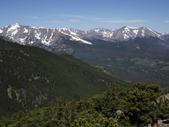 |
|||
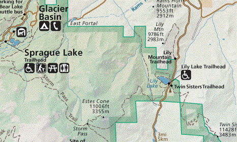
| Trail Location: | Lily Lake | ||||
| Roundtrip Length: | 7.5 Miles | ||||
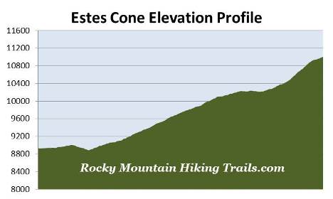
| Trailhead Elevation: | 8930 Feet | ||||
| Total Elevation Gain: | 2275 Feet | ||||
| Avg. Elev Gain / Mile: | 607 Feet | ||||
| Highest Elevation: | 11,006 Feet | ||||
| Trail Difficulty Rating: | 12.05 (strenuous) | ||||
| Parking Lot Latitude | 40.30641 | ||||
| Parking Lot Longitude | -105.53803 | ||||
Trail Description:
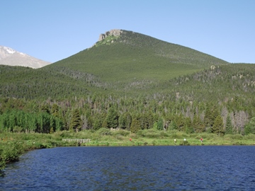
This hike to Estes Cone in Rocky Mountain National Park begins from the Lily Lake parking area, located 6.3 miles south of Estes Park on Colorado Highway 7. You can park in the Lily Lake parking area, or across the highway at the old Lily Lake Visitor Center (now closed). The Storm Pass Trailhead is located on the south end of the Lily Lake parking area.
 The trail begins by following a park service road. At just under two-tenths of a mile both the trail and the road make a turn towards the left, while the trail to the right circles back to Lily Lake. Just beyond this junction the Storm Pass Trail officially splits-off from the dirt road. Look for a posted sign indicating that hikers should turn right to continue on towards Estes Cone.
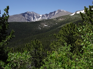
During the early portions of the hike you'll be treated to sporadic views of Longs Peak, as well as your ultimate destination.
Although the name might give you the impression, Estes Cone is not the result of an ancient volcano. Rather, the cone-shaped mountain was formed by natural erosion, mainly due to its relative isolation from the surrounding mountains.
After roughly four-tenths of a mile the trail finally enters the cover of the forest, and more or less remains there until just below the summit. Occasionally you'll have some views of the surrounding mountains peeking out through the trees.
At two-thirds of a mile from the trailhead you'll reach an intersection with a trail that leads to private property. Hikers should continue over the footbridge to proceed towards Estes Cone.
 Once past the footbridge the trail begins to make a steady climb up the eastern slopes of Estes Cone. The next 1.8 miles will be a fairly steep climb. However, at roughly 10,100 feet, the terrain moderates considerably.
At almost 3.1 miles hikers will arrive at the Estes Cone Trail junction. The Eugenia Mine Trail also forks in from the left here, and provides hikers with the option of reaching Estes Cone from the Longs Peak Trailhead. From this point the Storm Pass Trail continues on for another 4.1 miles towards Bear Lake Road. Hikers should turn right onto the Estes Cone Trail to continue towards the summit. Although there aren't any views at the junction, you will have the opportunity to catch some pretty good views of Mount Meeker and Longs Peak just before reaching the junction.
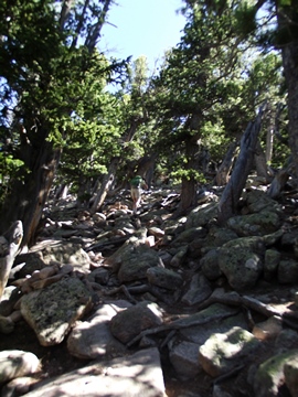
As you might expect, the Estes Cone Trail becomes quite steep, gaining almost 800 feet in just two-thirds of a mile. Hikers should note that there are several sections where the path is faint, and a little hard to read (see photo below on the left). However, if you pay close attention it shouldn't be a problem. There are several cairns along the rugged route to help guide the way.
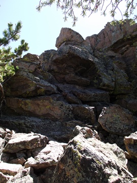
At roughly 3.7 miles hikers will finally reach the base of the summit. The official trail continues by following the rock wall for about a hundred feet towards the right. We chose an easier route that leads directly from the point where the trail reaches the summit wall (see photo above on the right). Although it wasn't quite the very top of the mountain, this perch still provided outstanding panoramic views. We felt this option was a little safer, and a little more in-line with our pay grade! It's also possible to reach the summit from this point, but there's still a bit of scrambling involved. Either way, caution is needed while ascending the rock wall.
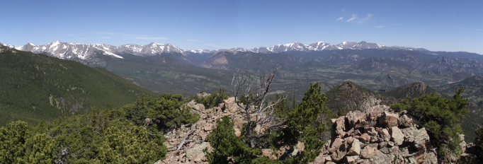
From this rock outcropping hikers will enjoy outstanding panoramic views of Mount Meeker, Longs Peak, Hallett Peak, the mountains along the Continental Divide and in the Mummy Range, as well as much of the Estes Park area.