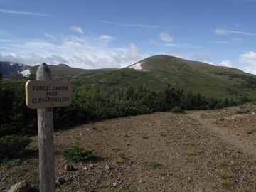
Forest Canyon Pass
| Trail Features: | Panoramic Views, Wildflowers | 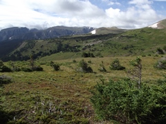 |
|||
| Trail Location: | Milner Pass | ||||
| Roundtrip Length: | 4.8 Miles | ||||
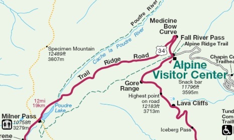
| Trailhead Elevation: | 10,759 Feet | ||||
| Total Elevation Gain: | 600 Feet | ||||
| Avg. Elev Gain / Mile: | 250 Feet | ||||
| Highest Elevation: | 11,320 Feet | ||||
| Trail Difficulty Rating: | 6.00 (moderate) | ||||
| Parking Lot Latitude | 40.4203 | ||||
| Parking Lot Longitude | -105.8114 | ||||
Trail Description:
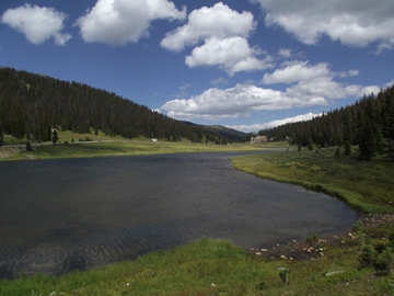
This hike to Forest Canyon Pass begins from the Poudre Lake Trailhead at Milner Pass, located 15.7 miles north of the Grand Lake Entrance, and 4.2 miles south of the Alpine Visitor Center.
 The trail starts off by circling around the southern end of Poudre Lake. Hikers will follow the old Ute Trail all the way up to Forest Canyon Pass. From the pass the trail continues up to the Alpine Visitor Center. According to Rocky Mountain National Park: A History, the Ute Indians likely traveled across the future national park using several east-west routes, such as Forest Canyon, Flattop Mountain, Fall River and Trail Ridge, in order to reach their traditional hunting grounds on the Great Plains.
Once past Poudre Lake the trail begins climbing through a lush subalpine forest. At just over six-tenths of a mile from the trailhead you'll arrive at the Mt. Ida Trail junction. At this point you will have already climbed more than 300 feet. To continue towards Forest Canyon Pass hikers should turn left at this junction.
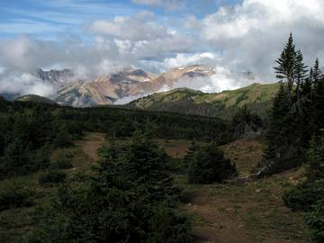 Once past the Mt. Ida Trail junction the grade moderates considerably. Hikers will also have some good views of Specimen Mountain towards the north, as well as the Never Summer Mountains as they begin to emerge above the trees towards the west.
As the trail proceeds it passes through several small meadows. Even during our mid-August hike we still saw quite a few wildflowers.
At almost 1.7 miles the trail emerges into the open where you'll enjoy much more expansive views. If you look straight ahead - on the mountain towards the northeast - you'll likely notice a few vehicles traveling along Trail Ridge Road.
After one last short climb hikers will finally arrive at Forest Canyon Pass. From this vantage point, at an elevation of 11,320 feet, you'll have outstanding panoramic views of Forest Canyon, Terra Tomah Mountain, Mt. Julian and Mt. Ida towards the southeast and the south. You'll also have a nice view of Marmot Point above Trail Ridge Road, as well.
 From the pass hikers will have the option of continuing up to the Alpine Visitor Center, which is another 2.1 miles away from this point. If you have two vehicles in your party you could also do a one-way hike. Preferably, it's best to start from the visitor center so that you can walk downhill for most of the route.
Hikers should always be aware of lightning risk while hiking in the Rocky Mountains, especially at higher elevations. As a general rule of thumb you should plan to be off the summit before noon in order to avoid the notorious afternoon thunderstorms that frequent the mountains during the summer months. Hikers should also be prepared for extreme sun exposure, wind, cool temperatures, and rapidly changing weather conditions while on the trail. Make sure you have the proper gear with you, and know what safety precautions you need to consider beforehand.