
Green Mountain-Onahu Creek Loop
| Trail Features: | Scenic Views, Meadows, Wildflowers | 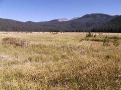 |
|||
| Trail Location: | Green Mountain Trailhead | ||||
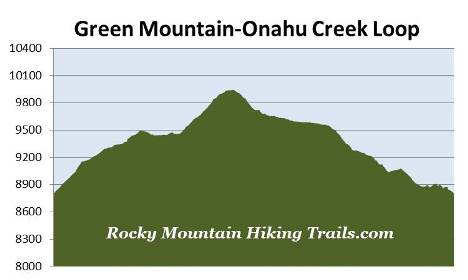
| Roundtrip Length: | 7.5 Miles | ||||
| Trailhead Elevation: | 8805 Feet | ||||
| Total Elevation Gain: | 1300 Feet | ||||
| Avg. Elev Gain / Mile: | 347 Feet | ||||
| Highest Elevation: | 9945 Feet | ||||
| Trail Difficulty Rating: | 10.10 (strenuous) | ||||
| Parking Lot Latitude | 40.30738 | ||||
| Parking Lot Longitude | -105.84109 | ||||
Trail Description:
The Green Mountain-Onahu Creek Loop hike begins from the Green Mountain Trailhead, located 2.5 miles north of the Grand Lake Entrance. You'll also have the option of starting this hike from the Onahu Creek Trailhead. However, this description follows the loop in a counter-clockwise direction starting from the Green Mountain Trailhead.
From the parking area the Green Mountain Trail begins climbing through a lush conifer forest. The climb is steady and moderate, but graduates to more gentle grades after the first half-mile, with a few short steeper inclines thrown in every now and then. As the trail levels out you'll begin passing a couple of small meadows along the way. Keep an eye out for moose and elk foraging in these fields as you pass near them.
 At roughly 1.7 miles from the trailhead you'll pass a side trail that leads to the Green Mountain Backcountry Campsite. Less than a tenth-of-a-mile later you'll arrive at the Tonahutu Creek Trail junction. At the junction look for a horse hitch sign, and then proceed down the hill towards the hitch where you'll find a couple of faint social trails that lead out towards the meadow. There are a couple of large boulders near the edge of the meadow that make for a great resting spot, as well as an excellent place to soak in the views.
Big Meadows is the largest montane meadow in the park, and offers ideal habitat for deer, elk and moose. The best time to possibly see any of these ungulates is in the early morning or during the later evening hours.
The meadow is surrounded by 12,216-foot Nakai Peak towards the northeast, 12,274-foot Snowdrift Peak towards the east, and 11,424-foot Mt. Patterson towards the southeast. The two peaks behind Snowdrift are 12,331-foot Knobtop Mountain and 12,129-foot Notchtop Mountain.
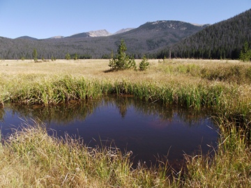
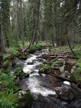
Flowing along the eastern edge of Big Meadows is the Tonahutu Creek. Tonahutu, by the way, is the Arapaho word for "big meadows".
If you look closely you'll notice a lot of dead trees in the mountains surrounding the meadow, a result of the mountain pine beetle infestation that's impacted forests throughout the west. I would estimate that at least 80% of the trees visible from the field are already dead.
Indeed, all those dead trees reaped their potential for destruction. On June 10, 2013 a lightning strike started a wildfire just to the northeast of Big Meadows - along the southern slopes of Nakai Peak. Seven days later, after burning 617 acres, the Big Meadows Fire was considered to be 95% contained. During that week the fire forced the temporary closure of seven trails in the area, including the Green Mountain, Onahu Creek, and Tonahutu Creek Trails. The presence of so many beetle-killed trees allowed the fire to spread quickly, and posed the problem of extreme growth potential during the blaze.
 After viewing Big Meadows hikers should return back to the main trail and turn right to begin heading northbound on the Tonahutu Creek Trail. From the junction the trail skirts around the western edges of the meadow. The trail offers several additional vantage points, as well as access to the meadow. You may want to note, however, that the edge of the meadow can be quite marshy, especially during the spring months.
Both the Green Mountain and Tonahutu Creek Trails are part of the Continental Divide National Scenic Trail, a 3100-mile footpath that traverses the Rocky Mountains from Mexico to Canada. The trail enters the park near Lake Granby and follows the western edge of the park up to Grand Lake. From there the CDT makes a semi-loop up to Flattop Mountain via the North Inlet Trail, before descending back down the Tonahutu Creek Trail and exiting the park by way of the Green Mountain Trail.
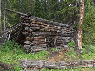
At roughly 2 miles hikers will reach the remnants of an old homesteader's cabin from the early 1900s. Unfortunately the cabin is in very poor condition. Both the roof and the back wall have collapsed.
 At almost 2.4 miles you'll arrive at the Onahu Creek Trail junction. The Tonahutu Creek Trail branches off to the right, and leads towards Granite Falls and Flattop Mountain. To continue on the loop back to Trail Ridge Road, hikers should turn left onto the Onahu Creek Trail.
From the junction the trail climbs almost 450 feet over the course of the next three-quarters of a mile. This section of trail passes through an area dominated by dead trees, a result of the pine beetle infestation. Although many are already lying on the ground, many trees are still standing. During high wind events proceeding any further along this trail may not be a safe option. It may be better to just turnaround and return back to the Green Mountain Trailhead.
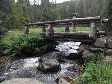
From the top of the ridge the trail makes a rapid descent towards Long Meadows. At roughly 4 miles you'll arrive at the Long Meadows Trail junction. To continue on the loop hikers should proceed straight ahead at this junction. Almost immediately you'll cross over Onahu Creek. On the other side is the Onahu Bridge Backcountry Campsite, and in another tenth-of-a-mile you'll pass the Upper Onahu Backcountry Campsite.
 The Onahu Creek Trail passes several small meadows as it makes its way back to Trail Ridge Road. These open meadows provide hikers with additional opportunities for possibly spotting a moose or an elk.
At roughly 4.9 miles you'll reach the Onahu Backcountry Campsite. A little further down the trail, at 5.5 miles, the trail crosses over a small tributary of Onahu Creek.
As you get closer to the Onahu Trailhead you'll traverse over a series of rise and falls in the terrain, what we cyclists call "rollers". Unfortunately this is something Mother Nature threw in just to make this hike a little more challenging!
At roughly 6.6 miles hikers will pass the Bowen Gulch Trail junction, and at just over 6.8 miles you'll reach the Onahu Creek Trailhead. To complete the loop you'll have to continue on towards the Green Mountain Trailhead. Hikers should proceed along the path that veers to the left, and away from the parking area. This last section of the loop parallels Trail Ridge Road, which means you'll have a lot of vehicle noise along this last stretch. Hikers will finally return to the Green Mountain Trailhead at 7.5 miles.