Huron Peak
| Trail Features: | Outstanding views | 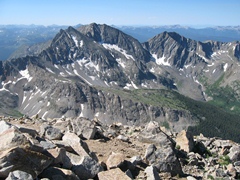 |
|||
| Trail Location: | Clear Creek / South Winfield Trailhead | ||||
| Roundtrip Length: | 11.0 Miles | ||||
| Trailhead Elevation: | 10,560 Feet | ||||
| Total Elevation Gain: | 3800 Feet | ||||
| Avg. Elev Gain / Mile: | 691 Feet | ||||
| Highest Elevation: | 14,003 Feet | ||||
| Trail Difficulty Rating: | 18.60 (strenuous) | ||||
| Parking Lot Latitude | 38.983097 | ||||
| Parking Lot Longitude | -106.441124 | ||||
Trail Description:
The standard route to the summit of Huron Peak begins from the Clear Creek / South Winfield Trailhead. To reach the trailhead drive westbound on Chaffee County 390 off U.S. Highway 24. This junction is roughly 20 miles south of Leadville, and 14.5 miles north of Buena Vista. Once on Chaffee County 390 drive 11.8 miles along the 2WD dirt road to the Winfield Ghost Town. After turning left, just past the old mining town, the parking area for 2WD vehicles is roughly 0.1 miles away. From here the road gets progressively worse, and will require a 4WD vehicle to proceed further. The trailhead is located just past the main parking area, roughly 2.1 miles from Winfield.
 The mileage listed above assumes you'll be parking in the 2WD lot. If you have a vehicle that can make it all the way to the trailhead the roundtrip hike is only 6.75 miles, with a total elevation gain of roughly 3500 feet.
Located in the Collegiate Peaks Wilderness Area of the San Isabel National Forest, Huron Peak lies along the western edge of the Sawatch Range. Topping out at an elevation of "only" 14,003 feet, Huron Peak is ranked 52nd in height among all 53 fourteeners in Colorado. The only other fourteener with a lower elevation is Sunshine Peak in the San Juan Mountains.
From the 2WD parking area hikers will walk along the dirt jeep road for roughly 2.1 miles to reach the official trailhead. From here the trek to the summit is pretty much a steady climb all the way to the top. The only respite from the climbing comes near the half-way point, along the basin just below the summit.
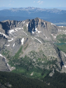
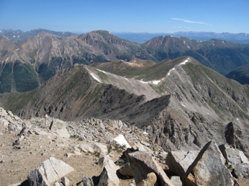
At roughly 3.8 miles (~11,900 feet) from the lower parking area, after ascending several switchbacks, hikers will emerge above the treeline. Shortly thereafter you’ll enjoy your first up-close views of Huron Peak. As you continue along this stretch the climbing moderates quite a bit as you approach the large basin below the northwestern slopes of the mountain. Over the course of the next half-mile the trail continues by cutting across to the eastern side of the basin. During this stretch you'll enjoy commanding views of 13,523-foot Browns Peak off to your left, while Huron Peak stands towards the right. Your route to the summit will follow the ridgeline on the left side of the mountain from this vantage point.
After cutting across to the far end of the basin the trail begins to ascend the steep north slopes of Huron Peak. From here it will gain roughly 1600 feet over the course of the next 1.2 miles to reach the top. This final segment is a little rugged in places, but nothing too daunting. There is some mild exposure to steep drop-offs along a few sections, but nothing that would be considered exceedingly dangerous. As with any steep hiking in the Rocky Mountains, I would highly recommend bringing trekking poles to help with balance while crossing rugged terrain, especially during windy conditions.
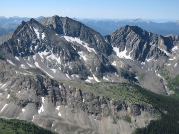
At roughly 5.5 miles from the 2WD parking area hikers will finally reach the summit. The views from the top are quite stunning, to say the least. Towards the east and southeast you can see several fourteeners in the Collegiate Range. Most prominently are the commanding views of the Three Apostles towards the south. Looking from left to right, the three thirteen-thousand foot peaks are; North Apostle, Ice Mountain and West Apostle:
Huron Peak didn't receive its official name from the U.S. Geological Survey until 1956. There's some dispute, however, about the origins of the name. It was either named for a mine that may have been in the area at one point, or possibly for the Huron Indian Tribe.
Hikers should always be aware of lightning risk while hiking in the Rocky Mountains, especially at higher elevations. As a general rule of thumb you should plan to be off the summit before noon in order to avoid the notorious afternoon thunderstorms that frequent the mountains during the summer months. Hikers should also be prepared for a variety of weather conditions while on the trail. Make sure you have the proper gear with you, and know what safety precautions you should consider beforehand.
Additional Resources:
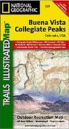
* Trails Illustrated Map for Gunnison & San Isabel Nat'l Forests, Collegiate Peaks - includes Huron Peak
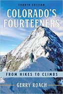
* Colorado's Fourteeners - Gerry Roach's authoritative guide to all the fourteeners in Colorado