Lake Helene
| Trail Features: | Alpine Lake, Outstanding Views | 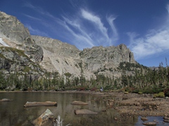 |
|||
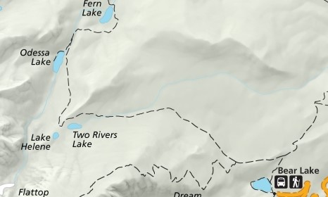
| Trail Location: | Bear Lake | ||||
| Roundtrip Length: | 6.5 Miles | ||||
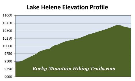
| Trailhead Elevation: | 9475 Feet | ||||
| Total Elevation Gain: | 1340 Feet | ||||
| Avg. Elev Gain / Mile: | 412 Feet | ||||
| Highest Elevation: | 10,697 Feet | ||||
| Trail Difficulty Rating: | 9.18 (moderate) | ||||
| Parking Lot Latitude | 40.31196 | ||||
| Parking Lot Longitude | -105.64581 | ||||
Trail Description:
The hike to Lake Helene in Rocky Mountain National Park begins from the Bear Lake Trailhead, located at the end of Bear Lake Road, 9 miles from the turn-off at Highway 36. Due to the extreme popularity of the area you may want to consider using the free park shuttle to reach the trailhead during peak tourist season.
 From the trailhead hikers will immediately turn right onto the Bear Lake Loop Trail. After a short walk along the shore of Bear Lake you'll make another right turn onto the trail that leads towards Odessa Lake and Flattop Mountain. From here the trail passes through a pleasant aspen grove as it ascends the slopes of the Bierstadt Moraine.
Roughly one-half mile from the trailhead you'll reach the trail that leads to Bierstadt Lake and the Mill Creek Basin. Hikers should turn left at this junction to continue towards Lake Helene.
From the junction the route begins heading due west. As it climbs higher you'll enjoy spectacular views of Longs Peak, the Keyboard of the Winds, Pagoda Peak and Chiefs Head Peak, looking towards the south.
At just over a mile from the trailhead hikers will reach the Flattop Mountain Trail, which forks off to the left. To continue on towards Lake Helene hikers should proceed straight ahead at this junction.
The first mile above the Flattop Mountain Trail junction is a steady climb through a dense pine forest. The terrain begins to ease a little during the second mile as you ascend the Mill Creek Drainage, the valley between Flattop Mountain and Joe Mills Mountain. Here the trail alternates between forest and open areas that provide excellent views of the surrounding mountains.
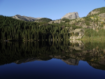
At 2.75 miles hikers will pass the side trail that leads to the Sourdough Backcountry Campsite (one campsite). A short distance beyond this junction the trail reaches its highest point. Here you'll likely notice an unmarked social trail branching off towards the left. A short walk of roughly 100 yards along this path leads to the north shore of Two Rivers Lake.
At roughly 3.2 miles from the trailhead hikers will arrive at another unmarked side path on the left side of the main trail. This route leads to Lake Helene. Immediately past this junction the main trail makes a sharp turn to the right, and begins descending rapidly towards Odessa Lake. If you've reached this point you've obviously gone too far. It's unclear why the park doesn't have a trail marker here.

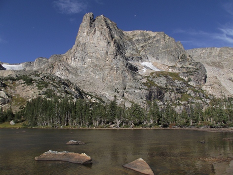
From the unmarked junction hikers will reach Lake Helene by walking a short distance on a narrow and somewhat faint path. From the shore of this beautiful subalpine lake the views are absolutely fantastic. The sentinel dominating the scene from the north shore is 12,129-foot Notchtop Mountain. To the right, looking west-northwest, is 12,331-foot Knobtop Mountain. To the south is 12,324-foot Flattop Mountain, and in between, sitting behind Flattop and Notchtop, is 12,363-foot Ptarmigan Point.