Lily Ridge Loop
| Trail Features: | Scenic Lake Views, Wildflowers | 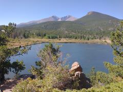 |
|||
| Trail Location: | Lily Lake Trailhead | ||||
| Roundtrip Length: | 1.2 Miles | ||||
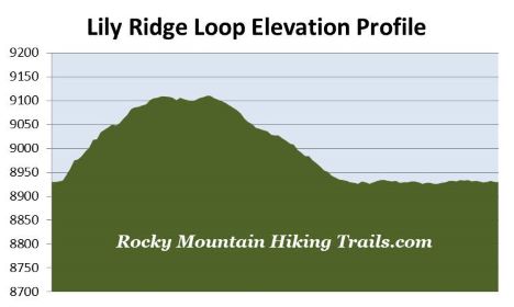
| Trailhead Elevation: | 8930 Feet | ||||
| Total Elevation Gain: | 200 Feet | ||||
| Avg. Elev Gain / Mile: | 333 Feet | ||||
| Highest Elevation: | 9110 Feet | ||||
| Trail Difficulty Rating: | 1.60 (easy) | ||||
| Parking Lot Latitude | 40.30675 | ||||
| Parking Lot Longitude | -105.53815 | ||||
Trail Description:
The Lily Ridge Loop in Rocky Mountain National Park begins from the Lily Lake Trailhead, located on Colorado Highway 7. To reach the trailhead from Estes Park, drive 6.3 miles south along Colorado Highway 7 to the Lily Lake parking area. You can park at the lake, or across the highway at the old Lily Lake Visitor Center (now closed).
The Lily Ridge Trail is a semi-loop option that provides hikers with the opportunity to view Lily Lake and the surrounding mountains from a higher vantage point. Although you can start in either direction, this description follows the loop in a counter-clockwise direction.
After walking less than a hundred yards the Lily Ridge Trail branches off to the right, just before reaching a footbridge. Almost immediately after turning onto the trail you’ll likely notice a social trail branching off to the left and heading straight up the hill. To avoid erosion and more scars on the land, the park prefers that you stay on the main trail.
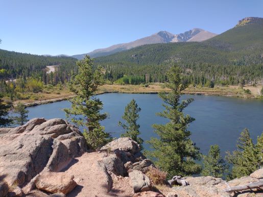
As with the loop around the shore of the lake, the Lily Ridge Trail provides outstanding views of Longs Peak, Mt. Meeker and Estes Cone towards the southwest. For photographers, I would say the views of these mountains are much better a little lower on the ridge than at the top.
After climbing, somewhat steeply in some places, hikers will reach the top of the climb at roughly one-third of a mile from the trailhead. At the top you may notice a short vertical rock slab, or nook, on the left side of the trail. Walk over to this spot and you’ll find a park bench inside. From this perch you’ll be standing almost 200 feet above the lake.
The Lily Lake area was purchased by Rocky Mountain National Park in 1992. Five years later, with funding from the Rocky Mountain Conservancy, the Lily Ridge Trail, as well as the popular handicapped accessible trail circling the lake were constructed.
 From the top of the climb the trail meanders back down to the lake. Though the backside descends along a much easier grade, there are a couple of sections where the path disappears into the landscape. You may have to use a little bit of intuition and route finding to stay on course.
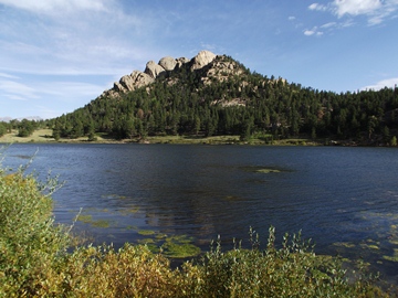
At roughly eight-tenths of a mile hikers will reach the end of the semi-loop trail. To continue on this loop hike you should turn right and proceed along the southern portion of the Lily Lake Loop Trail. The south side of Lily Lake provides great views of Lily Ridge and Lily Mountain rising above the opposite shore. At 1.2 miles hikers will return to the trailhead.
Lily Lake is situated at the headwaters of Fish Creek, which flows for roughly five miles into Lake Estes. Although the lake is natural, a dam was constructed in 1915 in order to increase its size. Prior to the dam the lake covered 14 acres of surface area, and contained roughly 39 acre feet of water. After 1915, the dam increased the surface area to 17 acres, and nearly doubled the amount of water to roughly 75 acre feet of water. In 2010 the U.S. Bureau of Reclamation rated the Lily Lake Dam as a high potential hazard. Although the park considered removing it, the decision was made to repair the dam in 2012.