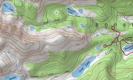
Long Lake Loop (Jean Lunning Loop)
| Trail Features: | Scenic Lake Views | 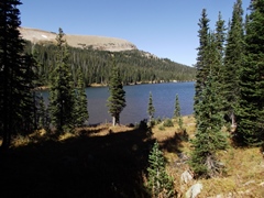 |
|||
| Trail Location: | Long Lake Trailhead (Brainard Lake Area) | ||||
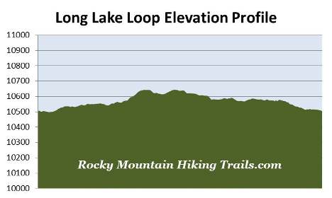
| Roundtrip Length: | 2.8 Miles | ||||
| Trailhead Elevation: | 10,505 Feet | ||||
| Total Elevation Gain: | 180 Feet | ||||
| Avg. Elev Gain / Mile: | 129 Feet | ||||
| Highest Elevation: | 10,644 Feet | ||||
| Trail Difficulty Rating: | 3.16 (easy) | ||||
| Parking Lot Latitude | 40.07781 | ||||
| Parking Lot Longitude | -105.58456 | ||||
Trail Description:
The Long Lake Loop, also known as the Jean Lunning Loop, begins from the Long Lake Trailhead in the Brainard Lake Recreation Area. To reach the trailhead from Colorado Highway 7, drive 10 miles south along Highway 72 towards the small town of Ward. Just before reaching Ward, turn right onto Brainard Lake Road (County Road 102) and drive 2.7 miles to the recreation area fee station (Brainard Lake Road is roughly 13 miles north of Nederland). After paying the service fee, drive another 2.8 miles to a split in the road where you'll turn left to reach the Long Lake Trailhead. Hikers should note that Brainard Lake Road is usually open from mid-June through mid-October, depending on weather.
After departing from the trailhead and walking roughly 0.15 miles, hikers will reach the Indian Peaks Wilderness boundary. Designated in 1972, the Indian Peaks Wilderness encompasses more than 76,000 acres of pristine mountain wilderness immediately south of Rocky Mountain National Park. The wilderness received its name as a result of several peaks within its borders being named for Native American tribes.
Just beyond the wilderness boundary hikers will arrive at the east Jean Lunning Trail junction, which marks the beginning of the loop portion of this hike. The Jean Lunning Trail circles around the south side of Long Lake, and reunites with the Pawnee Pass Trail about a mile further up the trail. Although you can proceed in either direction, this description follows the loop in a counter-clockwise direction. We therefore veered towards the right to remain on the Pawnee Pass Trail.
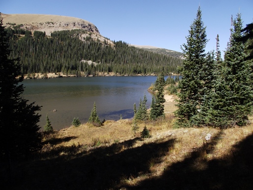
From the junction the Pawnee Pass Trail travels around the north and northwest sides of Long Lake. Although there's no access to the lake from the trail, there are a couple of short side paths that lead to the shore roughly seven-tenths of a mile from the trailhead.
This segment of the route travels through a pristine pine forest along a wide and well-used path. Sightings of moose are fairly common along this stretch, as the entire South St. Vrain Creek valley area, between Long Lake and Lake Isabelle, is prime moose habitat.
At roughly nine-tenths of a mile the trail shifts away from the lake, and gradually begins to gain elevation. At just under 1.2 miles hikers will arrive at the west Jean Lunning Trail junction. From here the Pawnee Pass Trail continues for another mile to reach Lake Isabelle. To continue on the loop, hikers should turn left onto the Jean Lunning Trail.
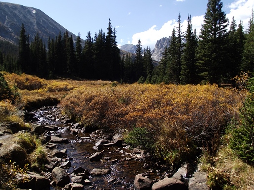
After walking a very short distance from the junction, the trail crosses over the South St. Vrain Creek. Looking upstream from the footbridge you'll have a nice view of 13,441-foot Apache Peak and 12,967-foot Shoshoni Peak.
Although you'll walk past a couple of small meadows along the way, the Jean Lunning Trail mostly travels through a pristine conifer forest. While the trail never gets close to the lake, there are several vantage points that offer good views along the route (see first photo above). The trail also passes over several sections of boardwalk, which helps to keep hikers above a few boggy areas.
At roughly 2.5 miles hikers will reach the Niwot Cut-Off Trail junction, which is currently unmarked. To continue back towards the trailhead you should turn left here.
At 2.6 miles, just below the foot of Long Lake, the trail crosses over the South St. Vrain Creek once again. From the footbridge you'll have a nice view of the lake, as well as Niwot Ridge and the mountains near Pawnee Pass.
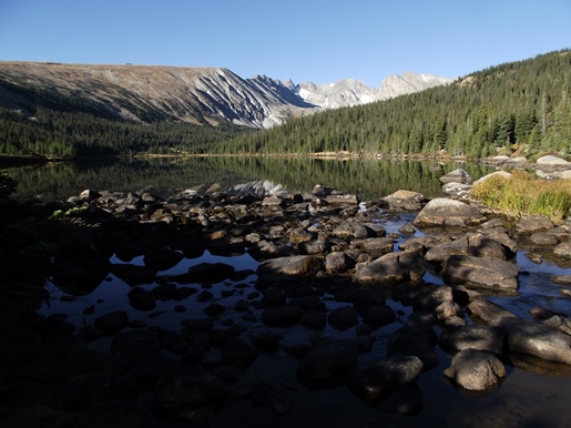
Although not considered to be the most picturesque mountain scenery in the Indian Peaks, Niwot Ridge has the distinction of being designated by the United Nations as an International Biosphere Reserve for arctic and alpine research. A program launched by the National Science Foundation in 1980, known as the Niwot Ridge Long Term Ecological Research, is trying to better understand ecological processes in high-elevation mountain ecosystems.
Just beyond the footbridge you'll reach the Pawnee Pass trail once again. Hikers should turn right at this junction to return back to the trailhead.