
Lulu City
| Trail Features: | Historic, Scenic Views, Fall Aspens |  |
|||
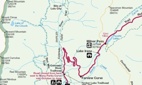
| Trail Location: | Colorado River Trailhead | ||||
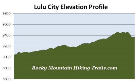
| Roundtrip Length: | 7.4 Miles | ||||
| Trailhead Elevation: | 9040 Feet | ||||
| Total Elevation Gain: | 660 Feet | ||||
| Avg. Elev Gain / Mile: | 178 Feet | ||||
| Highest Elevation: | 9465 Feet | ||||
| Trail Difficulty Rating: | 8.72 (moderate) | ||||
| Parking Lot Latitude | 40.40172 | ||||
| Parking Lot Longitude | -105.84866 | ||||
Trail Description:
The hike to the historic Lulu City site in Rocky Mountain National Park begins from the Colorado River Trailhead, located roughly 9.3 miles north of the Grand Lake Entrance, and 10.6 miles south of the Alpine Visitor Center.
Although nearly every hike on this website visits a specific destination, you could argue that this hike is more about the journey. On this route hikers will enjoy beautiful meadows and mountain scenery as they proceed along the upper portions of the Colorado River. While there’s quite a bit of history along the way, the physical remnants are rapidly decaying.
Originally constructed in 1880, hikers will travel along an old miner’s route formerly known as the Grand Lake - Lulu City Wagon Road to reach the historic site. After walking about a tenth of a mile along this former road you’ll be greeted with a fairly stiff climb. Fortunately the ascent is very brief, and the terrain levels out shortly thereafter.
There seems to be some uncertainty as to what the proper name is for this trail. On the official Rocky Mountain National Park map it’s clearly labeled as the Colorado River Trail. However, on the Nat Geo Trails Illustrated Map, and on USGS maps, it’s referred to as the La Poudre Pass Trail. Regardless of its official name, the route is straight forward and easy to follow all the way to your final destination.
At one-half mile from the trailhead hikers will arrive at the Red Mountain Trail junction. You should proceed straight ahead to continue towards Lulu City.
Over the course of the first mile the trail travels along a wide path while passing through a very pleasant mixed evergreen forest of spruce and lodgepole pine. At roughly one mile you’ll make contact with the Colorado River for the first time. As we approached the river a kingfisher greeted us with its distinctive cackle. From this point you'll be standing only 5 or 6 miles from its headwaters near La Poudre Pass in the Never Summer Mountains. Though only a modest stream here, this mighty river will travel another 1400 miles to reach the Gulf of California from this spot.
Beyond this point the trail becomes a little bit more rugged as it proceeds up the valley. However, the scenery also becomes progressively better. You’ll begin passing several aspen groves along this stretch, as well as several beautiful meadows that offer great views of the Never Summer Mountains towards the west. The meadows along the river also offer prime habitat for elk and moose.
At roughly 1.8 miles you’ll pass a rusting mining car lying downhill from the trail on the left. A short distance later you’ll pass tailings spilling down from a mine shaft on the right. This mine was operated by Joe Shipler. Hikers will pass the remnants of his cabin a little further up the trail.
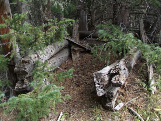
At 2.2 miles hikers will cross over Crater Creek, which is marked by a park sign. Roughly 100 yards or so past the footbridge are the remains of the Shipler Cabin. The cabin sits roughly 20 yards off to the right side of the trail. You should be on the lookout for it as you pass through this area, as it can be very easy to miss.
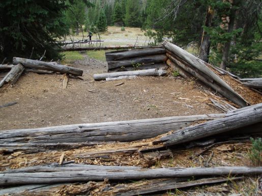
Originally there were two cabins on this site. It’s believed that Marcus Coon built one, or possibly both cabins between 1879 and 1881, and then sold them to his mining partner, Joseph Shipler. After locating several silver lodes in the Lead Mountain Mining District (northern part of the Kawuneeche Valley), Shipler moved to this site from Fort Collins. He resided here until at least 1914. A park photo shows that both cabins were still largely intact in 1938.
At 3.5 miles hikers will arrive at the spur trail for Lulu City. You should veer left at this junction and proceed downhill to reach the site. After making a fairly steep descent, the trail quickly reaches the former site of Lulu City, which is also marked by a park sign. At first glance there’s nothing that would indicate that a town ever existed here. Supposedly, however, there are still a few foundations that can be found in the vicinity if you do a little exploring. We did find the remnants of one small building, but nothing else. If you head west and southwest from the park sign you’ll find a myriad of social trails crisscrossing the area. Be careful not to get lost should you decide to explore. Have a GPS, or have someone stay behind to act as a beacon should you lose your way.
Lulu City was established in 1879 after Joe Shipler discovered silver in the vicinity. Two entrepreneurs from Fort Collins, Benjamin F. Burnett and William Baker, established the town after organizing the Middle Park and Grand River Mining and Land Development Company. The town was named after Burnett’s eight-year-old daughter, Lulu.
In the beginning prospects for Lulu City were rather grand, and the town grew rapidly. By 1880 the land company had surveyed a town site that would encompass 160 acres. The budding town was divided into 100 blocks, with 19 east-west streets, and 4 north-south avenues. The old wagon road, now the present-day trail, traveled along what was then the main street. According to a reporter at the time, lots were being sold for $20 to $50 that year.
Though the park sign at the site indicates that the population was 200, historians have noted that as many as 500 people once lived here. At its peak, in 1881, there were forty cabins, two sawmills, a hotel, general store, clothing store, grocery store, dairy store, butcher shop, post office, barber shop, blacksmith shop, assay office, real estate agency, liquor store, multiple saloons, and “a two-cabin red light district just north of the town to service the region’s miners”.
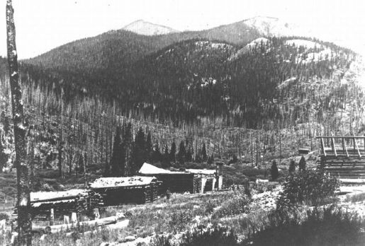
Unfortunately for both the land prospectors and the miners, the town began to decline during the following year. Most miners left during the winter of 1882/83, and the last activity was recorded in 1884. The small amounts of ore mined out of the mountains proved to be too low grade, and the cost of shipping it to have it smelted was far too high. By the following decade Lulu City had become a ghost town. The following photograph provides a glimpse of what the abandoned town looked like in 1889:
The Lulu City site became part of Rocky Mountain National Park in 1949, and was placed on the National Register of Historic Places in 1977. The documentation for that application states that “Physical ruins at Lulu City consist of three recognizable cabin ruins with lesser remains of six other buildings identifiable as well.” A 2006 report published by Park Archeologist, William B. Butler, stated that “The only visible structural remains of the former town are remnants of a log cabin, several ephemeral building platform outlines, a bear trap, and several light scatters of artifacts on the surface”.
If you wish to learn more, C. W. Buchholtz provides a much broader history of Lulu City and the mining activities in the region before the establishment of the park in his book, Rocky Mountain National Park: A History.
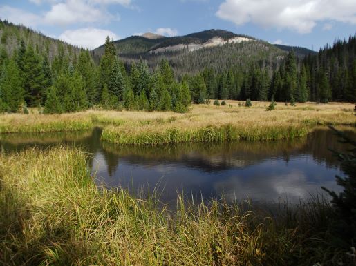
After checking out the historic site hikers will have a few options. You can venture down the old wagon trail for a short distance to visit the Colorado River. You can also walk a short distance northbound along the main trail to where a small creek empties into the Colorado River. Just beyond that point is a broad grassy meadow with a couple of easily accessible ponds. The scenery here is outstanding. Look closely towards the towering mountains and you’ll be able to see the Grand Ditch cutting a scar along the mountains. By checking a detailed trail map you might notice that you’ll have an opportunity to continue along the main trail to form a lollipop loop, or continue to the Little Yellowstone Trail, located roughly a mile away.