
Lumpy Ridge Loop
| Trail Features: | Scenic Views, Wildflowers, Fall Aspens | 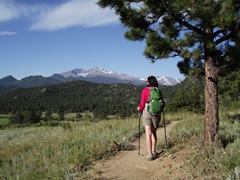 |
|||
| Trail Location: | Lumpy Ridge Trailhead | ||||
| Roundtrip Length: | 11.0 Miles | ||||
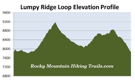
| Trailhead Elevation: | 7870 Feet | ||||
| Total Elevation Gain: | 2475 Feet | ||||
| Avg. Elev Gain / Mile: | 450 Feet | ||||
| Highest Elevation: | 9172 Feet | ||||
| Trail Difficulty Rating: | 15.95 (strenuous) | ||||
| Parking Lot Latitude | 40.39655 | ||||
| Parking Lot Longitude | -105.51319 | ||||
Trail Description:
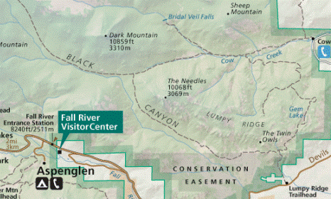
The Lumpy Ridge Loop in Rocky Mountain National Park begins from the Lumpy Ridge Trailhead, located just north of Estes Park. To reach the trailhead from the intersection of Wonderview Avenue (34 Bypass Road) and MacGregor Avenue in Estes Park, turn to travel northbound on MacGregor Avenue. The Lumpy Ridge Trailhead will be on your left after driving 1.2 miles. You may want to note that MacGregor Avenue makes a sharp right turn, at which point it turns into Devils Gulch Road, just before reaching the trailhead access road.
 The Lumpy Ridge Loop (also known as the Twin Owls Loop) circles around Lumpy Ridge, a massive granite rock outcropping that’s been sculpted by wind and erosion over the last 1.8 billion years. Although you can hike the loop in either direction, we chose to hike in a clockwise direction so that the views of Longs Peak and the mountains along the Continental Divide would be at their best during the early morning light. If you wish to avoid the afternoon crowds at Gem Lake, however, you may want to travel in a counter-clockwise direction. With that said, we started our hike up the Lumpy Ridge Trail and headed towards Twin Owls and the Black Canyon Trail.
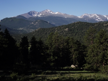
From the trailhead the path climbs sharply for a couple hundred yards, and then makes a rapid descent down towards the broad valley of the MacGregor Ranch. Soon the mountains along the Continental Divide, as well as Longs Peak, come into view.
At seven-tenths of a mile you'll arrive at the Black Canyon Trail junction. Hikers should turn left here to continue on the loop. Just past this junction the trail crosses over a driveway that leads to an NPS employee residence.
 Lumpy Ridge is a very popular rock climbing area. As you proceed along the Black Canyon Trail you'll notice several side trails that lead up towards the ridge. Unfortunately for climbers these areas are also home to a variety of raptors, such as goshawks, peregrine and prairie falcons, red-tailed and Cooper's hawks, as well as turkey vultures. As a result, the park closes some of these climbing areas, usually from early March through the end of July, to ensure that these birds of prey remain undisturbed during their breeding and nesting seasons.
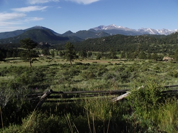
As you proceed along the Black Canyon Trail the valley below on your left is part of the historic MacGregor Ranch. The ranch, along with the nearby 10,486-foot MacGregor Mountain, are both named after Alexander and Clara MacGregor who established their 160-acre homestead in Black Canyon in 1873. Over the years the ranch grew to 1240 acres, but when one of their descendants died in 1970, park officials became concerned that the land might be sold for subdivisions or condominiums. In 1983 the park purchased a conservation easement covering 1221 acres of the ranch, which permanently maintains the undeveloped attributes of the property. While much of the ranch is located within the authorized boundary of the park, it still remains private property. Today the property is operated as a working ranch, youth education center, historic site and a public museum.
 This section of trail that passes through the MacGregor Ranch is absolutely stunning. In addition to great views of the surrounding mountains, it's also an outstanding destination during the spring and early summer for wildflowers. During the fall the trail will also offer plenty of golden-yellow aspens.
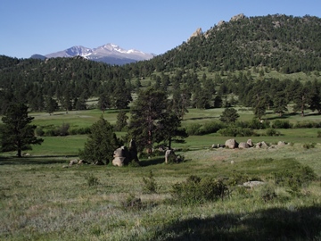
Once beyond the MacGregor Ranch the trail begins a steady climb up Black Canyon where it passes between MacGregor Mountain and The Needles. Fortunately the path travels through a pretty thick pine forest, which offers quite a bit of protection from the sun during hot summer days.
Reaching a height of 10,068 feet, The Needles are the highest point on Lumpy Ridge. The Arapahoe Indians referred to them as tha thay-ai ay tha, meaning "Little Lumps on Ridge".
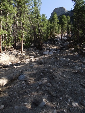 At roughly 3 miles from the trailhead you'll reach a section of trail that was washed out by the September 2013 floods. During the historic storm Estes Park received 9.4 inches of rain, while a rain gauge just south of Marys Lake reported 11.5 inches. The storm knocked out roads and bridges, stranded residents, and killed 8 people in the Front Range area. Rocky Mountain National Park also received significant damages to roads, bridges and trails, which kept most of the park closed for almost two weeks. The washout in Black Canyon created a fairly large scar on the land, but it only impacted roughly 20 yards or so of trail. The route through this section is very easy to navigate.
At roughly 3.9 miles you'll reach the Dark Mountain Trail junction. Except for a very short portion beyond the junction, this also marks the end of the first long climb of the day. At the junction the trail to the left leads towards Lawn Lake. To continue on the loop hike, hikers should turn right and begin heading towards the Cow Creek Trailhead.
Just past the junction the trail begins heading downhill, passing between Dark Mountain and The Needles along the north side of Lumpy Ridge. Soon you'll leave the overhead canopy of the pine forest and enter into open terrain with large grassy meadows.
At 5.6 miles you'll arrive at the Cow Creek Trail junction. A turn to left will lead hikers up to Bridal Veil Falls. To continue on the loop you should proceed straight ahead at this junction.
At 6.4 miles hikers will reach the Gem Lake Trail junction. Continuing straight ahead will lead to the Cow Creek Trailhead. Hikers should turn right here to begin heading towards Gem Lake and the Lumpy Ridge Trailhead.
 Just past this junction you'll reach another washout area. This one impacted a section of trail roughly 30 or 40 yards in length. Although it might look a little confusing at first, simply follow the cairns to guide you through to the other side.
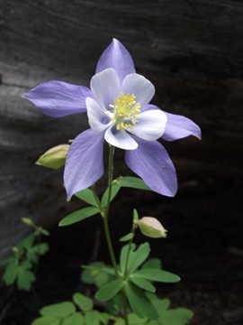
Soon after leaving the washout area the trail crosses Cow Creek and travels through a few more meadows, and then begins to make a steep ascent up to the east side of Lumpy Ridge. Throughout this section we saw a plethora of wildflowers, including several columbines.
This section of trail, all the way to Gem Lake, is a steep slog. There will be several points where you’ll think the climbing is finished, only to discover that they were only "false summits".
At just over 8 miles from the trailhead you'll reach the side trail that leads to Balanced Rock. To continue on the loop, stay towards the left to proceed along the main trail.
As the trail climbs higher you'll enjoy some pretty decent views of the Mummy Range looking towards the west.
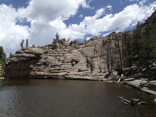
At roughly 9.25 miles hikers will reach Gem Lake, one of the more popular destinations in the park. The lake has the fairly unique distinction of having neither an inlet or outlet stream. Instead, the lake is formed by trapped snowmelt and rainwater that collects in a basin carved out of the base of the granite cliff walls that surround the lake.
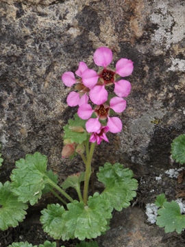
While at the lake we were very fortunate to have struck up a conversation with a photographer who pointed out that he was there to take photos of a rare wildflower known as Telesonix jamesii. This beautiful pink flower (see photo further below) grows in the crevices of the granite walls that surround Gem Lake, as well as a few other places in the Rockies. The occurrence of this rare wildflower was one of the reasons for the relocation of the original Gem Lake and Twin Owls Trailheads.
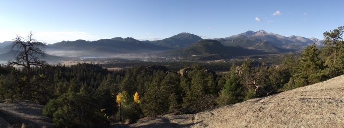
Just past Gem Lake the trail begins to descend. Near the top you'll have some absolutely spectacular views of Estes Park, Mt. Meeker, Longs Peak, as well as the mountains along the Continental Divide. This portion of the trail, all the way down to the Gem Lake Trailhead, was added to the National Register of Historic Places in 2008.
The descent from the lake is quite steep, and has quite a few rock steps built into the cliff face to help hikers descend safely. Many of the steps are one or two feet in height, which will make progress a little slow for some people. You may want to consider bringing trekking poles for this stretch of the trail.
As the trail descends you'll pass several points that offer some great views of the surrounding mountains. You'll also pass through some areas with huge boulders, as well as some very interesting rock formations.
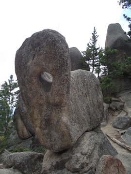
At roughly 9.6 miles you'll reach Paul Bunyan's Boot, perhaps the most interesting rock formation of them all. Just past the boot is a series of small, short switchbacks that almost gives you the impression of walking down a spiral staircase.
There are many aspens along this stretch of the trail, making this a great option for a fall hike.
At roughly 10.5 miles hikers will reach the Black Canyon Trail junction, which forks off towards the right. To continue on towards the Lumpy Ridge Trailhead you should veer left at this junction. The trailhead is only a half-mile away from this point. This last stretch of trail travels through a narrow, boulder-strewn canyon, while passing many more aspens and ponderosa pine.