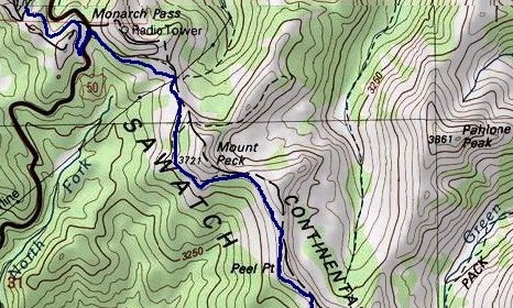
Monarch Crest Trail
| Trail Features: | Outstanding Views |  |
|||
| Trail Location: | Monarch Pass | ||||
| Roundtrip Length: | 8.8 Miles | ||||
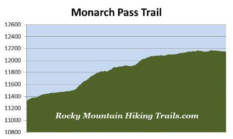
| Trailhead Elevation: | 11,312 Feet | ||||
| Total Elevation Gain: | 900 Feet | ||||
| Avg. Elev Gain / Mile: | 205 Feet | ||||
| Highest Elevation: | 12,170 Feet | ||||
| Trail Difficulty Rating: | 10.6 (strenuous) | ||||
| Parking Lot Latitude | 38.49615 | ||||
| Parking Lot Longitude | -106.3252 | ||||
Trail Description:
The hike along the Monarch Crest Trail in the San Isabel National Forest begins from Monarch Pass. The trailhead is located at the top of the pass on U.S. Route 50, roughly 21.5 miles west of Salida, and 18 miles west of Poncha Springs. The hike begins along a paved road heading up the mountain between the Monarch Pass Gift Shop and the gondola building for the Monarch Tramway. After walking a very short distance it turns into a dirt road. At roughly one-third of a mile you'll arrive at the Continental Divide Trail junction. Hikers should turn right onto this narrow footpath, which immediately begins a short descent along a steep embankment. This section of trail will provide you with some nice views towards the west.
The Monarch Crest Trail, also known as the Monarch Pass Trail, travels for a total of 11.5 miles while following the Continental Divide Trail to reach Marshall Pass. Due to the outstanding scenery, and a relatively small amount of elevation gain, this trail is considered to be one of the most popular mountain biking routes in Colorado.
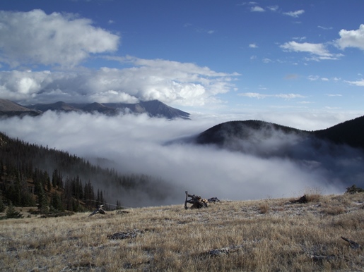
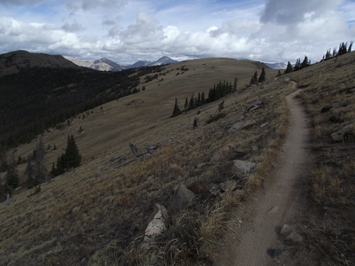
On the morning of our hike we started out with some very low hanging clouds over Salida and Poncha Springs. As we drove towards the trailhead we began to encounter fog, which thickened considerably as we progressed higher. When we got to within a quarter-mile of the pass there was less than 50 feet of visibility. At this point we had some serious doubts as to whether it would make sense for us to hike in conditions that appeared to offer little or no chances of seeing any of the surrounding scenery. Incredibly, just as we reached the summit of the pass we emerged above the fog, and had nothing but brilliant blue skies and white billowy clouds above us. As you can see from the photo below, the fog lingered below the east side of the pass for much of the day.
At just over a mile from the trailhead the path dead-ends into a dirt road as it passes below a large power line. Hikers should turn right onto this road to continue along the Continental Divide Trail. From the junction the trail begins to ascend again. Although this is technically only a moderate climb, the altitude will make it feel strenuous, especially if you're not acclimated. I would highly recommend spending at least one or two days adjusting to the altitude before attempting this hike.
At just under 1.6 miles the dirt road (presumably the North Fooses Creek Road) branches off towards the left. Hikers should stay to the right to continue along the Monarch Crest Trail. Roughly two-tenths of a mile beyond the junction the trail emerges above the treeline where you'll enjoy some absolutely fantastic views towards the west. Shortly thereafter 12,050-foot Chipeta Mountain and 13,971-foot Mt. Ouray will appear towards the southeast.
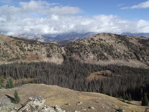
The trail continues to ascend along a series of easy to moderate grades, and eventually begins to travel above 12,000 feet where you'll enjoy outstanding panoramic views in all directions. At roughly 3.75 miles the trail begins to circle around the western slopes of 12,145-foot Peel Point. We continued to the south side of the mountain where we ended our hike along a fairly narrow ridgeline. This spot, roughly 4.4 miles from the trailhead, offers great views towards the east, including 12,667-foot Pahlone Peak and the South Fooses Creek drainage. Because the Monarch Crest Trail runs for 11.5 miles you can travel any distance you like. You could continue for another seven-tenths of a mile to reach the South Fooses Creek Trail junction. For a shorter option you could end your hike on the north side of Peel Point, at roughly 3.75 miles from the trailhead, a spot that arguably offers some of the best views along the route described here. You'll also have the opportunity to climb Peel Point. While approaching from the north you'll notice a faint, unmarked trail leading towards the summit. Hikers should note that there may be some off-trail trekking involved with this option.
Hikers should always be aware of lightning risk while hiking in the Rocky Mountains, especially at higher elevations. As a general rule of thumb you should plan to be off exposed ridges and summits before noon in order to avoid the notorious afternoon thunderstorms that frequent the mountains during the summer months. Hikers should also be prepared for extreme sun exposure, wind, cool temperatures, and rapidly changing weather conditions while on the trail. Make sure you have the proper gear with you, and know what safety precautions you need to consider beforehand.