
Mount Ida
| Trail Features: | Outstanding Panoramic Views | 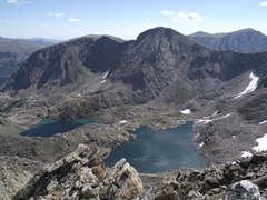 |
|||
| Trail Location: | Milner Pass | ||||
| Roundtrip Length: | 9.6 Miles | ||||
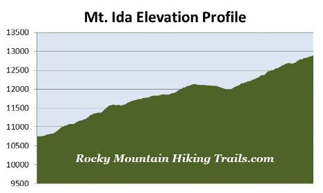
| Trailhead Elevation: | 10,759 Feet | ||||
| Total Elevation Gain: | 2465 Feet | ||||
| Avg. Elev Gain / Mile: | 514 Feet | ||||
| Highest Elevation: | 12,889 Feet | ||||
| Trail Difficulty Rating: | 14.53 (strenuous) | ||||
| Parking Lot Latitude | 40.4203 | ||||
| Parking Lot Longitude | -105.8114 | ||||
Trail Description:
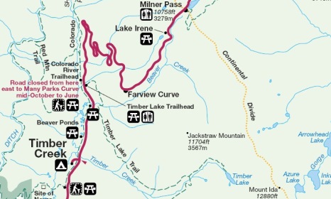
The hike to Mount Ida in Rocky Mountain National Park begins from the Poudre Lake Trailhead at Milner Pass, located 15.7 miles north of the Grand Lake Entrance, and 4.2 miles south of the Alpine Visitor Center.
On the surface this hike might appear to be relatively easy when compared to other hikes of similar mileage and elevation gain. Numbers, however, can sometimes be deceiving. Hikers will be exposed to sun, wind, and potential thunderstorms along most of this route. Moreover, the last 1.2 miles to the summit traverses over fairly rugged terrain that requires off-trail trekking, as well as some route finding. Most importantly, if near the summit and caught in an approaching storm, it will take a couple of hours to get below treeline and out of immediate danger from lightning. In all, it took us roughly 5.5 hours to complete this hike.
 Having said all that, if you start your hike early, are prepared for a variety of weather conditions, and don't mind a little off-trail travel, this hike is very rewarding. In fact, I would have to say that this is my favorite hike in Rocky Mountain National Park. The views along the Continental Divide, as well as from the summit of Mt. Ida are simply amazing.
The hike begins by circling around the southern end of Poudre Lake. Once past the lake the trail begins climbing through a lush subalpine forest. At just over six-tenths of a mile from the trailhead you'll arrive at the Mt. Ida Trail junction. The trail to the left proceeds towards Forest Canyon Pass. To continue towards Mount Ida hikers should turn right at this junction and begin heading southbound.
Once past the junction, as the trail ascends higher, hikers will be treated to sporadic views of the Never Summer Mountains towards the west.
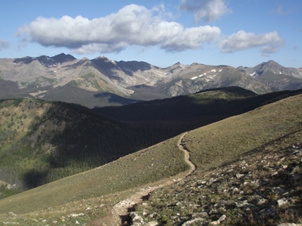
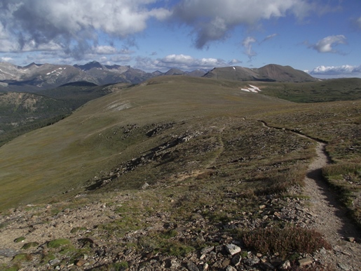
At just over 1.1 miles from the trailhead, and an elevation of roughly 11,350 feet, the trail emerges above the treeline. From this point forward the route alternates between fairly steep ascents and level terrain. As you proceed higher look for bighorn sheep and elk grazing in the open tundra. The views of the Never Summer Mountains along this stretch are also quite spectacular.
At just over 2.8 miles you'll arrive at a fork in the trail, marked by a fairly large cairn. This junction sits near the top of an unnamed mountain, simply known as Peak 12,150 on trail maps. From this lofty perch you'll be able to see Specimen Mountain towards the north, as well as Shadow Mountain Lake towards the southwest. To continue towards Mt. Ida hikers should take the right fork. From this junction the trail continues with a fairly long descent towards the saddle between Peak 12,150 and Mt. Ida.
At 3.5 miles hikers will arrive at the base of Mt. Ida. Up to this point the trail is well defined and easy to follow. However, from this point forward the route begins traversing along a very rugged and rocky landscape to the summit. Following the trail becomes more of a challenge as well. In many places it's difficult to locate the path. However, there are several cairns to help guide the way, provided that you can spot them. Coming down the mountain on our return trip we realized we made a mistake, which took us slightly off track during our ascent. Roughly a half-mile above the lowest point on the saddle you'll reach a relatively flat section in the terrain. Somewhere in this vicinity, likely in the first band of talus we crossed, we lost the path and more or less took the most direct route towards the summit. Unfortunately this route took us through a rugged boulder field. To avoid this mistake, look for the trail as it heads towards the right of the boulder field. In the photo below you can see the route we took, which is represented by the blue line. The easier route goes towards the right of the boulder field, and continues by hooking towards the left, while staying to the right of the larger boulders. The correct route is represented by the red line in the photo below.
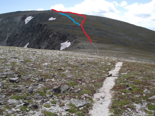
If in any doubt, simply continue upward using the path of least resistance.
As you climb higher you may see a variety of wildflowers that only survive on the tundra, such as arctic gentian or alpine sunflowers. You should also keep an eye out for marmots, picas and ptarmigans.
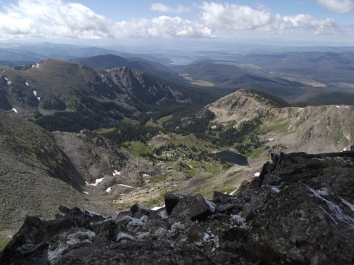
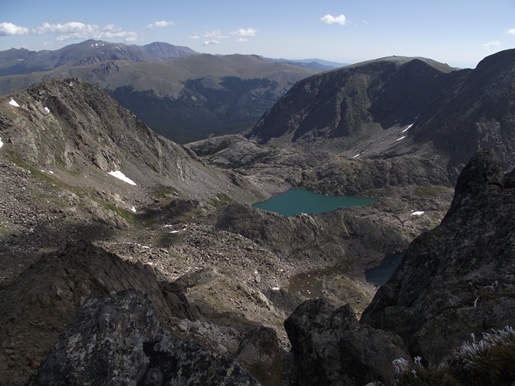
At 4.8 miles hikers will finally reach the summit of Mt. Ida. At 12,889 feet, the peak ranks as the 25th highest mountain in the park. In my opinion the mountain offers some of the best views in the park, and as such, ranks number one on our list of the best hikes in Rocky Mountain National Park. Hikers will enjoy sweeping 360-degree views, which include the Never Summer Mountains towards the west, the Mummy Range towards the northeast, Terra Tomah Mountain, Mt. Julian and Cracktop Mountain immediately to the east, Longs Peak to the southeast, and the Kawuneeche Valley, Julian Lake, Big Meadows and Shadow Mountain Lake towards the southwest. Sitting in the cirque basin more than a thousand vertical feet below is Azure Lake and Inkwell Lake.
Although there are a couple short sections of mild exposure to steep drop-offs, the trail shouldn't be considered exceedingly dangerous, at least from my perspective. The most dangerous parts of the hike are with regards to lightning exposure, or the possibility of twisting an ankle while traversing the rocky terrain near the summit. You may want to consider bringing trekking poles for this segment of the hike.
Hikers should always be aware of lightning risk while hiking in the Rocky Mountains, especially at higher elevations. As a general rule of thumb you should plan to be off the summit before noon in order to avoid the notorious afternoon thunderstorms that frequent the mountains during the summer months. Hikers should also be prepared for extreme sun exposure, wind, cool temperatures, and rapidly changing weather conditions while on the trail. Make sure you have the proper gear with you, and know what safety precautions you need to consider beforehand.