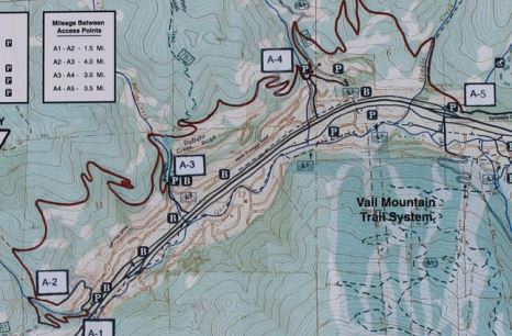
The North Trail
| Trail Features: | Scenic Views, Fall Aspens | 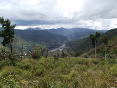 |
|||
| Trail Location: | North Trail TH #4 (Red Sandstone Road) | ||||
| Roundtrip Length: | 3.2 Miles | ||||
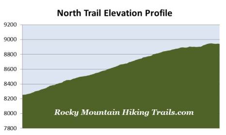
| Trailhead Elevation: | 8254 Feet | ||||
| Total Elevation Gain: | 725 Feet | ||||
| Avg. Elev Gain / Mile: | 453 Feet | ||||
| Highest Elevation: | 8950 Feet | ||||
| Trail Difficulty Rating: | 4.65 (easy) | ||||
| Parking Lot Latitude | 39.6484 | ||||
| Parking Lot Longitude | -106.39622 | ||||
Trail Description:
While driving through Colorado along I-70, have you ever wished you were instead hiking in the mountains? The North Trail in Vail offers motorists the perfect opportunity to get out and stretch their legs, all the while taking in some outstanding mountain scenery. Moreover, the trailhead is less than 5 minutes from the highway, making it a pretty convenient stop if you only have limited time.
The North Trail runs along the mountains to the north of Vail, and has several trailheads or access points. The route basically parallels I-70, across the valley from the ski area.
Our hike began from Trailhead 4, located off Red Sandstone Road. If coming from the east, take Exit 176 and travel west for roughly 1 mile on North Frontage Road (which parallels I-70 on the north side of the highway), and then turn right onto Red Sandstone Road. If approaching from the west, take Exit 173 and travel eastbound on North Frontage Road for 1.7 miles, and then turn left onto Red Sandstone Road. Once on Red Sandstone Road drive another 0.3 miles, and then turn left into the parking area at the apex of the sharp switchback in the road.
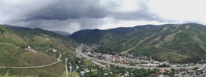
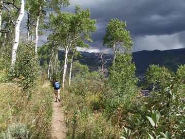
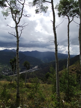
From the parking area the trail begins climbing a series of switchbacks up the mountainside. After just one-tenth of a mile you'll enter the White River National Forest. As the trail traverses up the mountain you'll have fantastic views of the town of Vail below, the Vail Ski Resort across the valley, as well as Vail Pass towards the east.
As you proceed higher the trail passes through a couple of nice aspen groves along the way. Aspens are also visible on both sides of the valley, making this a great destination for a fall hike. You should also keep an eye out for hawks riding the thermals during the summer and fall as well.
Hikers should also note that roughly 90% of this hike is exposed to the sun, and can be quite hot during the summer months.
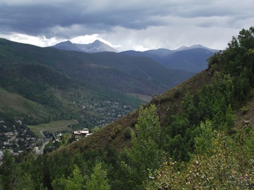
At roughly 1 mile from the trailhead you'll reach the last major switchback. Just off the side of the trail are some outstanding views towards Vail Pass and the Vail Ski Resort. Just beyond this point the trail begins to level out, and begins heading on a westerly course while passing through another aspen grove. During this section we passed some definite signs of bear activity. In the middle of the trail was some fairly fresh bear scat that included lots of fresh berries, which can be found along much of the route. It was near this same location that we noticed a really foul smell – both on the way up and back. I don't know if that was an indication that the bear was still around, but it was the only place we smelled the pungent odor.
 As we moved beyond the aspen grove we noticed that the wind
was starting to kick up, and the clouds were starting to darken quite a bit. We could also see that it was raining towards the south and east, so we decided that this was as good a place as any to end this hike. This location, roughly 1.6 miles from the trailhead, provided some nice views towards the west of the mountains in the Sawatch Range.
As we moved beyond the aspen grove we noticed that the wind
was starting to kick up, and the clouds were starting to darken quite a bit. We could also see that it was raining towards the south and east, so we decided that this was as good a place as any to end this hike. This location, roughly 1.6 miles from the trailhead, provided some nice views towards the west of the mountains in the Sawatch Range.
If you wish you can continue on for several miles beyond this point. Another mile of relatively easy walking will lead you to the Buffehr Creek Trail junction. In total, the North Trail is 11.2 miles in length, and connects with many other trails in the White River National Forest.
Hikers should note that the North Trail is closed annually between April 15th and June 15th for elk calving and migration, as well as for soil protection and erosion controls from seasonal runoff. You should also note that the trail is very popular with mountain bikers, and that dogs are allowed on the trail as well.