Pawnee Pass
| Trail Features: | Outstanding Panoramic Views | 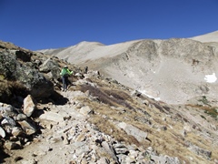 |
|||
| Trail Location: | Long Lake Trailhead (Brainard Lake Area) | ||||
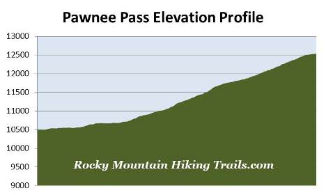
| Roundtrip Length: | 9.4 Miles | ||||
| Trailhead Elevation: | 10,505 Feet | ||||
| Total Elevation Gain: | 2050 Feet | ||||
| Avg. Elev Gain / Mile: | 436 Feet | ||||
| Highest Elevation: | 12,541 Feet | ||||
| Trail Difficulty Rating: | 13.50 (strenuous) | ||||
| Parking Lot Latitude | 40.07781 | ||||
| Parking Lot Longitude | -105.58456 | ||||
Trail Description:
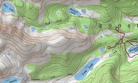
The hike to Pawnee Pass begins from the Long Lake Trailhead in the Brainard Lake Recreation Area. To reach the trailhead from Colorado Highway 7, drive 10 miles south along Highway 72 towards the small town of Ward. Just before reaching Ward, turn right onto Brainard Lake Road (County Road 102) and drive 2.7 miles to the recreation area fee station (Brainard Lake Road is roughly 13 miles north of Nederland). After paying the service fee, drive another 2.8 miles to a split in the road where you'll turn left to reach the Long Lake Trailhead. Hikers should note that Brainard Lake Road is usually open from mid-June through mid-October, depending on weather.
After departing from the trailhead and walking roughly 0.15 miles, hikers will reach the Indian Peaks Wilderness boundary. Designated in 1972, the Indian Peaks Wilderness encompasses more than 76,000 acres of pristine mountain wilderness immediately south of Rocky Mountain National Park. The wilderness received its name as a result of several peaks within its borders being named for Native American tribes.
 Just beyond the wilderness boundary hikers will arrive at the east Jean Lunning Trail junction. This footpath loops around the south side of Long Lake, and reunites with the Pawnee Pass Trail roughly one mile further up the trail. To continue directly towards Pawnee Pass hikers should veer to the right to remain on the Pawnee Pass Trail. If your intention is to only visit Pawnee Pass on this hike, you may want to consider taking a left at this junction and walking a very short distance to a footbridge at the foot of Long Lake. During the morning hours you'll enjoy a nice view of Long Lake, Niwot Ridge and the rugged mountains near Pawnee Pass.
Although not considered to be the most picturesque mountain scenery in the Indian Peaks, Niwot Ridge has the distinction of being designated by the United Nations as an International Biosphere Reserve for arctic and alpine research. A program launched by the National Science Foundation in 1980, known as the Niwot Ridge Long Term Ecological Research, is trying to better understand ecological processes in high-elevation mountain ecosystems.
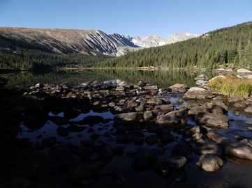
From the junction the trail travels around the north and northwest sides of Long Lake. Although there's no direct access to the lake from the Pawnee Pass Trail, there are a couple of short side trails that lead to the shore roughly seven-tenths of a mile from the trailhead.
This segment of the route travels through a pristine pine forest along a wide and well-used footpath. Sightings of moose are fairly common along this stretch, as the entire South St. Vrain Creek valley area, between Long Lake and Lake Isabelle, is prime moose habitat.
At roughly nine-tenths of a mile the trail shifts away from the lake, and gradually begins to gain elevation. At just under 1.2 miles hikers will reach the west Jean Lunning Trail junction. To continue on towards Pawnee Pass you should turn right here. As mentioned above, the Jean Lunning Trail circles around the south side of Long Lake. If you wish to explore more of the area during your hike you'll have the option of taking this trail on your way back to the trailhead. This will add roughly four-tenths of a mile to your overall mileage.
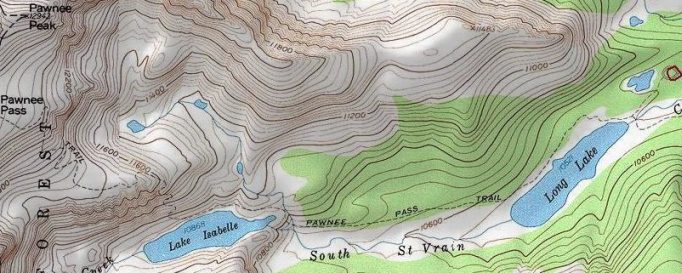
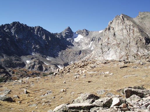
As the trail continues to push westward dramatic views of the mountains begin to emerge straight ahead. At just over 2.1 miles hikers will reach the Isabelle Glacier Trail junction. Although you should veer right to continue towards Pawnee Pass, I highly recommend walking along the Isabelle Glacier Trail for roughly one-tenth of a mile to reach an outcropping that offers an outstanding view of Lake Isabelle. This picturesque lake is framed by Niwot Ridge, 13,409-foot Navajo Peak, Navajo Glacier, 13,441-foot Apache Peak and 12,967-foot Shoshoni Peak, looking from left to right.
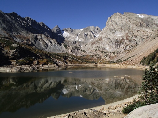
Hikers should note that Lake Isabelle is actually a reservoir, and is drained each August for agriculture purposes by a private company who owns the rights to the water. Although water levels were well below full capacity during our late-September hike, it was still an incredibly beautiful setting.
From the junction the trail climbs steeply to ascend the north ridge above Lake Isabelle. After emerging above the tree line, at roughly 2.8 miles, the footpath begins climbing a series of switchbacks. There are a couple of short sections where you'll encounter a bit of exposure to some 20 and 30-foot drop-offs, but nothing that I would consider exceedingly dangerous, and nothing really to worry about unless you have an extreme fear of heights.
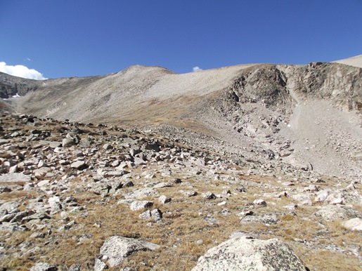
After ascending the steepest section of switchbacks the trail begins to circle around the head of the ridge. As you proceed along this stretch views of Pawnee Pass (center of photo above) and Pawnee Peak will begin to emerge towards the northwest. After circling around to the upper side of the prominence, the trail reaches the top of the climb and begins to proceed across a broad, flat alpine bench. Along this stretch you'll enjoy dramatic views of the surrounding mountains, including Niwot Ridge, Navajo Peak, Navajo Glacier, Apache Peak and Shoshoni Peak. This area, including the pass itself, is known for its abundance of wildflowers during the early summer months.
At roughly 3.7 miles hikers will reach the base of the final climb. This section of trail travels over a series of fairly steep switchbacks to reach the top of the pass. Fortunately there's no exposure to any steep drop-offs along this stretch. However, snow and ice can linger along this section until July, thus making it a technical climb before it melts out. After ascending the switchbacks you'll still have to walk another two-tenths of a mile along a fairly easy grade to reach the top of the pass.
At roughly 4.7 miles hikers will finally reach the top of Pawnee Pass, which also marks the Continental Divide. The pass lies atop a broad saddle between Pawnee Peak to the north, and Peak 12,878 to the immediate south. The Divide also marks the boundary between the Arapaho National Forest to the west, and the Roosevelt National Forest to the east. Although a large national forest sign indicates that the elevation is 12,550 feet, the elevation listed on official maps is actually 12,541 feet.
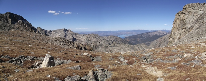
It goes without saying that the views on both sides of the pass are absolutely stunning. You should definitely consider proceeding a little further, roughly fifty yards or so, in order to enjoy the best views along the west side of the divide, which includes Lake Granby in the far-off distance.
Hikers should always be aware of lightning risk while hiking in the Rocky Mountains, especially at higher elevations. As a general rule of thumb you should plan to be off the summit before noon in order to avoid the notorious afternoon thunderstorms that frequent the mountains during the summer months. Hikers should also be prepared for extreme sun exposure, wind, cool temperatures, and rapidly changing weather conditions while on the trail. Make sure you have the proper gear with you, and know what safety precautions you need to consider beforehand.