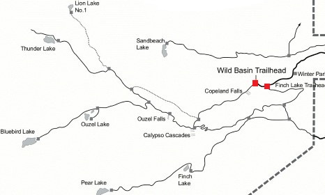
Pear Lake
| Trail Features: | Alpine Lake, Scenic Views, Fall Aspens | 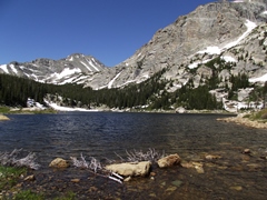 |
|||
| Trail Location: | Finch Lake Trailhead | ||||
| Roundtrip Length: | 12.8 Miles | ||||
| Trailhead Elevation: | 8470 Feet | ||||
| Total Elevation Gain: | 2575 Feet | ||||
| Avg. Elev Gain / Mile: | 402 Feet | ||||
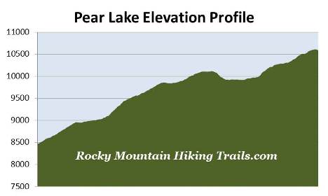
| Highest Elevation: | 10,610 Feet | ||||
| Trail Difficulty Rating: | 17.95 (strenuous) | ||||
| Parking Lot Latitude | 40.20844 | ||||
| Parking Lot Longitude | -105.5610 | ||||
Trail Description:
The hike to Pear Lake begins from the fairly remote Finch Lake Trailhead in the Wild Basin area of Rocky Mountain National Park, located near the small communities of Meeker Park and Allenspark. To reach the trailhead from Estes Park, drive 12.6 miles south on Colorado Highway 7 to the Wild Basin Road junction and turn right. After driving four-tenths of a mile make another right turn into the park. The Finch Lake Trailhead is located roughly 1.8 miles from the park turn-off on a narrow gravel road, suitable for two-wheel drive vehicles.
Almost right from the start the trail begins with a stiff climb up a ridge, gaining roughly 485 feet in just eight-tenths of a mile. Fortunately this section of the trail offers quite a few spring and early summer wildflowers along the way, including several columbines.
 Once at the top of the ridge the trail begins tracing through a very beautiful montane forest. You'll pass quite a few ponderosa pines, as well as several groves of aspens, making this a great choice for a fall hike. In fact, this entire hike passes through a very beautiful and pristine wilderness.
At roughly 1.3 miles hikers will arrive at the first trail junction of the day. The trail branching off towards the left leads to the Meadow Mountain Ranch. The trail that continues straight ahead eventually links-up with the Allenspark Trail. To continue on towards Pear Lake hikers should proceed towards the right at this junction.
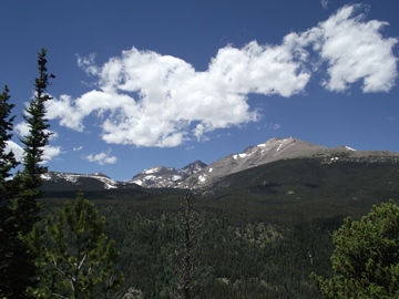
At just over 1.9 miles hikers will reach an opening in the canopy that offers an outstanding view of 13,911-foot Mount Meeker towards the northwest.
At roughly 2.3 miles you'll reach the second trail junction on this hike. The trail branching off to the left leads back to the Allenspark Trailhead. The trail veering off towards the right leads to Calypso Cascades, while the trail proceeding straight ahead continues towards Finch Lake and Pear Lake.
At roughly 2.5 miles from the trailhead you'll begin passing through a section of trail that was burned during the Ouzel Fire, which was started by a lightning strike on August 9, 1978. Because it was in a low risk zone the national park allowed the low intensity fire to smolder. However, five weeks later, on September 15th, Chinook winds exceeding 30 MPH whipped the fire out of control and threatened the small community of Allenspark. The wildfire was finally brought under control by September 30th, but wasn't fully extinguished until December 4th! In all, the Ouzel Fire burned more than one thousand acres, making it one of the largest wildfires in Rocky Mountain National Park history.
 At almost 3.9 miles you'll cross a footbridge over the stream that feeds Calypso Cascades further down the mountain. Shortly thereafter the trail begins making a sharp descent down towards Finch Lake.
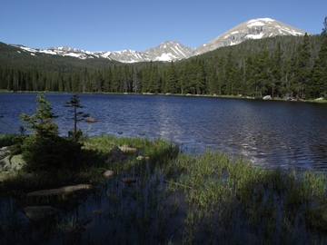
At 4.3 miles hikers will reach Finch Lake. This beautiful subalpine lake offers great views of Ogalalla Peak and Mt. Copeland off towards the west. You may want to note that the best views are from the lake's eastern shore. Simply walk about 20 or 30 yards towards your left once you arrive at the lakeshore for the most scenic views.
From the northeastern shore the main trail circles around the north side of the lake as it begins making its way towards Pear Lake. Once beyond the lake the trail crosses over Cony Creek, and then almost immediately begins a long steep climb.
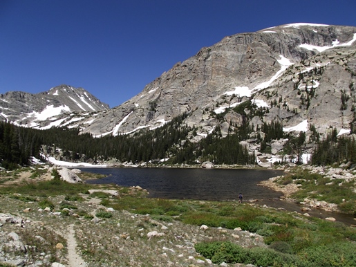
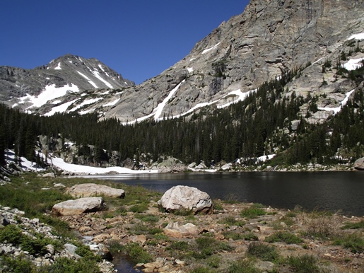
At roughly 6.1 miles hikers will cross over Pear Creek, and in just three-tenths of a mile will finally reach Pear Lake. As you might expect the views from the shore are quite awesome. Looming just above the lake is 13,176-foot Mt. Copeland, and almost directly to the west is 13,138-foot Ogalalla Peak.
Pear Lake received its name from Joe Mills, an early explorer, innkeeper, and the brother of Enos Mills, the man considered to be the "Father of Rocky Mountain National Park." He gave the lake its' name after noticing that it looked like a plump pear.
Although you can barely tell today, a dam once stood at Pear Lake. The original 26-foot-high, 140-foot-long Pear Lake Dam was constructed prior to the establishment of Rocky Mountain National Park in 1915. Made primarily of dirt and rock, the dam raised the volume of water in the natural lake, which was then used by farmers on the Great Plains. However, after the Lawn Lake Dam failure in 1982, park officials decided to remove the other three man-made dams within the park, which included Pear Lake, Sandbeach Lake and Bluebird Lake. In 1988 the park removed the structure with a bulldozer and pneumatic hammers, and then re-graded the land to its original slope. Today there's very little evidence that the dam ever existed. However, if you look closely, you may notice a "bathtub" ring on some of the boulders that surround the lake.
This hike appears to be a really good trail for spotting wildlife. We saw a couple of moose at the trailhead in the morning, as well as two of the biggest jackrabbits that I've ever seen. We also saw deer tracks over many portions of the trail, and actually had a deer circle around us as we ate lunch up at Pear Lake. Along the shore of Finch Lake we had a front row seat as a mallard came in for a landing. We even had a nesting woodpecker chirp at us fairly aggressively. With her nest being so close to the trail, she apparently didn't like us being around.