
Porphyry Basin
| Trail Features: | Outstanding Views, Lake Views, History | 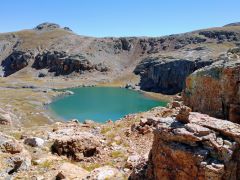 |
|||
| Trail Location: | FSR 822 at Red Mountain Pass | ||||
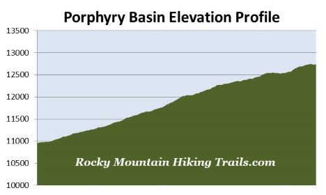
| Roundtrip Length: | 7.6 Miles | ||||
| Trailhead Elevation: | 10,958 Feet | ||||
| Total Elevation Gain: | 1820 Feet | ||||
| Avg. Elev Gain / Mile: | 479 Feet | ||||
| Highest Elevation: | 12,750 Feet | ||||
| Trail Difficulty Rating: | 11.24 (strenuous) | ||||
| Parking Lot Latitude | 37.89028 | ||||
| Parking Lot Longitude | -107.71889 | ||||
Trail Description:
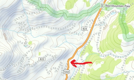
This hike to Porphyry Basin begins from the junction of Forest Service Road 822 and U.S. 550 near Red Mountain Pass. The dirt jeep road is located roughly 9 miles north of Silverton, and 13 miles south of Ouray, Colorado. More precisely, the road is located at just over six-tenths of a mile south of Red Mountain Pass, and leads west from the highway. The rugged dirt road isn’t marked with a sign, but is clearly visible as it leads up the hillside. For 2WD vehicles there’s parking for a handful of cars just off the highway. If you’re in a high-clearance 4WD vehicle you'll have the option of proceeding up the road to make this a shorter hike.
To proceed towards Porphyry Basin from U.S. 550 simply follow the dirt road up the hillside. Over the course of the first half-mile the road climbs above the highway. At just over six-tenths of a mile you’ll pass a private road branching off to the left. You should continue towards the right at this junction. At roughly 1.3 miles you’ll pass another jeep road branching off towards the right. If you’re driving a high clearance 4WD vehicle there are a couple of pull-outs just up the road from this junction where you can park. These pull-outs are located roughly 1.6 miles from the highway.
As you climb higher you’ll enjoy some absolutely spectacular views of the mountains along the U.S. 550 corridor, also known as the “Million Dollar Highway”. At roughly 2 miles, after ascending mostly steep grades up to this point, hikers will enjoy a short reprieve as the trail travels along flatter terrain for a short distance. As you proceed along this stretch you may notice a couple of waterfalls plunging down the mountains on your left.
At roughly 2.6 miles hikers will reach the end of the road. There’s a fairly large parking area here if you wish to drive all the way to this point. This area is also the site of the old Bullion King Mine, which was abandoned in the early 1900s. Other than a collapsed structure, a tailings mound and a few other remnants scattered about, there isn’t much left from that era. Located on the south side of the parking area is the trailhead for the Porphyry Basin Trail. Although there’s a discernable trail for portions of the remainder of the hike, much of this is really a “route” that requires some basic off-trail navigation skills.
From the trailhead the footpath crosses over a stream, and after a very short distance will disappear into the rock. You’ll want to stay a little towards the left to remain on the more moderate grades during this stretch, while using your intuition to follow the most likely route. After a relatively short distance you’ll pick up the trail once again. Soon afterwards the trail swings toward the right and begins heading towards the west.
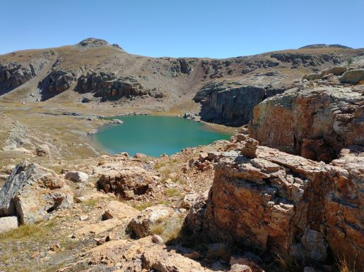
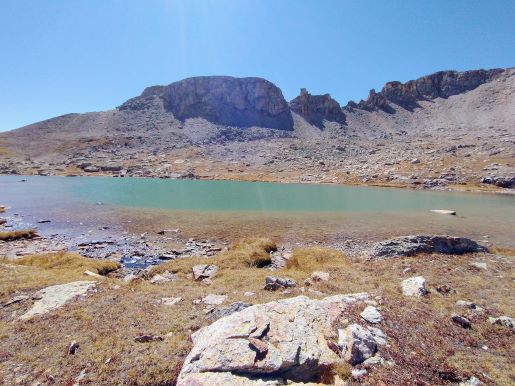
At roughly 3.1 miles hikers will reach the top of the bench, at which point you will have arrived at Porphyry Basin. Bullion King Lake comes into view at this point as well. If your goal is to explore the upper basin area you may want to resist the temptation of headng directly towards the lake from this point. Rather, you should head off-trail towards the north to cross the outlet stream and avoid the small, but impassable gorge near the lake.
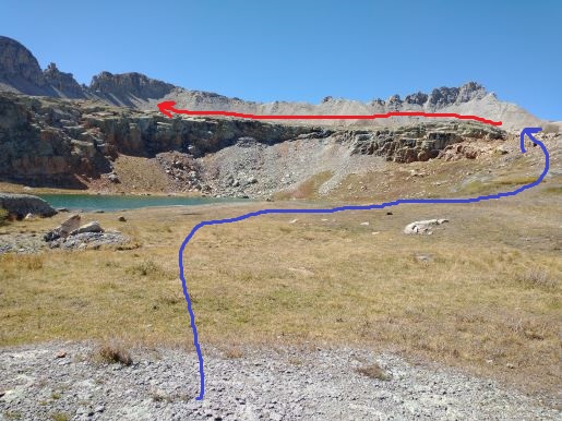
After crossing the outlet stream you may be able to pick-up a faint path as it leads towards the northeastern shore of the lake. Once at the shore the faint path continues by ascending the bench rising above the north end of the lake (see blue line in photo below). This segment of the hike provides a vantage point for the waterfall that drops through a crevice in the cliff face directly across the lake.
Once atop the bench take some time to admire the view of Bullion King Lake below. I would argue this is the best lake view in the entire basin area.
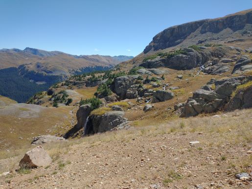
After ascending the short rock ledge to reach the upper basin area, continue following the path of least resistance by staying towards the left. Once atop the bench there are no trails to follow. If you’re uncomfortable walking off-trail, you may want to end your hike here. If you decide to proceed onward, be sure to keep an eye on your surroundings, including looking backward frequently so that you’ll be familiar with the route on your return back to the Bullion King Lake area. Because the basin is located within a box canyon, however, it would be very difficult to get completely lost.
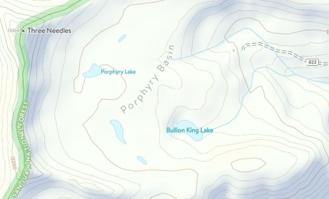
Once you’ve made it to the upper basin you’ll be able to explore the two larger lakes that rest up there. Porphyry Lake is located almost directly west, and lies in a shallow bowl below a mountain known as the Three Needles (see blue line in photo above). There’s also an unnamed lake that lies almost directly south of Porphyry Lake, and sits almost directly above Bullion King Lake (see red line in photo above). Depending on your timing, the upper basin area can be quite marshy in some places. There are numerous tarns throughout the area as well.
The upper basin was also the site of the old Porphyry Mine. During your explorations you may find a collapsed building, as well as tailing mounds from this mine.
Hikers should note that the entire hike is exposed to the elements. You should also be aware of lightning risk while hiking in the Rocky Mountains, especially at higher elevations. As a general rule of thumb you should plan to be off the summit before noon in order to avoid the notorious afternoon thunderstorms that frequent the mountains during the summer months. Hikers should also be prepared for extreme sun exposure, wind, cool temperatures, and rapidly changing weather conditions while on the trail. Make sure you have the proper gear with you, and know what safety precautions you need to consider beforehand.