Poudre River Trail
| Trail Features: | Scenic Views, River, Wildlife | 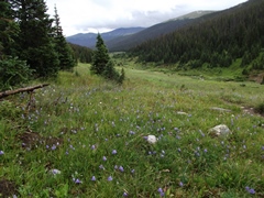 |
|||
| Trail Location: | Milner Pass (Poudre River Trailhead) | ||||
| Roundtrip Length: | 6.0 Miles | ||||
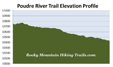
| Trailhead Elevation: | 10,755 Feet | ||||
| Total Elevation Gain: | 475 Feet | ||||
| Avg. Elev Gain / Mile: | 158 Feet | ||||
| Highest Elevation: | 10,774 Feet | ||||
| Trail Difficulty Rating: | 6.95 (moderate) | ||||
| Parking Lot Latitude | 40.42537 | ||||
| Parking Lot Longitude | -105.80543 | ||||
Trail Description:
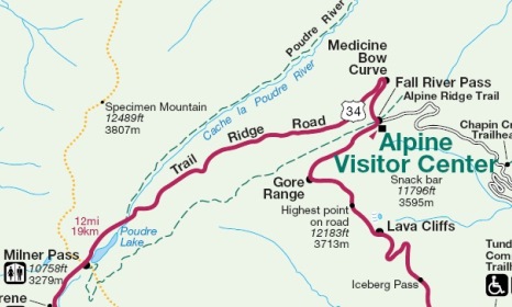
The hike along the Poudre River Trail in Rocky Mountain National Park begins from the Poudre River Trailhead at Milner Pass, located 16.2 miles north of the Grand Lake Entrance, and 3.7 miles south of the Alpine Visitor Center. The parking area for the trail has room for roughly 10 vehicles on either side of the road.
This hike might be a little bit more difficult than what you might think. Although the difference in elevation from the trailhead to the end of this hike description is only 325 feet, there are numerous ups and downs along the way, which includes crossing over several rivulets that have created some fairly steep gullies along the hillside.
 Almost immediately after starting your hike the trail crosses over the Cache La Poudre River. Fed by nearby Poudre Lake, the river is merely a trickle at this point. Over the next couple of miles the Cache La Poudre travels through the valley between Specimen Mountain and Forest Canyon Pass. After exiting Rocky Mountain National Park's northern boundary the river flows through Poudre Canyon and Fort Collins, before reaching its confluence with the South Platte River in Greely, roughly 140 miles downstream from Poudre Lake.
On this trail you'll have the option of hiking as far as you want. In total the Poudre River Trail travels roughly 10 miles to the Corral Creek Trail junction, just inside the Roosevelt National Forest boundary. We decided to end this hike at the 3-mile mark, making this a 6-mile round trip hike. There's a very large dead tree lying on the side of the trail at the 2.75-mile mark, which would probably be as good a place as any to stop, have a lunch, and take-in the scenic views of the Poudre River Valley.
 After crossing the Cache La Poudre the trail begins traveling along the west side of the river over the course of the next several miles. It never really gets close to the river itself, with the exception of a point near the 2.3-mile mark where it gets to within 30 yards or so.
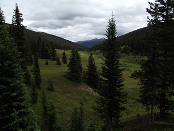
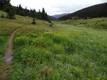
The trail meanders through open meadows and the lush evergreen forest that borders the meadows. Even during our mid-August hike we still saw quite a few wildflowers along the way. Towards the beginning of the hike there are a couple of short, steep sections that can be fairly slick when it's wet. Bringing trekking poles on this hike is probably a good idea.
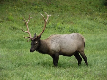
The entire length of the trail passes through prime moose, elk and deer habitat. Mornings and evenings will be the best times to spot any of these ungulates.
Depending on your timing, there are several areas that can be quite marshy. Most are very short sections, with easy ways to get around and avoid them. However, there are a couple of spots that are longer that may soak your boots. As a result, it's a very good idea to bring extra socks along to help prevent blisters in the event the ones you're wearing get soaked. Spring and early summer will be the wettest seasons, while hiking after long rainy periods will pose problems as well.
 At just over 1.5 miles from the trailhead you'll reach the first long stretch of trail that passes through swampy terrain. This section was roughly 20 yards or so in length. With a little bush whacking you should be able to find a drier route. At 2.5 miles you'll reach another stretch of swampy terrain. This section of at least 30 or more yards was the wettest part of the route during our hike. Unfortunately we were unable to find a drier course around this section.
Once beyond these two swampy areas you should take look up to your right where you'll likely notice a few vehicles traveling along the upper slopes of Trail Ridge Road.
As mentioned above, we ended this hike at roughly the 3-mile mark. Hikers will have the option of proceeding further, or ending it sooner, as there is no particular destination along this route.
Cache la Poudre is a French phrase meaning "hide the powder". Legend has it that the river received its name in 1836 when a party of fur trappers from the Hudson's Bay Company were forced to lighten their load after getting caught in a snowstorm. The trappers hid their gunpowder near the banks of the river so that it could be retrieved the following spring. However, some historians believe that the name was given as a result of a similar event in 1825, when William Ashley's expedition was caught in a snowstorm near Bellvue, Colorado.
In 1986 the U.S. Congress designated the upper portions of the Cache La Poudre River as a Wild and Scenic River.