
Rocky Mountain National Park Trail Maps
| Trails Illustrated Maps for Rocky Mountain National Park:
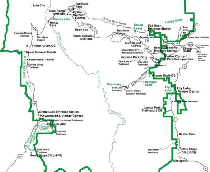
National Geographic publishes two Trails Illustrated Maps for Rocky Mountain National Park. * The original Rocky Mountain National Park Trail Map (map 200) covers the entire park. The most recent revisions to this map include easy-to-read trail mileage and markers, hiking-only and hike and horse trails are easily distinguished, Federal, State and Private lands are clearly marked, the Continental Divide Trail is highlighted, and the map is keyed to Jerome Malitz' recently updated Rocky Mountain National Park Dayhiker's Guide. The map also includes UTM grids for use with your GPS unit, and has a scale 1:50,000. * The Longs Peak Map (map 301): For much greater detail, National Geographic also publishes a sectional map that covers the Longs Peak, Bear Lake, Glacier Gorge, Moraine Park and Wild Basin area of Rocky Mountain National Park. With a scale of 1:25,000, this new sectional map provides much greater detail such as backcountry campsite locations, footbridges, fords/stream crossings, points-of-interest, shuttle stops, nature/interpretive trails, as well as water and snow hazard locations. The map also includes UTM grids for use with your GPS unit. * All Trails Illustrated Maps are waterproof and tear-resistant. All trail maps and guide books for Rocky Mountain National Park and the surrounding region, including the Indian Peaks Wilderness Area, and the Roosevelt, Arapaho and Routt National Forests, can be found here. |
 RMNP Trail Map |
|||
 Longs Peak Map |
| Day Hikes of Rocky Mountain National Park Map Guide: Unlike a map that only shows you where the trails are, or a guidebook that only provides you with an encyclopedic list of hikes, this map guide was laid out to help you quickly decide which trails to explore, using distance, slope difficulty, as well as personal recommendations from Jake Bramante, the first person to hike every mile of trail in Glacier National Park in one season.
Jake has identified 78 day hikes in Rocky Mountain National Park and has sorted them from best to least favorites. Trails are organized by distance on the guide side, and include brief descriptions for each trail. On the map side you'll find a complete list of hikes in ranking order, with indications for earlier season hiking, and hikes best suited for families. Each trail on the topographical map is color coded to indicate trail steepness. This trail guide is also waterproof and tear resistant. |
 Rocky Mountain Map Guide |
Interactive Topo Map for Rocky Mountain National Park
(zoom in to view topographical terrain data)
View Rocky Mountain National Park in a larger map