
Sandbeach Lake
| Trail Features: | Outstanding Lake Views, Fall Aspens | 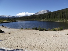 |
|||
| Trail Location: | Sandbeach Lake Trailhead | ||||
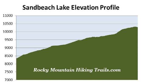
| Roundtrip Length: | 8.8 Miles | ||||
| Trailhead Elevation: | 8345 Feet | ||||
| Total Elevation Gain: | 2020 Feet | ||||
| Avg. Elev Gain / Mile: | 459 Feet | ||||
| Highest Elevation: | 10,320 Feet | ||||
| Trail Difficulty Rating: | 12.84 (strenuous) | ||||
| Parking Lot Latitude | 40.21986 | ||||
| Parking Lot Longitude | -105.53439 | ||||
Trail Description:
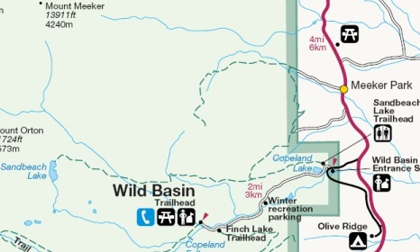
The hike to Sandbeach Lake begins from the Wild Basin area in the southeastern corner of Rocky Mountain National Park, located near the small communities of Meeker Park and Allenspark. To reach the trailhead from Estes Park, drive 12.6 miles south on Colorado Highway 7 to the Wild Basin Road junction and turn right. After driving four-tenths of a mile make another right turn into the park. The Sandbeach Lake Trailhead is located just past the entrance station on your right.
From the parking area the Sandbeach Lake Trail immediately begins to make a relatively steep climb through a ponderosa pine forest. At roughly one-third of a mile the trail crests near the top of the Copeland Moraine, which forms a long ridgeline above the north side of the North St. Vrain Creek. From here the climb moderates considerably over the course of the next mile as it travels along a contour just below the top of the ridge.
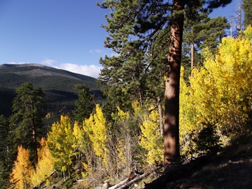 Hikers will enjoy several vantage points along this stretch that offer great views of the North St. Vrain Creek valley. Although ponderosa pine still predominates throughout this section, the trail also passes through several stands of aspens along the way. Hikers should also keep an eye for mule deer in this area. We saw several during our recent early-morning hike.
At roughly 1.3 miles the trail makes a sharp switchback away from the ridgeline, and shortly thereafter, will reach a trail that leads to the Meeker Park area. To continue towards Sandbeach Lake hikers should proceed straight ahead at this junction.
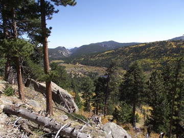
Above the junction the trail begins to follow along the lower contours of Lookout Mountain. The rugged summit of this 10,715-foot peak rises roughly three-quarters of a mile north of the trail. During this stretch the trail also passes a series of backcountry campsites, including Hole-in-the-Wall at 1.85 miles, Campers Creek at 2.05 miles, and Beaver Mill at 3.0 miles.
 At 3.25 miles hikers will pass the Hunters Creek backcountry campsite, and at just over 3.5 miles will cross over Hunters Creek.
For the most part the entire route travels over mild to moderate terrain. There are a few short sections, however, that include some relatively steep climbs.
Just before reaching the lake hikers will pass the Sandbeach Lake backcountry campground. With four campsites, this is the only backcountry campground along this route that contains multiple campsites.
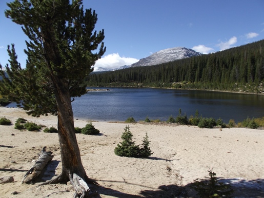
At 4.4 miles hikers will finally reach the northern shore of Sandbeach Lake. This portion of the 16.5-acre lake features a large, broad sand beach area, perfect for those looking to go home with a Rocky Mountain tan. With a maximum depth of roughly 50 feet, Sandbeach Lake is considered to be one of the deepest lakes in Rocky Mountain National Park. From its north shore 13,176-foot Mount Copeland dominates the view towards the southwest, while 12,162-foot St. Vrain Mountain can be seen looking towards the south.
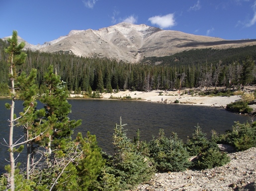
While Sandbeach Lake isn't the most popular destination in the park, its rather large size offers hikers plenty of space for relative solitude. During your visit I would highly recommend doing a little exploring to see the different perspectives of the mountains surrounding the lake. By taking the social trail leading south along the eastern shore for a short distance you'll discover an absolutely spectacular view of 13,911-foot Mt. Meeker towering above the north end of the lake. The top of Longs Peak is also visible from the southern portions of the lake. John Wesley Powell, along with several others, made the first ascent of the 14,259-foot peak in 1868. After an unsuccessful summit bid from their Grand Lake base camp, the climbing party camped near Sandbeach Lake the night before their historic first ascent. Powell, who lost an arm during the Civil War, was also the first person to float the Colorado River through the Grand Canyon.
Though you would probably never know by simply looking, a dam once stood at Sandbeach Lake. The original 26-foot-high, 90-foot-long Sandbeach Lake Dam was constructed prior to the establishment of Rocky Mountain National Park in 1915. Made primarily of dirt and rock, the dam raised the volume of water in the natural lake, which was then used by farmers on the Great Plains. However, after the Lawn Lake Dam failure in 1982, park officials decided to remove the other three man-made dams within the park, which included Sandbeach Lake, Pear Lake and Bluebird Lake. In 1988 the park removed the structure with a bulldozer and pneumatic hammers, and then re-graded the land to its original slope. Today there's very little evidence that the dam ever existed.