
Sneffels Highline
| Trail Features: | Outstanding Views, Fall Aspens, Wildflowers | 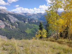 |
|||
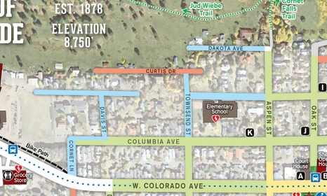
| Trail Location: | Jud Wiebe Trailhead (in Telluride) | ||||
| Roundtrip Length: | 13.9 Miles | ||||
| Trailhead Elevation: | 8905 Feet | ||||
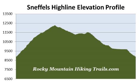
| Total Elevation Gain: | 3710 Feet | ||||
| Avg. Elev Gain / Mile: | 534 Feet | ||||
| Highest Elevation: | 12,280 Feet | ||||
| Trail Difficulty Rating: | 21.32 (strenuous) | ||||
| Parking Lot Latitude | 37.94080 | ||||
| Parking Lot Longitude | -107.81274 | ||||
Trail Description:
The Sneffels Highline loop hike begins from the Jud Wiebe Trailhead, located at the top of Aspen Street just north of downtown Telluride, Colorado. Unfortunately there isn’t any parking available at, or near the trailhead. Moreover, parking is limited to just two hours along most streets in Telluride. However, free parking is available at the Carhenge Lot located off West Pacific Avenue near the west end of town, or in the lot on the south end of Mahoney Drive, located near the west entrance to town. Both lots are located roughly a half-mile from the trailhead. You can catch a free shuttle bus called the Galloping Goose to cut-off a portion of the walk to the trailhead.
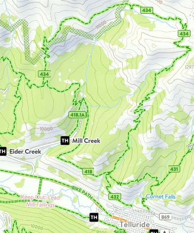 From the trailhead the Jud Wiebe Trail (#432) immediately crosses over a footbridge and begins tracking westbound. As it proceeds up the fairly steep hillside hikers will enjoy fantastic views of the Telluride Valley. At roughly eight-tenths of a mile, hikers will arrive at the Deep Creek Trail junction. You should proceed towards the left here. After following the Deep Creek Trail for about a tenth-of-a-mile, hikers will arrive at the Sneffels Highline Trail (#434) junction. You should turn right onto this trail to begin the loop portion of this hike. Hiking this loop in a counter-clockwise direction will allow you to return below tree line more easily should thunderstorms move into the area. Hikers should note that at the time of this hike, in 2022, the sign marking the Sneffels Highline Trail was down.
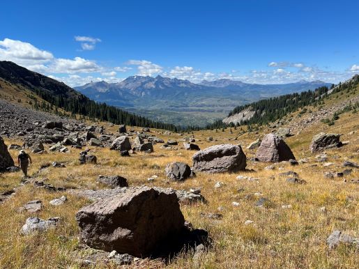
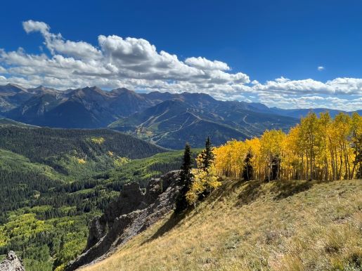
After climbing for roughly 2 miles the trail emerges above the trees for a short time. Here you’ll traverse across a grassy meadow that offers great views of Telluride Valley. If you look closely you’ll also be able to see the Lizard Head in the far off distance. As you continue higher along this strenuous stretch the trail passes in and out of forested areas where you’ll enjoy sporadic views of the surrounding mountains. Not only will you need to be in good physical shape, but you should also make sure you’re properly acclimated to higher elevations before attempting this hike.
As you proceed higher the trail ascends steeply along a couple dozen switchbacks. At roughly 3.3 miles hikers will enjoy a nice long reprieve from the relentless climbing as the trail travels through a beautiful old-growth pine forest. At roughly 4 miles you’ll reach Pack Basin where views of the surrounding terrain expand dramatically. From this point forward you’ll be fully exposed to the elements during the next 4.4 miles.
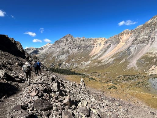
From the edge of the forest the trail proceeds northeast towards the head of the basin, which lies between the steep slopes of Greenback Mountain and Mt. Emma. After walking roughly four-tenths of a mile hikers will begin ascending a series of steep switchbacks to reach the saddle along the west ridge of 13,581-foot Mt. Emma. As you ascend these switchbacks you’ll encounter some moderate exposure to steep drop-offs. While most of the trail is in pretty good condition, there are a couple of places where you’ll definitely need to watch your footing. However, I wouldn’t consider this to be overly dangerous if you’re used to hiking in mountainous terrain.
At roughly 4.9 miles hikers will finally reach the top of the saddle. From the summit you’ll enjoy spectacular views of Pack Basin and the San Miguel Mountains towards the southwest, as well as the imposing wall that extends between Gilpin Peak and Dallas Peak towards the north. Below the wall is the Mill Creek Basin which extends into the Mount Sneffels Wilderness Area towards the west and northwest. At roughly 12,280 feet, this will be the highest point on the hike. If you’re planning to hike this loop any time before early summer, it’s best to make sure the area around the saddle is clear of snow and ice before attempting it. Hikers should also be aware of lightning risk while hiking in the Rocky Mountains, especially at higher elevations. As a general rule of thumb you should plan to be off the summit before noon in order to avoid the notorious afternoon thunderstorms that frequent the mountains during the summer months. Hikers should also be prepared for extreme sun exposure, wind, cool temperatures, and rapidly changing weather conditions while on this hike. Make sure you have the proper gear with you, and know what safety precautions you need to consider beforehand.
After soaking in the panoramic views, the trail immediately begins to descend towards Mill Creek Basin. Just below the saddle the route crosses over what appears to be a fairly recent rock slide. Over the next 30 or 40 yards hikers will encounter a little bit of moderate rock scrambling before reaching the proper trail again. Once past this section the footpath descends rapidly into the Mill Creek Basin before turning west to proceed across its length. At roughly 6.7 miles you’ll begin to hear the roar of a waterfall, located just off the side of the trail.
At roughly 8.4 miles the trail finally returns to the cover of the forest. If you’re hiking during the fall, this segment of the hike will provide some very dramatic scenery as the aspens turn brilliant hues of yellow.
Roughly 9.25 miles from the trailhead hikers will arrive at what appears to be an unmarked split in the trail. You should proceed straight ahead here to continue on the main trail.
At 9.6 miles you’ll reach the Deep Creek Trail junction. You should proceed to the left to complete the loop. From this junction the Deep Creek Trail travels through several intermittent meadows that offer more great views of the surrounding mountains.
Hikers will arrive at yet another unmarked junction at roughly 11 miles from the trailhead. You should turn left here and proceed down the hill for roughly 30 yards or so to reach the Mill Creek Road junction. You should turn left once again to continue along the Deep Creek Trail. Soon afterwards the trail crosses Mill Creek, and soon after that, begins passing what appears to be an old mining operation.
At roughly 13 miles hikers will arrive at the Sneffels Highline Trail junction, thus completing the loop portion of the hike. From here you should turn right. After walking a short distance you’ll take another right to return to the Jud Wiebe Trailhead.