Spruce Lake
| Trail Features: | Lake Views, Fall Aspens, Waterfalls |  |
|||
| Trail Location: | Fern Lake Trailhead | ||||
| Roundtrip Length: | 9.0 Miles | ||||
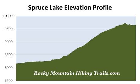
| Trailhead Elevation: | 8165 Feet | ||||
| Total Elevation Gain: | 1675 Feet | ||||
| Avg. Elev Gain / Mile: | 372 Feet | ||||
| Highest Elevation: | 9721 Feet | ||||
| Trail Difficulty Rating: | 12.35 (strenuous) | ||||
| Parking Lot Latitude | 40.35483 | ||||
| Parking Lot Longitude | -105.63109 | ||||
Trail Description:
The hike to Spruce Lake in Rocky Mountain National Park begins from the Moraine Park area. To reach the trailhead from Bear Lake Road, follow Moraine Park Road for a half-mile to an unmarked junction - just before reaching the Moraine Park Campground. Turn left at the junction and drive roughly 1.9 miles to the Fern Lake Trailhead. Along the way you'll pass the Fern Lake shuttle stop. You'll have the option of taking the free park shuttle from the Moraine Park Visitor Center, but you'll have to walk an additional eight-tenths of mile along the dirt road to reach the trailhead.
The Fern Lake Trail follows the Big Thompson River all the way to The Pool, and alternates between forest and a few open areas that provide some pretty good views of the Big Thompson Valley. Along the way you'll pass through a mixed forest of aspens, lodgepole pine, ponderosa pine, cottonwoods and willows, as well as a variety of wildflowers in the spring and summer.
This trail was mostly constructed and maintained by lodge keepers and local tourism boosters in the early 1900s. As a result of its roll in early park tourism, the Fern Lake Trail was listed on the National Register of Historic Places in 2005.
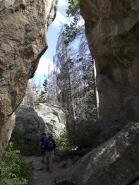 Roughly 1.2 miles from the trailhead hikers will pass through Arch Rocks, a couple of house-sized rocks that presumably landed on this spot when a large boulder fell from the cliffs above and split apart.
At 1.7 miles you'll reach the Cub Lake Trail junction. This also marks the spot where Fern Creek meets the Big Thompson River. This confluence forms the turbulent waters known as The Pool, and is a popular area for picnics and fishing.
Located near The Pool is the former site of the Forest Inn. Established in 1917, the Forest Inn featured a lodge, dining room, lounge and several cabins throughout its lifespan. The resort was sold to the National Park Service in 1952, and was razed in 1959.
Much of the area around The Pool was scorched during the Fern Lake Fire in the fall of 2012. The wildfire burned 3500 acres in the lower Forest Canyon, Cub Lake and Moraine Park areas. It's believed it was sparked by an illegal campfire on October 9th. Although it was a low intensity fire, and for the most part remained under control, it still forced the closure of almost all the trails in the Moraine Park and Bear Lake Road areas for several weeks. That all changed on November 30th when a fierce wind storm brought 70 mph gusts that pushed the fire 3 miles in only 35 minutes, and more than doubled its size as it raced across Moraine Park. At its peak more than 600 fire fighters were assigned to the blaze. The fire was all but fully extinguished when heavy snow arrived in mid-December.
Roughly two-tenths of a mile beyond The Pool is the side trail that leads to the Old Forest Inn Backcountry Campsite, which contains two individual sites. Just past the campsite the trail begins a relentless climb of almost 400 feet over the course of the next seven-tenths of a mile to reach the base of Fern Falls, a beautiful 60-foot waterfall that plunges down Fern Creek. During this stretch you'll begin passing through areas that were severly burned during the East Troublesome Fire of 2020. This historic fire scorched nearly 29,000 acres within the park boundaries, making it the largest wildfire in Rocky Mountain National Park history.
From the waterfall the trail resumes its climb, and ascends another 650 feet over the course of the next mile.
 At roughly 3.7 miles hikers will reach the Spruce Lake Trail
junction. After turning right onto this trail, the first two-tenths of a mile is a fairly steep climb. After the initial climb, however, the trail levels out for the most part.
At roughly 3.7 miles hikers will reach the Spruce Lake Trail
junction. After turning right onto this trail, the first two-tenths of a mile is a fairly steep climb. After the initial climb, however, the trail levels out for the most part.
Roughly one-tenth of a mile from the junction you'll pass the side trail that leads to the Fern Lake Individual Campground, which contains four individual sites. In 2003 two campers, in two separate tents, were bit and clawed by a black bear at this campground. In both incidents the bear attacked the campers from outside their tents while they were sleeping. Thankfully neither camper was seriously injured during this extremely rare event. The last bear attack, in or around the park, occurred in 1971 when one person was killed while camping on private property north of Grand Lake.
Although the trail is listed as unimproved on the park trailhead sign, it's fairly easy to follow for the most part. It travels through a beautiful open forest, with lots of young growth trees, mostly pine. There is one section of trail, more than a half-mile from the trailhead, and roughly one tenth-of-a-mile in length, that’s fairly rugged and takes a little more effort to stay on track. There's nothing dangerous, but you will have to pay close attention to the route while passing through this section.
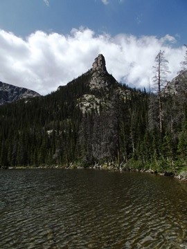
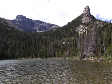
Roughly 4.5 miles from the trailhead hikers will reach Spruce Lake. Dominating the views from the lake is Gabletop Mountain on the left, and Castle Rock to the right. The lake is pleasant enough, and is a great destination if you're looking for a little solitude in this area of the park.
Near the lake is the Spruce Lake Backcountry Campsite, which contains two individual campsites.
To return back to the main trail simply retrace your steps back down the Spruce Lake Trail. Once back at the junction you might as well make the short and easy hike up to Fern Lake, since you're only a couple hundred yards away. Hikers will also have the option of reaching Spruce Lake from the Bear Lake Trailhead. This option is roughly a 12.6-mile round-trip hike.