West Creek Falls
| Trail Features: | Waterfalls, Wildflowers | 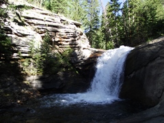 |
|||
| Trail Location: | Cow Creek Trailhead | ||||
| Roundtrip Length: | 4.4 Miles | ||||
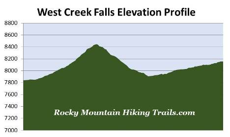
| Trailhead Elevation: | 7837 Feet | ||||
| Total Elevation Gain: | 1400 Feet | ||||
| Avg. Elev Gain / Mile: | 636 Feet | ||||
| Highest Elevation: | 8445 Feet | ||||
| Trail Difficulty Rating: | 7.2 (moderate) | ||||
| Parking Lot Latitude | 40.43129 | ||||
| Parking Lot Longitude | -105.50098 | ||||
Trail Description:
The hike to West Creek Falls begins from the Cow Creek Trailhead, located near the northeast corner of Rocky Mountain National Park. To reach the trailhead from the intersection of Wonderview Avenue (34 Bypass Road) and MacGregor Avenue in Estes Park, turn to travel northbound on MacGregor Avenue. You'll drive 3.4 miles (note that MacGregor Avenue will become Devil's Gulch Road) to McGraw Ranch Road, which will be on the left. You should also note that there isn't a sign for either the trailhead or the national park at this junction; however, there is a sign for McGraw Ranch. Although McGraw Ranch Road is a good gravel road appropriate for passenger cars, you will experience several sections of mild washboard. From the turn-off drive 2.1 miles until you see a sign that reads "no parking beyond this point". There will be a small parking area along the roadside just before reaching the sign. Simply walk the short distance down the hill and turn left at the fork in the road where you'll see a gate with signs pointing to the trailhead.
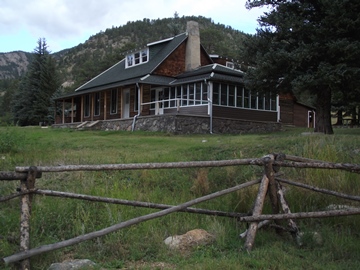 The hike begins on the grounds of the historic McGraw
Ranch. The original 160-acre ranch was established by Peter J. Pauley, Jr. in 1884. Through the years the property expanded to 1160 acres, and was eventually sold to John and Irene McGraw in 1909. The McGraw's continued ranching operations on the land for several years, but converted it to a dude ranch in 1936, and was operated as such until 1979.
The hike begins on the grounds of the historic McGraw
Ranch. The original 160-acre ranch was established by Peter J. Pauley, Jr. in 1884. Through the years the property expanded to 1160 acres, and was eventually sold to John and Irene McGraw in 1909. The McGraw's continued ranching operations on the land for several years, but converted it to a dude ranch in 1936, and was operated as such until 1979.
In 1988 the National Park Service purchased the ranch, and in 1999 began rehabilitation of the surviving buildings, many of which date back to the early 1880s and mid-1930s. This $2 million project converted the ranch into a research facility.
Immediately after passing through the research facility hikers will turn right onto the North Boundary Trail, located at just over one-tenth of a mile from the trailhead, to proceed towards West Creek Falls. The main trail continues to follow Cow Creek for another three miles to reach Bridal Veil Falls.
After turning onto the North Boundary Trail the path immediately begins to climb through a montane forest of ponderosa pine. During the late spring and early summer period hikers will enjoy a wide variety of wildflowers along this stretch. At just over three-tenths of a mile the trail leaves Rocky Mountain National Park and enters the Comanche Peak Wilderness area.
 As you climb higher you'll enjoy some nice views of Mt. Meeker and Longs Peak, though you may not notice them until your return trip. At roughly three-quarters of a mile the trail tops out along a small barren ridge, and immediately begins descending into a fairly deep canyon. At roughly 1.1 miles the trail begins to level out, and at 1.3 miles it crosses over West Creek.
From the footbridge the trail begins following West Creek, and will pass a few spots that would be great places to take an extended break along the creek. As the trail travels along the valley floor it also passes through some nice meadows that offer more spring wildflowers, including Colorado Columbine. At roughly 1.5 miles you'll reach the West Creek Falls Trail. Hikers should turn left at this junction to continue towards the falls.
At just under 1.9 miles the trail re-enters Rocky Mountain National Park. West Creek Falls is now only three-tenths of a mile up the trail. As you proceed along this last stretch the footpath becomes a little rugged where it has narrowed, or even eroded in a few places. It's best to take your time so you don't accidentally slide off the trail.
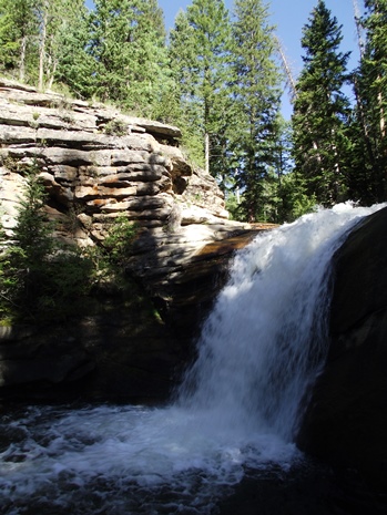
At 2.2 miles hikers will finally reach the waterfalls. West Creek Falls thunders down a narrow rocky gorge in two roughly 15-20 foot tiers. During our visit we watched an American dipper feed her hatchlings in a nest huddled within a crack along the walls of the rocky gorge. These small, slate-grey colored birds, also known as water ouzels, are known for bobbing, or "dipping" along the rocks around fast moving streams, and diving under water in search of food. Once below the surface of the water the dippers forage by either walking along the stream bottom, or by "flying" through the water, using their wings to propel themselves through the swift currents.