Mt. Chapin, Mt. Chiquita & Ypsilon Mountain
| Trail Features: | Outstanding Panoramic Views |  |
|||
| Trail Location: | Chapin Creek Trailhead | ||||
| Roundtrip Length: | 8.3 Miles | ||||
| Trailhead Elevation: | 11,040 Feet | ||||
| Total Elevation Gain: | 3100 Feet | ||||
| Avg. Elev Gain / Mile: | 749 Feet | ||||
| Highest Elevation: | 13,514 Feet | ||||
| Trail Difficulty Rating: | 14.48 (strenuous) | ||||
| Parking Lot Latitude | 40.43473 | ||||
| Parking Lot Longitude | -105.73031 | ||||
Trail Description:
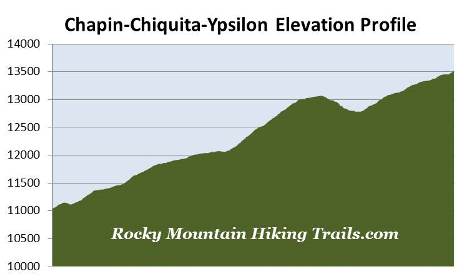
For those willing to take on the challenge, climbing the trifecta of 12,454-foot Mt. Chapin, 13,069-foot Mt. Chiquita and 13,514-foot Ypsilon Mountain is likely to be the highlight of anyone's trip to Rocky Mountain National Park. The amazing panoramic views from the three peaks along the "CCY Route" are some of the best in the park.
This hike description follows the unmaintained trail along the northwestern slopes of Mt. Chapin to the summits of both Mt. Chiquita and Ypsilon Mountain. Although we bypassed Chapin due to biting cold winds and redundancy of views, either of the three mountains would still be outstanding destinations by themselves.
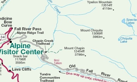
The hike begins from the Chapin Creek Trailhead, located roughly 6.7 miles from the point where Old Fall River Road becomes a one-way dirt road. Originally opened in 1920, Old Fall River Road was the first route to cross the Continental Divide in Rocky Mountain National Park. Traveling only 11 miles now, the road extends from Horseshoe Park to Fall River Pass. Although the road is suitable for two-wheel drive vehicles, you will encounter potholes and ruts. Near the trailhead there's enough room for roughly 12 to 15 vehicles in a series of pull-offs starting at the trailhead. With limited parking you'll definitely want to arrive here first thing in the morning. First time visitors to Old Fall River Road may want to note that the road is narrow, and traverses over some steep terrain, so driving it in the dark may not be safe.
From the trailhead the hike begins with a fairly steep climb before reaching a split in the trail. At just over one-tenth of a mile you'll see a sign indicating that you should turn right to continue towards the Chapin, Chiquita and Ypsilon summits. Although there's very little exposure to any steep drop-offs, this route is still a challenge due to the rugged terrain it traverses over. In her Complete Hiking Guide, Lisa Foster rates this hike as a Grade II, Class 2 route – due to travel over talus slopes and long exposure to thunderstorms.
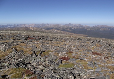
Roughly one-third of a mile from the trailhead, after climbing a series of very steep rock steps, views of the Alpine Visitor Center and Marmot Point begin to emerge towards the west.
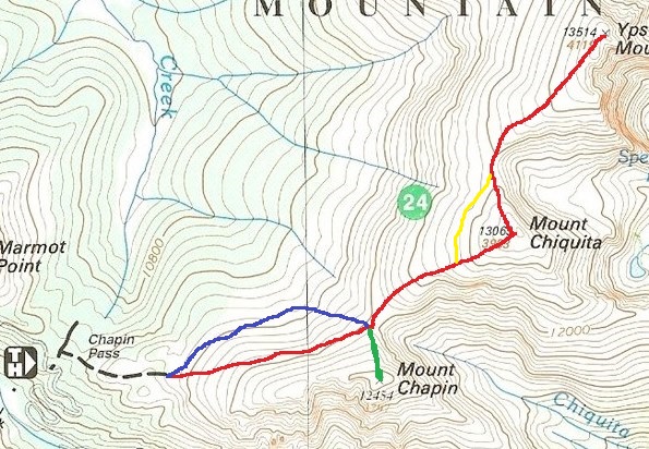
At just over four-tenths of a mile the trail emerges above the treeline, while Chapin, Chiquita and Ypsilon come into view for the first time. At two-thirds of a mile you'll reach another split in the trail. The sign at the junction states that you should turn right to continue towards "all summits". This is the route we took, as indicated by the red line on the map above. The trail to the left is represented by the blue line on the map. Since we could see much of this route during our return trip we concluded that this path might be the better option for reaching the saddle between Chapin and Chiquita.
Beyond the junction the recommended trail (red line) begins to climb the western slopes of Mt. Chapin, and eventually begins to skirt around the northwestern slopes as it proceeds towards the Chapin-Chiquita saddle. As the trail continues you'll traverse through a couple of long talus fields. Although a little rugged, it's not exceedingly difficult. There were a couple of places where it was a little tricky spotting the actual trail, especially with the early sun in our eyes, but it's pretty intuitive as to where to go - you're simply following the contour of the mountain as it makes its way towards the saddle.
At 1.7 miles, just before reaching the saddle, hikers will pass an unmarked side trail. This path leads to the summit of Mt. Chapin (as indicated by the green line on the map above). From this junction you're roughly one-third of a mile and almost 400 feet below the summit of Mt. Chapin. To continue on towards Chiquita you should stay to the left and proceed towards the saddle.
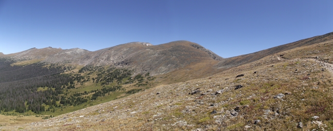
From the saddle the trail climbs steeply, gaining roughly one thousand feet over the next mile before attaining the summit of Mt. Chiquita (see photo on left above). As you climb higher you'll enjoy outstanding views of Longs Peak on your right. Up until the 2.5-mile mark, at an elevation of roughly 12,925 feet, the trail is well defined and easy to follow. Beyond this point, however, route finding becomes a bit more challenging as you begin traversing across boulder and talus fields. Simply look for the most logical way upward, and try to stay on the trail by looking for cairns to help guide the way. If in any doubt, simply continue towards the top. You may want to consider bringing trekking poles for this rugged stretch of terrain.
As you climb these mountains, keep an eye out for bighorn sheep grazing in the tundra areas, or along the rugged east-facing slopes of the mountains.
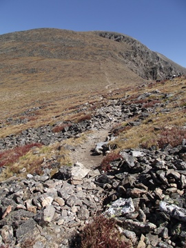
Roughly 2.6 miles from the trailhead hikers will rise above the steepest portion of the entire hike. Looking from far below you will have thought that this was the summit. However, you'll still have a little more than a tenth-of-a-mile to go before reaching the pinnacle. Once you arrive at this point you're going to see what appears to be two summits. Avoid the outcrop towards the right and proceed towards the prominence almost straight ahead.
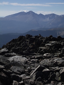
 At just over 2.7 miles hikers will finally reach the summit of Mt. Chiquita. Standing at an elevation of 13,069 feet you'll enjoy outstanding views of Longs Peak towards the southeast, while Ypsilon Mountain rises towards the northeast. This perch will provide a birds-eye view of the snow-filled couloirs that form the Y from which the name of the mountain is derived (Ypsilon is the Greek word for the letter "Y"). Towards the west and southwest you'll be able see Specimen Mountain and all the mountains along the Continental Divide. Just below the east face of the mountain you'll also be able to see Spectacle Lakes, Fay Lakes and Ypsilon Lake.
As previously mentioned, we had a fierce cold wind on the day of our hike. Fortunately there are a couple of manmade rock walls that acted as windbreakers, which allowed us to comfortably refuel for the next leg of our hike.
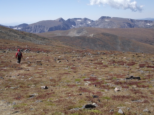
From the summit of Chiquita the route continues by heading downhill towards the saddle between Chiquita and Ypsilon. If there's a trail here, we didn't see it. Traveling along this stretch, however, isn't too bad. It's more grassy tundra than talus rock. Simply follow the most efficient route. The route will drop roughly 290 feet to the saddle before climbing another 735 feet to reach the summit of Ypsilon Mountain.
Once you cross the saddle it's best to stay away from the eastern edge of the mountain. Instead, you should travel a little bit more towards the left where you'll eventually see a faint trail heading directly up the mountain. This will be the most efficient route to the top. To help guide the way you should see some cairns as well.
At roughly 13,350 feet the terrain begins to level out a bit. Off to your right you'll see a prominence that might lead you to believe is the summit; however, you must continue straight ahead to proceed towards higher ground. After traveling another 200 yards or so you'll pass over another false summit. The top of the mountain is still roughly 200 yards away, with another 100 feet or so of climbing remaining.
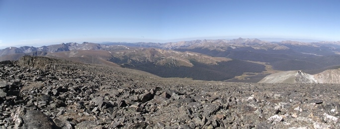
At just over 4.1 miles you'll finally stand atop the 13,514-foot mountain, the 2nd highest mountain in the Mummy Range, and the 5th highest peak in Rocky Mountain National Park. From the top you'll enjoy commanding 360-degree views. From this lofty perch Desolation Peaks will be directly in front of you looking towards the northwest. Towards the northeast is 13,502-foot Fairchild Mountain and 13,560-foot Hagues Peak, and in the valley below are Crystal Lake and Lawn Lake. Looking further out towards the northwest you'll be able to see Long Draw Reservoir, the Snowy Range, and even as far out as the Medicine Bow Range. Towards the west and southwest you'll be able see the Poudre River Valley, Specimen Mountain, the Never Summer Range, as well as the mountains along the Continental Divide. Longs Peak is visible towards the southeast, and towards the south, in the far-off distance well beyond Longs Peak, it appears that the 14,000-foot peaks in the Loveland Pass area are also visible.
Fortunately there are manmade rock walls atop Ypsilon that helped to keep the wind at bay as we soaked-in these incredible views.
As with the ascent, you'll have a couple of options for your descent route. Many people recommended returning via the same route as described above (retracing the red line on the map above). This is recommended because the route is considered by many to be the easiest to follow. We fully intended to take this advice until we began our descent from Ypsilon. From our vantage point (see photo below) it appeared that a straight line track around Chiquita was very doable, thus bypassing the climb up the mountain for a second time. Once we returned to the saddle we stayed towards the right and began following that contour around to the west side of Chiquita (yellow line on the map above). Hikers should resist the temptation to drop in elevation, and try to hold the same elevation as the saddle. The slopes along this contour line are mostly grassy tundra. Further downhill you'll run into more talus fields, thus making travel and navigation much more difficult. We did find a very faint trail which helped a great deal. Eventually you'll meet-up with the main trail along the southwestern side of the mountain. I would definitely recommend taking this route as long as you feel comfortable with route finding and walking off trail. Whether you take this route or not, it's still a good idea to carry a topographic trail map.
Hikers should always be aware of lightning risk while hiking in the Rocky Mountains, especially at the higher elevations. As a general rule of thumb you should plan to be off the summit before noon in order to avoid the notorious afternoon thunderstorms that frequent the mountains during the summer months. Hikers should also be prepared for extreme sun exposure, wind, cool temperatures, and rapidly changing weather conditions while on the trail. Make sure you have the proper gear with you, and know what safety precautions you need to consider beforehand. On this route you'll be exposed to the elements for several hours.
If planning to hike this route before early July you should definitely inquire with a ranger about snow conditions before attempting your hike. You'll also want to make sure that Old Fall River Road is open. Finally, you should also make sure that you're fully acclimated to altitude before attempting this route.