
Black Face Mountain
| Trail Features: | Outstanding Panoramic Views, Wildflowers | 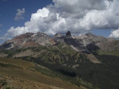 |
|||
| Trail Location: | Lizard Head Pass (near Telluride) | ||||
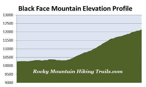
| Roundtrip Length: | 7.8 Miles | ||||
| Trailhead Elevation: | 10,245 Feet | ||||
| Total Elevation Gain: | 1950 Feet | ||||
| Avg. Elev Gain / Mile: | 500 Feet | ||||
| Highest Elevation: | 12,147 Feet | ||||
| Trail Difficulty Rating: | 11.70 (strenuous) | ||||
| Parking Lot Latitude | 37.81253 | ||||
| Parking Lot Longitude | -107.90847 | ||||
Trail Description:
The hike to the summit of Black Face Mountain begins from the top of Lizard Head Pass near Telluride, Colorado. To reach the pass, drive south from the traffic circle near Telluride on Colorado Highway 145 for 11.7 miles. On the right (west) side of the highway is a large rest area. Although you can access the trail from the northeast corner of the parking area, the official trailhead is located in a smaller lot immediately above the main parking area. Simply drive through the large parking area, past the restroom, and turn right to access the Lizard Head Trailhead parking lot.
The hike begins by traveling northeast through an open grassy field for almost a half-mile before entering the canopy of a thick spruce-fir forest. Eventually the trail begins passing through a long stretch of mature aspen groves, making this an excellent choice for a fall hike.
At 1.6 miles hikers will enter the Lizard Head Wilderness. Up to this point the Lizard Head Trail has mostly traveled over a gentle grade, with a few mild undulations along the way. This portion of the trail more or less follows along the contours above Highway 145. After passing the wilderness boundary, however, the trail begins to ascend along the eastern slopes of Black Face Mountain, while traveling away from the highway. After ascending a series of switchbacks views of Trout Lake in the valley below begin to open up.
As we climbed higher, while passing along the periphery of forest and talus meadows, we saw two hawks chasing each other. A little further up the trail we also heard the scream of an eagle soaring high above us.
At just over 2.25 miles hikers will reach the side trail that leads to Wilson Meadows, which you'll be able to see from the summit of Black Face Mountain. The trail is 1.4 miles in length, but it's an easy walk of only three-quarters of a mile to reach the outskirts of the meadow, and makes for another outstanding destination if you have the time and energy. To continue towards Black Face Mountain you should stay left at this junction and proceed upward along the Lizard Head Trail.
At just over 3 miles the trail more or less emerges above the canopy of the old growth pine forest, and begins traversing along the eastern ridge of Black Face Mountain. From this point the grade moderates considerably. This section of trail is famous for its summer wildflowers. During our late-August hike most of the flowers were already spent, though we still saw a fair amount. As you continue towards the summit the views of the surrounding mountains and valleys become progressively more expansive.
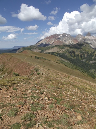
Hikers will begin the final push towards the summit roughly 3.5 miles from the trailhead. You may want to note that there are a couple of false summits along this stretch. This section of trail is also very easy to navigate, and there really aren't any issues with exposure to steep drop-offs, as long as you stay on the trail. As you push higher the meadows along the ridge eventually give way to alpine tundra.
At roughly 3.9 miles you'll finally stand atop Black Face Mountain. I've often said that the San Juan Mountains could easily qualify as a national park, and if included, would definitely rank as one of the crown jewels in the entire national park system. Hiking to the 12,147-foot summit of this mountain will definitely show you why - the 360-degree views from the top are absolutely stunning.
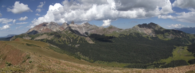
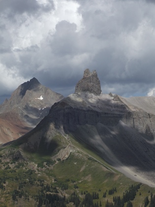
Towards the east and southeast are several 13ers that rise above the Lizard Head Pass area, including Pilot Knob, Golden Horn, Vermillion, Beattie and San Miguel Peak. To the north, 12,930-foot Sunshine Mountain rises above Wilson Meadows. Towards the northeast are the most impressive and dramatic mountains visible from the summit. You'll be able to see 14,252-foot Mt. Wilson, 13,913-foot Gladstone Peak, and 14,017-foot Wilson Peak. These mountains form the backdrop for the Lizard Head, the prominent 13,113-foot volcanic spire of crumbling rock that inspired the name for the trail and the wilderness area.
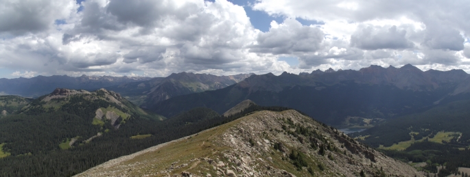
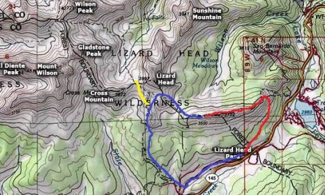
Our original intent was to make this a loop hike, however, with dark clouds building rapidly we thought it would be far more prudent to turn around and return to the trailhead as quickly as possible. The loop version of this hike continues down the western ridge of Black Face Mountain until reaching the Cross Mountain Trail (represented by the blue line in the map below). This could include a side trip to the Bilk Basin Overlook (represented by the yellow line). The Cross Mountain Trail will lead you back towards the highway, at which point you would return to Lizard Head Pass using an old railroad grade route. This loop is roughly 12.2 miles in length, and includes roughly 2700 feet in total elevation gain.
Hikers should always be aware of lightning risk while hiking in the Rocky Mountains, especially at higher elevations. As a general rule of thumb you should plan to be off the summit before noon in order to avoid the notorious afternoon thunderstorms that frequent the mountains during the summer months. Hikers should also be prepared for extreme sun exposure, wind, cool temperatures, and rapidly changing weather conditions while on the trail. Make sure you have the proper gear with you, and know what safety precautions you need to consider beforehand.