Blue Lakes
| Trail Features: | Outstanding Views, Lakes, Wildflowers | 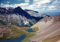 |
|||
| Trail Location: | Blue Lakes Trailhead (#201) | ||||
| Roundtrip Length: | 8.6 Miles | ||||
| Trailhead Elevation: | 9350 Feet | ||||
| Total Elevation Gain: | 2370 Feet | ||||
| Avg. Elev Gain / Mile: | 551 Feet | ||||
| Highest Elevation: | 11,720 Feet | ||||
| Trail Difficulty Rating: | 13.34 (strenuous) | ||||
| Parking Lot Latitude | 38.035759 | ||||
| Parking Lot Longitude | -107.806825 | ||||
Trail Description:
Is it possible to sense that you're being watched by a mountain lion?
The first time I hiked to Blue Lakes was in 1997, which was also one of the first times I ever went hiking with my future wife. We had known each other for almost a year when we decided to do a hiking trip in the Ouray area. We were roughly 1.5 miles from the Blue Lakes Trailhead, just past the point where the trail enters the Mt. Sneffels Wilderness area, when I had the distinct feeling that we were being watched…presumably by a mountain lion. I didn't feel threatened, nor that we were being stalked, but just had an eerie feeling. I didn't want to say anything to Kathy for fear of making her unnecessarily nervous, especially with regards to something that could be completely unfounded.
It wasn't until we returned back to the trailhead several hours later that I relayed my story to Kathy. Surprisingly, she also had that same feeling - in that exact same spot. It was the first time, and the only time, that either of us has ever felt like we were possibly being watched by a predator. Perhaps it was nothing, or maybe we were passing through the territory of a mountain lion. Who knows?
The Blue Lakes are located in an extremely scenic glacial basin within the 16,566-acre Mt. Sneffels Wilderness area of the Uncompahgre National Forest. The drive to the trailhead is quite spectacular as well. It offers outstanding panoramic views of Mt. Sneffels and the Dallas Creek drainage area. It's especially beautiful in the fall when the aspens turn to yellow and gold.
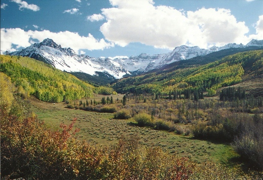
The trailhead is located off CO Highway 62 between Ridgway and Telluride. From the highway, turn south onto Dallas Creek Road (CR 7 / FR 851) and drive 9 miles to the trailhead (Please note: although the dirt/gravel road was passable for 2WD vehicles in the past, as of 2022 it's no longer advisable to attempt this in a 2WD vehicle until the road is regraded. You may want to contact the county or the Forest Service for updates). The hike begins just beyond the locked gate at the end of the road.
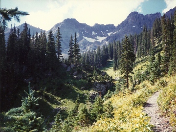 Just beyond the gate hikers will pass the Blaine Basin Trail junction, which branches off towards the east. Hikers should continue on the Blue Lakes Trail, which heads in a southwesterly direction while following along the East Fork of Dallas Creek.
From here the trail climbs steadily up the valley between Mt. Sneffels and 13,041-foot Wolcott Mountain. The early portions of the route wanders in and out of Engelmann spruce forests, while providing expansive views of the Sneffels Range in the open areas.
At roughly 1.5 miles from the trailhead the path crosses a small stream, and then begins heading towards the southeast as it makes the final climb up to Blue Lakes.
Roughly 3.5 miles from the trailhead hikers will arrive at Lower Blue Lake, which sits at an elevation of 10,980 feet, and is the largest of the three lakes. From the western shore you'll have a commanding view of Mt. Sneffels towering above the lake.
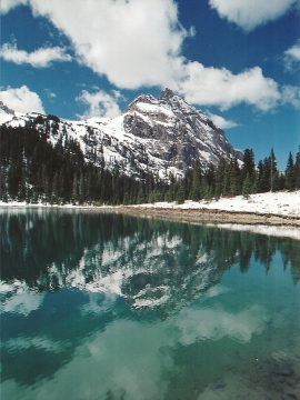 At 14,150 feet Mt. Sneffels ranks as the 27th highest peak in Colorado. It also ranks as the third highest peak in the incredibly beautiful San Juan Mountain range of southwestern Colorado. It was named by Frederic Endlich during the 1874 Hayden Expedition because he thought it had a striking resemblance to Mount Snaefell in Jules Verne's "Journey to the Center of the Earth".
There are several campsites located in the lower lake vicinity (there are campsites near the trailhead as well). Many people use this area as a base camp for their climb to the summit of Mt. Sneffels.
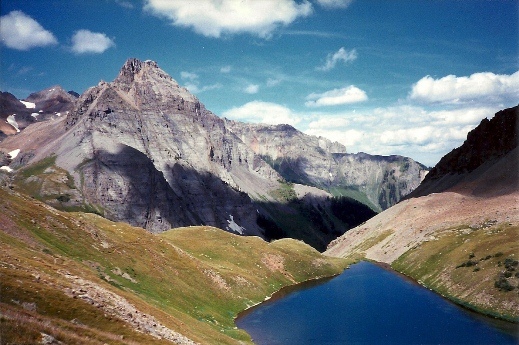
Although the views are very nice here, the upper lakes provide far more scenic panoramas.
From the lower lake the trail begins to climb again. Hikers will ascend more than 500 feet in a little over a half-mile to reach the middle lake at 11,500 feet. The Upper Blue Lake is a little more than a quarter-mile beyond, and sits at an elevation of 11,720 feet. Here you'll enjoy outstanding views of Mt. Sneffels, as well as 13,809-foot Dallas Peak and 13,694-foot Gilpin Peak looking towards the south.
The area surrounding the three lakes offers a profusion of wildflowers in the summer. Once the winter snow melts hikers may see blue columbine, purple larkspur, lupine, Indian paintbrush, alpine avens, red queen's crown and pink moss campion. The best times for viewing wildflowers are usually from around mid-July through mid-August.
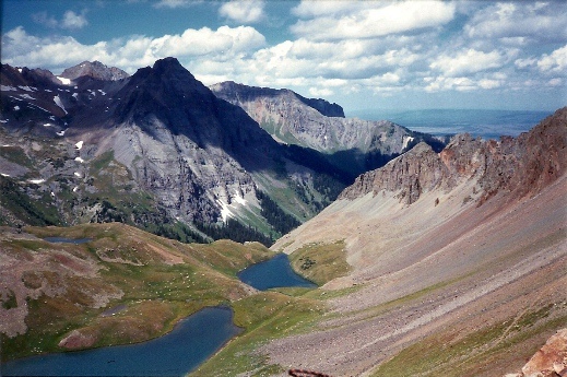
From here the Blue Lakes Trail continues up to Blue Lakes Pass (at roughly 13,000 feet), before descending into Yankee Boy Basin. If you have the energy I highly recommend continuing for at least another quarter-mile or so, beyond the upper lake, to soak in the grand view of all three lakes. From above the views are simply stunning. Hikers should note, however, as you proceed higher the route becomes extremely steep, and has some very steep drop-offs alongside the fairly narrow path.
If you're considering making the climb to the summit of Mt. Sneffels you should note that the last couple hundred feet to the top is characterized by loose volcanic rock and eroded sections of trail, making this more of a mountaineering route than a hike. I highly recommend reading Gary Roach's Colorado Fourteeners guide before attempting this route.
The hike to Blue Lakes is one of my all-time favorite hikes. I would have to rate this as good as any of the best hikes in the best national parks around the country.
Additional Resources:
* Trails Illustrated Map for Silverton, Ouray, Telluride and Lake City - includes the Blue Lakes Trail