Boulder Brook Loop
| Trail Features: | Waterfalls, Scenic Views, Fall Aspens | 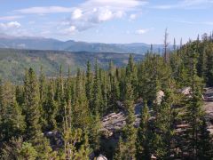 |
|||
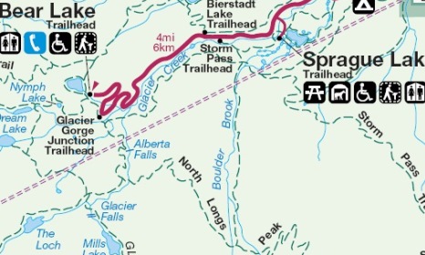
| Trail Location: | Storm Pass Trailhead | ||||
| Roundtrip Length: | 8.6 Miles | ||||
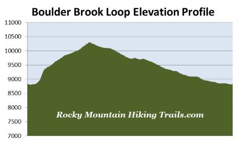
| Trailhead Elevation: | 8830 Feet | ||||
| Total Elevation Gain: | 1510 Feet | ||||
| Avg. Elev Gain / Mile: | 351 Feet | ||||
| Highest Elevation: | 10,310 Feet | ||||
| Trail Difficulty Rating: | 11.62 (strenuous) | ||||
| Parking Lot Latitude | 40.31995 | ||||
| Parking Lot Longitude | -105.61996 | ||||
Trail Description:
The Boulder Brook Loop in Rocky Mountain National Park begins from the Storm Pass Trailhead, located on Bear Lake Road roughly 6.4 miles from the turn-off at Highway 36. The trailhead is located on the left side of the road, between Sprague Lake and the Bierstadt Lake Trailhead. There’s room for 4 or 5 cars in this very small parking area. However, if the lot is full you can park at the much larger lot at the Bierstadt Lake Trailhead, located just over a tenth-of-a-mile up the road. There’s a social trail on the south side of Bear Lake Road that you can follow back to the Storm Pass Trailhead, thus avoiding a walk on the road.
Although you can hike in either direction, we chose to hike in a clockwise direction. This allowed us to more easily see the waterfalls as we ascended the Boulder Brook Trail, while also allowing us to more easily see the mountain scenery while descending the North Longs Peak Trail.
The hike begins in a grassy meadow that offers commanding views of the mountains along the Continental Divide. However, after walking roughly one hundred yards, the trail crosses over Glacier Creek and immediately heads into the woods. At roughly one-third of a mile from the trailhead you’ll arrive at a junction. The trail leading to the left will take you to Sprague Lake. Hikers should proceed straight ahead to continue towards the Boulder Brook Trail.
 At roughly one-half mile you’ll reach a somewhat confusing trail junction. The Glacier Creek Trail crosses over the main trail here. You’ll effectively want to proceed straight ahead here to continue on towards the Boulder Brook Trail. After walking a very short distance you’ll see the Boulder Brook “trailhead” sign.
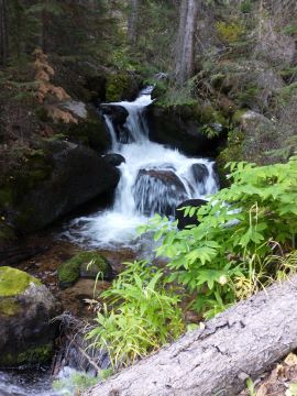
Just beyond this junction the trail begins to climb steeply, while passing through a fairly thick aspen forest. After walking a short distance you’ll finally make contact with Boulder Brook for the first time. Over the next four-tenths of a mile the trail climbs very steeply – easily exceeding a 20% grade in some sections. Fortunately, the trail is very easy to navigate. Though technically it’s considered to be an unimproved trail, there are no dangerous drop-offs, while the steepness allows for constant cascades and waterfalls as the stream tumbles down the mountain.
Boulder Brook begins its relatively short journey in the Boulder Field below Longs Peak, before emptying into Glacier Creek near Sprague Lake. The brook is known for its rushing waters during the spring runoff. Unfortunately for early season hikers, all this water attracts mosquitos, which are known to be pretty thick in the spring and early summer.
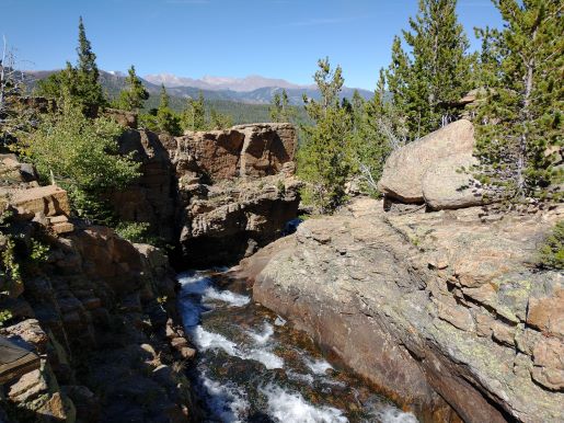
After crossing the third and final footbridge over Boulder Brook the trail begins to move away from the stream, while continuing to climb towards Longs Peak. At roughly 1.7 miles from the trailhead you’ll notice that the tree canopy has begun to thin. Here you’ll enjoy a nice view of Longs Peak and the mountains along the Continental Divide.
 Although the Boulder Brook Trail is lightly used by humans, the route appears to be fairly popular with some of the larger wildlife in the park, judging by the amount of scat we saw on the trail. We noticed several instances of what appeared to be bear scat, as well as either canine (coyote or fox) and/or feline (bobcat, lynx or cougar) scat.
At roughly 2.25 miles hikers will pass the spur trail leading to Boulder Brook Backcountry Campsite #2, and shortly thereafter, Campsite #1.
At 2.6 miles hikers will finally arrive at the North Longs Peak Trail junction. A turn to the left here will lead to Granite Pass, located roughly 3.3 miles away. To continue on the loop hikers should turn right here. The remainder of this hike is almost completely downhill from this junction.
Just beyond the junction the trail crosses over a tributary of Boulder Brook. It appears there was a fairly major flash flood here in recent years, as there are lots of downed trees and upturned stones in this vicinity. From the footbridge the North Longs Peak Trail travels downhill at a fairly rapid pace. Hikers will enjoy sporadic views of the surrounding mountains and the Bear Lake Road corridor throughout this section.
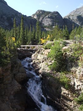
At roughly 4.75 miles the trail crosses over Glacier Creek near a small, but spectacular gorge. You’ll also enjoy some great views of the mountains across the valley. This is a great spot for an extended break.
At 4.9 miles hikers will reach the Glacier Creek Trail junction. You should turn right here to continue on this loop hike. Over the next 1.3 miles you’ll travel along one of the busiest trails in the park. This section includes Alberta Falls, which you’ll pass at roughly 5.7 miles from the trailhead.
At roughly 6.25 miles you’ll arrive at the Bear Lake Trailhead split. You should turn right to continue on the loop. After walking another 30 yards or so you’ll arrive at the Glacier Gorge Trailhead split. You should turn right once again to continue along the Glacier Creek Trail towards the Storm Pass Trailhead. From this junction the trail once again begins traveling on a lightly used path. This leg of the trip passes through a pleasant aspen and pine forest.
At 8.3 miles you’ll reach the final leg of the loop. Simply take a left to return back to the trailhead at this junction.