Chasm Falls
| Trail Features: | Waterfalls | 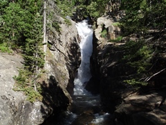 |
|||
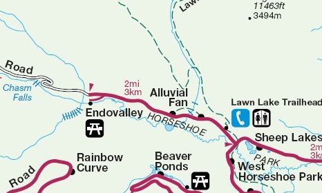
| Trail Location: | Endovalley Picnic Area | ||||
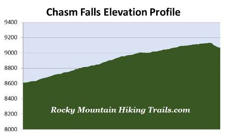
| Roundtrip Length: | 2.8 Miles | ||||
| Trailhead Elevation: | 8610 Feet | ||||
| Total Elevation Gain: | 585 Feet | ||||
| Avg. Elev Gain / Mile: | 418 Feet | ||||
| Highest Elevation: | 9131 Feet | ||||
| Trail Difficulty Rating: | 3.97 (easy) | ||||
| Parking Lot Latitude | 40.41388 | ||||
| Parking Lot Longitude | -105.65672 | ||||
Trail Description:
This hike to Chasm Falls in Rocky Mountain National Park begins from the Endovalley Picnic Area in Horseshoe Park, located just west of Estes Park. To reach the trailhead drive 2.1 miles past the Fall River Entrance Station on Highway 34 and turn right onto Endovalley Road. From this junction drive another 1.7 miles to the Endovalley Picnic Area, located just before reaching the one-way, Old Fall River Road. Simply find a parking space in the picnic area and walk back out to Old Fall River Road. The falls are located roughly 1.4 miles up the road.
During the short summer season when Old Fall River Road is open (usually from around late June to around late September), hikers will have the choice of driving to the Chasm Falls Trailhead. However, this will commit you to driving the entire length of the one-way, gravel road up to the Alpine Visitor Center on Trail Ridge Road. You should check the park website to make sure the road is open before commiting to this option. As you might expect, if you decide to walk up the road you'll have to watch for traffic. Since this is a fairly popular hike, parking at the trailhead, or even in the Endovalley Picnic Area, can be a problem at certain times. Hikers will also have the option of parking in the West Alluvial Fan Parking Area, located roughly 0.7 miles from the Endovalley Picnic Area.
 From the picnic area hikers will proceed up Old Fall River Road. This historic "motor nature trail" was opened in 1920, and was the first road to cross over Rocky Mountain National Park. It preceded Trail Ridge Road by twelve years. The narrow 11-mile road tops out 11,796 feet above sea level at Fall River Pass, near the Alpine Visitor Center on Trail Ridge Road.
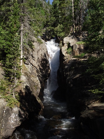
After walking almost one mile the road makes a sharp switchback towards the east. Hikers will travel another tenth-of-a-mile before the road makes another sharp switchback towards the west. At just under 1.4 miles hikers will reach the Chasm Falls Trailhead, which is marked by a sign. Simply walk the short distance down the paved footpath to the viewing area. From the viewing platform you can comfortably watch the falls as they crash through a narrow granite chasm. Dropping roughly 25 feet, Chasm Falls is arguably one of the most spectacular waterfalls in the park.
As we admired the beauty of the falls on our most recent hike, we noticed two American dippers feeding in the pools below the falls. These small, slate-grey colored birds, also known as water ouzels, are known for bobbing, or "dipping" along the rocks around fast moving streams, and diving under water in search of food. Once below the surface of the water the dippers forage by either walking along the stream bottom, or by "flying" through the water, using their wings to propel themselves through the swift currents.