
Chasm Lake
| Trail Features: | Alpine Lake, Outstanding Panoramic Views | 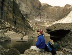 |
|||
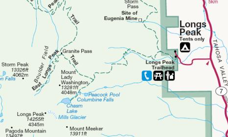
| Trail Location: | Longs Peak Ranger Station | ||||
| Roundtrip Length: | 8.5 Miles | ||||
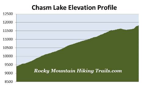
| Trailhead Elevation: | 9405 Feet | ||||
| Total Elevation Gain: | 2500 Feet | ||||
| Avg. Elev Gain / Mile: | 588 Feet | ||||
| Highest Elevation: | 11,823 Feet | ||||
| Trail Difficulty Rating: | 13.50 (strenuous) | ||||
| Parking Lot Latitude | 40.27215 | ||||
| Parking Lot Longitude | -105.55682 | ||||
Trail Description:
The hike to Chasm Lake in Rocky Mountain National Park begins from the Longs Peak Trailhead. To reach the trailhead from Estes Park, drive 8.9 miles south along Colorado Highway 7 to the turnoff for the Longs Peak Ranger Station. From the turnoff drive another mile to the ranger station. Please note that parking is fairly limited, and the lot fills up very early on weekends. Additional parking is available along the roadside leading up to the trailhead, but is also quite limited. You may also want to note that car-camping is not allowed in the parking area.
Due to the popularity of the hikes from this trailhead, the length of time it takes to reach most destinations, exposure to afternoon thunderstorms, and limited parking, you'll definitely want to arrive as early in the morning as possible, especially on weekends during the summer months. Day hikers planning to summit Longs Peak usually arrive between 3 a.m. and 5 a.m.
Starting at an elevation of roughly 9405 feet, hikers will follow the East Longs Peak Trail for much of this hike.
Longs Peak is the highest point in Rocky Mountain National Park. The 14,259-foot peak is named after Major Stephen H. Long, who led an expedition across the Great Plains and along the base of the Rockies in 1820. While out on the plains, in the distant view, the expedition could see the highest mountain in the northern range. Although they never entered Rocky Mountain National Park, three members of the expedition would later become the first to climb Pikes Peak.
 John Wesley Powell, along with several others including William Byers, the founder of Rocky Mountain News, would make the first ascent of Longs Peak in 1868. Powell, the one-arm Civil War Major, would also become the first person to float the Colorado River through the Grand Canyon.
From the Longs Peak Ranger Station the trail begins a steep climb through a thick forest of lodgepole pine, spruce and fir. Roughly one-half mile from the trailhead hikers will reach the Eugenia Mine Trail junction, and at 1.2 miles will pass the short side trail that leads to the Goblins Forest Backcountry Campground (containing six individual campsites).
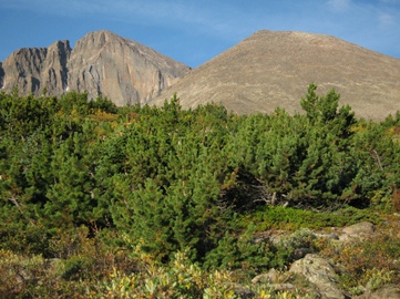
Roughly 2.2 miles from the trailhead, and an elevation of approximately 10,750 feet, hikers will emerge from the forest and enter the subalpine zone. Dominating the landscape along this stretch of trail is krummholz, a German word that means twisted wood, which describes the stunted and irregular growth patterns of trees found in the transition zone between forest and tundra. Mount Meeker, Longs Peak and Mt. Lady Washington will also come into view at this point.
 At just over 2.5 miles you'll reach the spur trail that leads to the Battle Mountain Backcountry Campsite (contains one group site). Beyond the junction the main trail leaves the subalpine zone and begins to ascend Mills Moraine. Most hikers will likely benefit from the use of trekking poles as they travel along this rugged stretch of terrain.
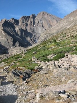
At roughly 3.4 miles, and an elevation of 11,540 feet, hikers will arrive at the Chasm Lake Trail junction. From this point 13,281-foot Mt. Lady Washington will be the dominating feature towards the west. If needed, an outhouse is located here as well.
From the junction the Chasm Lake Trail travels southwest along the wall of a deep gorge that offers birds-eye views of Peacock Pool and Columbine Falls as you proceed towards the lake. Compared to the East Longs Peak Trail, the grade along this stretch of trail is much more moderate. After skirting along the wall of the gorge the trail eventually passes over the top of the waterfall before emerging onto a small alpine basin.
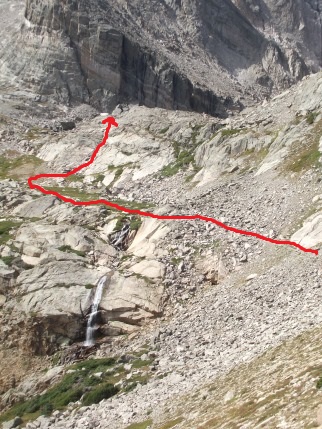
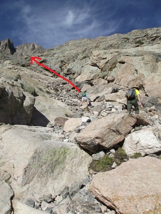
After a brief walk through the basin the trail begins to climb sharply up the headwall that forms Chasm Lake. This section of trail requires a little bit of route finding, as well as some easy rock scrambling. Although there are cairns that follow different routes up this section, your most efficient route will likely be towards the right, heading almost straight up the draw. This stretch of “trail” ascends for roughly one-tenth of a mile to reach the top of the wall where you'll finally enjoy your first view of Chasm Lake. The two photos below give an indication of where the route travels. In the photo on the left you can see the trail as it passes above Columbine Falls before ascending the headwall. The photo on the right provides a close-up view from the bottom of the draw:
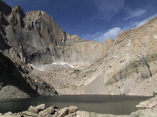
Chasm Lake sits in a deep cirque at the base of Mount Lady Washington towards the north, and Longs Peak towards the west. The famous east-facing wall of Longs Peak, known as the "Diamond", rises more than 2,400 feet above this incredibly stunning and dramatic alpine lake. Looking towards the south is 13,911-foot Mount Meeker. The Keyboard of the Winds is also visible from this vantage point. The stunning scenery that surrounds the lake easily makes this one of the best hikes in Rocky Mountain National Park.
Much of the shoreline around the lake is accessible; however, some minor rock scrambling is required to reach some of the better vantage points. The national park website provides additional information on hiking in the Longs Peak area, as well as some general hazards you should be aware of while hiking in the high country. You should always be aware of lightning risk while hiking in the Rocky Mountains, especially at higher elevations. You should also be prepared for extreme sun exposure, wind, cool temperatures, and rapidly changing weather conditions while on the trail. Make sure you have the proper gear with you, and know what safety precautions you need to consider beforehand.
If you still have the energy, plenty of time, and good weather, you'll have the option of continuing on to Battle Mountain, the Boulder Field or the Keyhole.