
Crater Lake
| Trail Features: | Outstanding Views, Wildflowers, Fall Aspens | 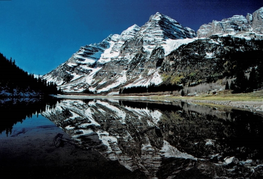 |
|||
| Trail Location: | Maroon Bells Scenic Area | ||||
| Roundtrip Length: | 3.6 Miles | ||||
| Trailhead Elevation: | 9565 Feet | ||||
| Total Elevation Gain: | 690 Feet | ||||
| Avg. Elev Gain / Mile: | 383 Feet | ||||
| Highest Elevation: | 10,158 Feet | ||||
| Trail Difficulty Rating: | 4.98 (easy) | ||||
| Parking Lot Latitude | 39.098595 | ||||
| Parking Lot Longitude | -106.94065 | ||||
Trail Description:
The hike to Crater Lake begins from the Maroon Bells Scenic Area, located at the end of Maroon Creek Road (CR 13) roughly 10 miles southwest of Aspen. Hikers should note that this is an extremely popular area. In fact, the Maroon Bells are said to be among the most photographed mountains in North America. As a result, a shuttle or parking reservation is now required for most visitors from mid-May through October. For more information you should visit aspenchamber.org.
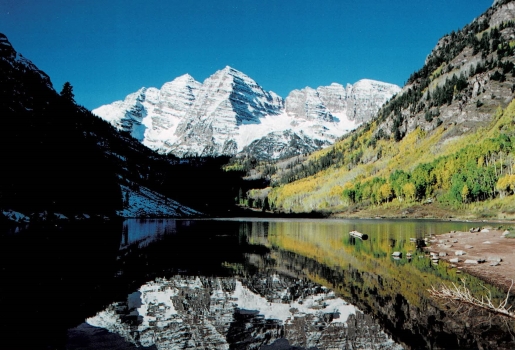
From the main parking area the Maroon-Snowmass Trail (#1975), also referred to as the Crater Lake Trail, travels only a short distance to reach the foot of Maroon Lake. From its northeastern shore you’ll enjoy one of the most iconic views in America. At the far end of the valley 14,163-foot Maroon Peak and 14,019-foot North Maroon Peak, collectively known as the Maroon Bells, rise above the lake like the Pyramids of Giza. It’s a striking and dramatic scene that’s difficult to truly capture in a photograph, especially if there’s snow on the mountains, or when the aspens have turned to brilliant hues of yellow and orange in the fall.
After soaking in the majestic views hikers will continue towards Crater Lake by following the trail around the north end of Maroon Lake. At roughly three-tenths of a mile from the trailhead you’ll arrive at the Maroon Lake Trail junction. This scenic trail continues to skirt around the west end of the lake before heading southwest to make a loop around a small beaver pond. To continue towards Crater Lake you should stay to the right at this junction.
 Just beyond the junction the trail begins to pass through an aspen forest. During brief intervals when the canopy opens, 14,026-foot Pyramid Peak will dominate the view towards the south.
At roughly one-half mile hikers will reach the Maroon-Snowmass Wilderness boundary. Also located here is a connector trail that leads to the aforementioned Maroon Lake Trail, which branches off to the left at this junction. If you still have the time and energy on your return trip you can use this trail to access the scenic loop. This will add roughly one mile to your overall mileage.
Beyond the junction the trail begins to ascend towards the saddle between Pyramid Peak and Peak 12,942. As you climb higher the footpath becomes noticeably rockier, while the aspens eventually give way to a spruce-fir forest. At roughly one mile from the trailhead there’s an opening in the canopy that provides an outstanding view of Maroon Lake.
At just under 1.6 miles the trail tops out along the boulder-strewn saddle between Pyramid Peak and Peak 12,942. Shortly thereafter, as the trail makes the quick descent down to Crater Lake, hikers will arrive at the West Maroon Trail junction. The Maroon-Snowmass Trail continues to the right, and eventually leads to Buckskin Pass. The West Maroon Trail leads to Crater Lake and West Maroon Pass. This junction also marks the starting point for the so-called Four Pass Loop, an epic backpacking trek of at least 23 miles from this point, dependent on which route options you choose along the way. Hikers should proceed to the left here to continue towards Crater Lake, which is located roughly one-tenth of a mile from this junction.
From the northern shore of Crater Lake the views of the Maroon Bells, which rise directly above the lake towards the southwest, are stunning and awe-inspiring. Towering above the southeastern shore is Pyramid Peak. These three fourteeners rank as the 2nd, 5th and 6th highest peaks in the Elk Mountain Range. Early morning hikers may have the opportunity to go home with some great photos of these peaks reflecting off the lake during calm weather. Hikers may want to note that the lake normally has a surface area of 25 acres, but the shallow southern end tends to dry up in the late summer, which creates a large mudflat.
If you wish to explore more terrain in this area the trail continues to loop around the west side of the lake. It travels across a broad valley for nearly three-quarters of a mile before beginning its long ascent towards West Maroon Pass.
Additional Resources:
* Trails Illustrated Map for the Maroon Bells, Elk Mountains, Raggeds Wilderness & White River NF