Four Lakes Loop
| Trail Features: | Outstanding Lake Views, Waterfalls | 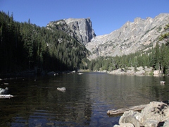 |
|||
| Trail Location: | Bear Lake Trailhead | ||||
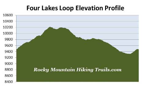
| Roundtrip Length: | 5.6 Miles | ||||
| Trailhead Elevation: | 9475 Feet | ||||
| Total Elevation Gain: | 1030 Feet | ||||
| Avg. Elev Gain / Mile: | 368 Feet | ||||
| Highest Elevation: | 10,240 Feet | ||||
| Trail Difficulty Rating: | 7.66 (moderate) | ||||
| Parking Lot Latitude | 40.31196 | ||||
| Parking Lot Longitude | -105.64581 | ||||
Trail Description:
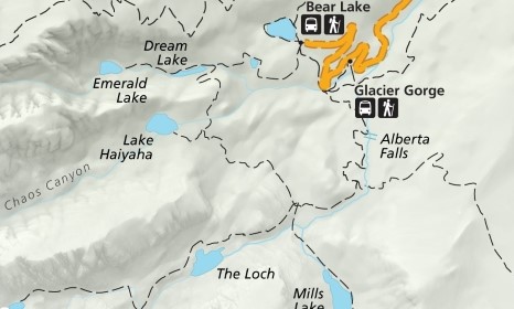
The so-called "Four Lakes Loop" in Rocky Mountain National Park begins from the Bear Lake Trailhead, located at the end of Bear Lake Road, 9 miles from the turn-off at Highway 36. This loop hike visits Bear Lake, Nymph Lake, Dream Lake and Lake Haiyaha, as well as Alberta Falls. Due to the extreme popularity of the area you may want to consider using the free park shuttle to reach the trailhead during peak tourist season. Hikers will also have the option of starting this hike from the Glacier Gorge Trailhead. This, however, will add almost six-tenths of a mile to your overall mileage.
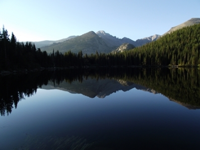 Just a few steps beyond the Bear Lake Trailhead the Bear Lake Loop splits off to the right, while the trail to Nymph Lake continues towards the left. If starting in the early morning you might have the opportunity to go home with some great photos of Hallett Peak reflecting off the water from the east shore, or Longs Peak from the north shore of Bear Lake. If wishing to avoid the crowds that flock to this extremely popular area I highly recommend starting in the early morning anyway. If you decide to hike the entire Bear Lake Loop it will add roughly 0.8 miles to your overall mileage.
After visiting Bear Lake the trail begins a steady climb up to Nymph Lake. Every now and then you'll catch a glimpse of Longs Peak through the canopy of the trees. Due to the heavy amount of foot traffic this area receives, much of this section of trail has been paved.
At just over a half-mile from the trailhead hikers will reach the south end of Nymph Lake, a pleasant lake ringed by pond lilies. If you continue up the trail for a short distance you'll have a nice view of Hallett Peak standing sentinel over the small pond.
As you proceed around the lake you'll encounter a fairly steep climb for a short stretch that includes a great view of Longs Peak and the Keyboard of the Winds to your left. Continuing higher will provide spectacular views of Hallett Peak as well. This section of trail, between Nymph Lake and Dream Lake, also offers an abundance of wildflowers during the summer.
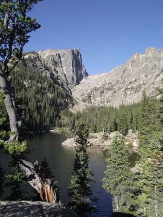 At roughly 1.1 miles from the trailhead hikers will arrive at a junction. A turn to the right here will lead you to the foot of Dream Lake, located roughly 100 yards past the junction. The views of 12,713-foot Hallett Peak and 12,324-foot Flattop Mountain from the east shore of this beautiful subalpine lake are truly exceptional. In between the two mountains is the Tyndall Gorge, with the Tyndall Glacier just barely visible from this angle.
If you wish to explore more of the Tyndall Gorge area you'll have the option of continuing along this same trail for another two-thirds of a mile to visit Emerald Lake, another incredibly beautiful subalpine lake. To continue on the loop you should return to the trail junction and begin heading southbound, towards Lake Haiyaha, the fourth and final lake on this loop.
From the split the trail begins a fairly steep climb through a dense pine forest. At roughly 1.3 miles you'll reach an opening in the canopy that offers commanding views of the Glacier Basin area, including views of Bear Lake, Nymph Lake and even Bierstadt Lake in the far off distance. From this point the trail begins to level out.
At roughly 1.7 miles you'll reach the side trail that leads to Lake Haiyaha. Hikers should proceed straight ahead (to the right) to visit this lake. From the junction travel will be quite easy as you approach the lake. However, the last 50 yards to the shore becomes quite rugged. Hikers will have to negotiate through some large boulders, nothing too difficult, but something you'll have to take your time to get through. As you pass through this section be sure to check out the old twisted pine growing among the boulders. Some of the oldest trees in the park are said to be located around this lake.
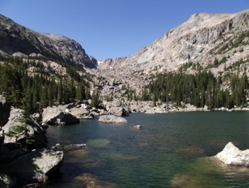 As you will have already discovered by this point, the shoreline is quite rugged, with large boulders surrounding the entire lake - the result of it lying in the heart of Chaos Canyon. The scene at Lake Haiyaha is simply stunning. Dominating the view, looking almost straight across the lake, is 12,486-foot Otis Peak on your left, and Hallett Peak towards the right. In between the two mountains is the appropriately named Chaos Canyon. On your far left you can even see The Sharkstooth.
"Haiyaha" is a Native American word that means "rock" or "lake of many rocks", or "big rocks", depending on the translation.
To continue along the loop you'll have to retrace your steps back to the trail junction, turn right, and begin traveling down towards Mills Junction.
This next section of trail was rehabilitated by the National Park Service and the Rocky Mountain Conservancy as part of a major, multi-year project to make this formerly unimproved route safer and easier to follow.
 At roughly 3.4 miles hikers will reach Mills Junction. The loop hike continues by turning left and heading towards Alberta Falls. From this junction hikers will also have the option of visiting The Loch, which is roughly seven-tenths of a mile away, or Mills Lake, which is roughly one-half mile away.
At 3.9 miles you'll arrive at the North Longs Peak Trail junction. To continue towards your destination you should veer towards the left here.
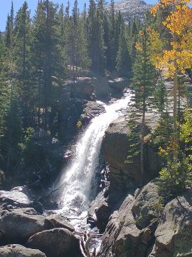
At just over 4.6 miles hikers will reach Alberta Falls, one of the more popular hiking destinations in Rocky Mountain National Park. This scenic 30-foot waterfall thunders down a small gorge on Glacier Creek, and is named after Alberta Sprague, the wife of Abner Sprague, one of the original settlers in the Estes Park area.
From the waterfall the trail continues to descend until reaching the Glacier Creek Trail junction, located at roughly the 5.2-mile mark. Hikers should turn left here to continue towards Bear Lake. This final segment of the loop climbs a fairly steep grade before reaching the Bear Lake area, thus completing the loop hike.