Gilpin Lake Loop
| Trail Features: | Outstanding views, Lakes, Wildflowers | 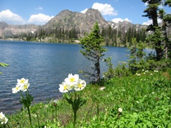 |
|||
| Trail Location: | Slavonia Trailhead | ||||
| Roundtrip Length: | 10.5 Miles | ||||
| Trailhead Elevation: | 8400 Feet | ||||
| Total Elevation Gain: | 2400 Feet | ||||
| Avg. Elev Gain / Mile: | 457 Feet | ||||
| Highest Elevation: | 10,790 Feet | ||||
| Trail Difficulty Rating: | 15.30 (strenuous) | ||||
| Parking Lot Latitude | 40.7841 | ||||
| Parking Lot Longitude | -106.7214 | ||||
Trail Description:
The Gilpin Lake / Gold Creek Lake Loop (now referred to as the Zirkel Circle) begins from the Slavonia Trailhead in the Routt National Forest, located near the town of Clark, Colorado (roughly 30 minutes north of Steamboat Springs). Most of this hike travels within the Mount Zirkel Wilderness Area.
With passage of the Wilderness Act in 1964, Mt. Zirkel was among the first designated wilderness areas in the country. Today, the Mt. Zirkel Wilderness Area encompasses roughly 160,000 acres that straddle the Continental Divide along the Park Range, as well as the southern edge of the Sierra Madre Range. It also contains the headwaters for the Elk, Encampment, and North Platte Rivers, has more than 70 lakes, and has roughly 170 miles of hiking trails. There are 15 peaks in the wilderness that rise above 12,000 feet in elevation, with 12,180-foot Mount Zirkel being the highest. The wilderness and the peak are both named after Ferdinand Zirkel, a German geologist.
From the Slavonia Trailhead you'll begin your hike along the Gilpin Lake Trail (#1161). Less than a quarter-mile from the trailhead you'll arrive at the Gold Creek Lake Trail (#1150) junction, which represents the starting point for the loop portion of this hike. Although you can proceed in either direction, we continued in a counter-clockwise direction because the gain in altitude isn't quite as steep. So, at this junction, we turned right onto the Gold Creek Lake Trail.
 Throughout the early portions of your hike you'll immediately notice some of the devastation from the freak windstorm that struck the area in 1997. Known as the Routt Divide Blowdown, winds in excess of 120 miles per hour were recorded during the height of this early winter storm. The devastating force of the storm brought down more than four million trees within a swathe of land 5 miles wide and 30 miles long. The Routt Divide Blowdown is regarded as the largest blowdown ever recorded in the Rocky Mountains.
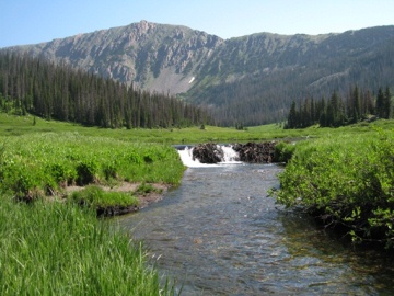
From the junction the trail mostly follows along Gold Creek as it proceeds up the valley. You should note that there are several stream crossings without the aid of a footbridge along this stretch, which may present problems for early season hikers wishing to keep their feet dry. As you proceed towards Gold Creek Lake you’ll also pass a picturesque 35-foot waterfall along the way.
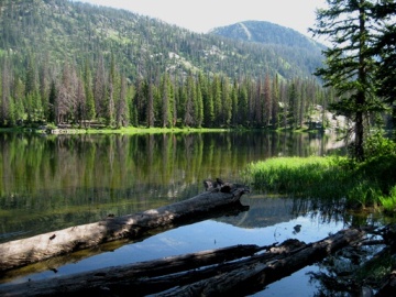
Roughly 3.2 miles from the trailhead hikers will reach Gold Creek Lake, an 8-acre body of water surrounded by fir and lodgepole pine. The trail skirts around the western and northern shore, while offering several different vantage points along this stretch. You may want to note that Gold Creek Lake is a very popular destination, so it's likely you won't be alone here.
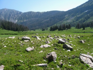
The next major destination on this loop is the broad meadow below Ute Pass. This incredibly beautiful, glacially carved valley is a great place to relax, or maybe do a little exploring. Actually, it would make for an outstanding destination in and of itself! As you look towards the east the prominent backdrop to the valley is Flattop Mountain, Ute Pass and the Continental Divide.
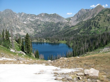
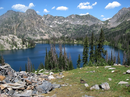
Just beyond the edge of the meadow, at roughly 4.5 miles, hikers will arrive at a fork in the trail. Here you'll turn left onto the Gilpin Lake Trail, which makes a relatively steep climb along rugged terrain to ascend Gilpin Ridge. At roughly 5.4 miles you'll reach the top of the ridge where you'll enjoy your first views of Gilpin Lake. The sight of this cobalt blue lake lying more than 450 feet below is stunning and dramatic – perhaps among the best in the Rockies. You'll also enjoy your first views of Big Agnes Mountain and Mt. Zirkel, which frame the lake above the opposite shore.
From the top of the ridge the trail descends rapidly towards the lake. Throughout this section, and just below the lake, hikers will enjoy a plethora of wildflowers during the early summer months.
Although the 29-acre lake looks like a blue sapphire from the top of the pass, it's actually crystal clear when viewed from the shoreline.
After navigating around Gilpin Lake the trail begins following Gilpin Creek for much of its way back to the trailhead. After passing a few more wildflower-filled meadows the path drops below treeline, and at roughly 9 miles you’ll reach the Mica Basin Trail junction. Beyond the junction the trail passes through a beautiful aspen grove before returning back to the Slavonia Trailhead.
Early season hikers should note that you could run into snow and ice in several areas along this route. You should check on conditions with the national forest prior to hiking this trail before the early-July time period.