Hallett Peak
| Trail Features: | Outstanding Panoramic Views, Glacier | 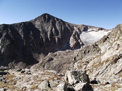 |
|||
| Trail Location: | Bear Lake | ||||
| Roundtrip Length: | 10.3 Miles | ||||
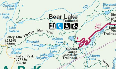
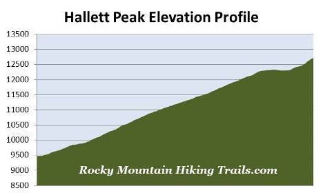
| Trailhead Elevation: | 9475 Feet | ||||
| Total Elevation Gain: | 3240 Feet | ||||
| Avg. Elev Gain / Mile: | 629 Feet | ||||
| Highest Elevation: | 12,713 Feet | ||||
| Trail Difficulty Rating: | 16.78 (strenuous) | ||||
| Parking Lot Latitude | 40.31196 | ||||
| Parking Lot Longitude | -105.64581 | ||||
Trail Description:
The hike to Hallett Peak in Rocky Mountain National Park begins from the Bear Lake Trailhead, located at the end of Bear Lake Road, nine miles from the turn-off at Highway 36. Due to the extreme popularity of the area you may want to consider using the free park shuttle to access the trailhead during the peak tourist season.
From the trailhead hikers will immediately make a right turn onto the Bear Lake Loop Trail. After a short walk along the eastern shore of Bear Lake you'll make another right turn onto the trail that leads towards Flattop Mountain. From here the trail passes through a pleasant aspen grove as it begins ascending the slopes of the Bierstadt Moraine.
Roughly one-half mile from the trailhead you'll reach the trail that leads to Bierstadt Lake and the Mill Creek Basin. Hikers should turn left at this junction to continue towards Hallett Peak. From here the route begins heading due west. As it climbs higher you'll enjoy spectacular views of Longs Peak, the Keyboard of the Winds, Pagoda Peak and Chiefs Head Peak as you look towards the south.
At just over one mile from the trailhead hikers will arrive at the Flattop Mountain Trail junction, which forks off to the left and begins ascending the eastern slopes of the mountain.
According to Rocky Mountain National Park: A History, the Arapaho and Ute Indians likely traveled across the park using east-west routes such as Trail Ridge, Forest Canyon, Fall River and Flattop Mountain in order to reach their traditional hunting grounds on the Great Plains. The Arapaho Indians called the Flattop Mountain corridor "The Big Trail". At one time the Flattop Mountain Trail was also known as the Grand Trail. A pathway was formally constructed in 1925, was rehabilitated by the Civilian Conservation Corps in 1940, and is now currently listed on the National Register of Historic Places.
Once on the Flattop Mountain Trail the grade steepens, and becomes moderately strenuous for much of the remaining route to the summit of Flattop Mountain. Roughly 1.7 miles from the trailhead, at an elevation of 10,480 feet, hikers will reach the Dream Lake Overlook where you'll enjoy magnificent views of Longs Peak. This is a great spot for an extended break.
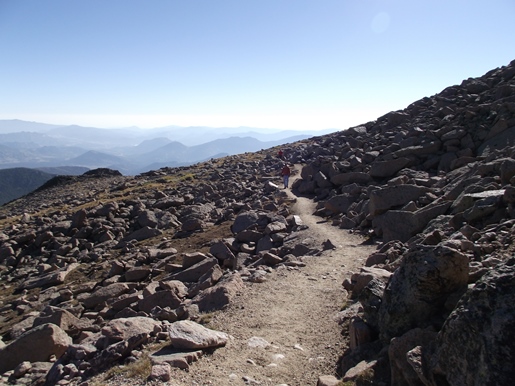
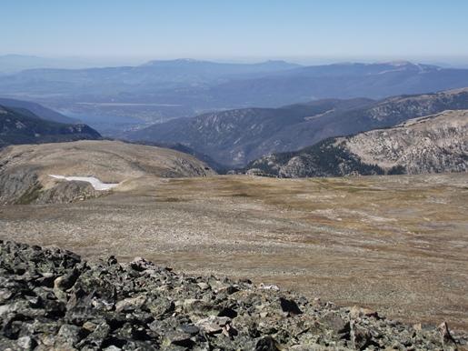
At 2.4 miles, and an elevation of roughly 11,000 feet, hikers will finally emerge above the treeline and enter the scrub pine / krummholz zone. At this point outstanding panoramic views will also begin to emerge, especially towards the east where you'll be able to see Bierstadt Lake, Sprague Lake and much of the Glacier Basin area.
At 3 miles you'll arrive at the Emerald Lake Overlook. Standing more than 1200 feet above the lake, this vantage point also offers stunning views. Off to your right, towards the southwest, is Hallett Peak. From this perch the trail begins to transition into the more barren and rocky terrain of the open tundra.
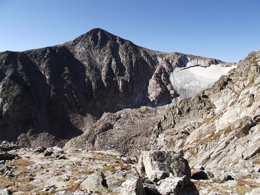
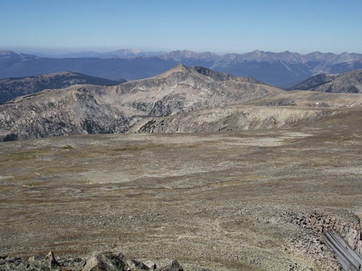
Just below the summit of Flattop Mountain, roughly 3.9 miles from the trailhead, hikers will reach a horse hitch rack where you'll enjoy great views of Hallett Peak and the Tyndall Glacier. From this point you'll have less than 200 feet of climbing along a mild grade to reach the top of the expansive plateau.
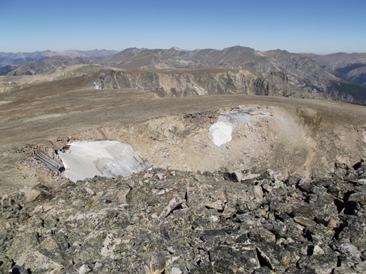
Shortly after reaching the top, at roughly 4.2 miles from the trailhead, look for an unmarked trail branching off towards the south (on your left). This is a great stopping point if you’re gassed, or bad weather is moving in. To continue towards Hallett Peak you should turn left at this junction and follow the unnamed path. This faint trail is quite rocky, and can be hard to follow in some places, but cairns will help guide the way. If in any doubt, simply head towards the peak. I highly recommend bringing trekking poles to help with balance along this rugged stretch.
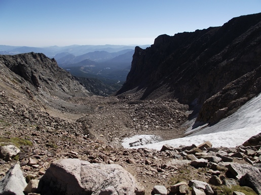
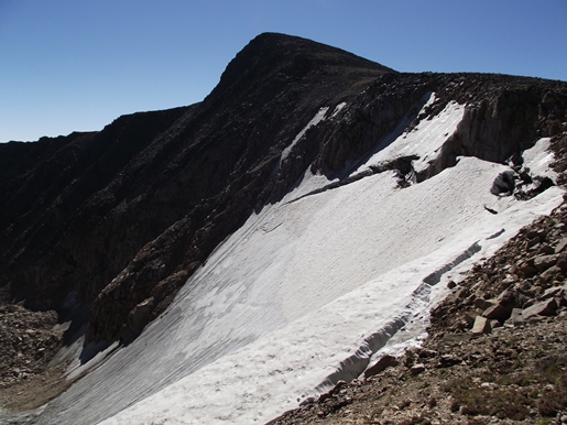
After walking about a quarter-of-a-mile the trail passes the Tyndall Glacier, which sits in the cirque between Flattop and Hallett Peak. The views down the Tyndall Gorge are pretty amazing. Hopefully it goes without saying, but it would be an extremely bad idea to step foot anywhere near the glacier.
Once past the glacier the trail begins to climb again, and becomes progressively steeper. As you climb higher the trail also becomes more difficult to read. There are cairns in many places, and sometimes the trail is pretty obvious, but route finding can still be fairly difficult. However, it's obvious where you're headed, so if in any doubt simply take the most obvious line to the top. On the way back down the trail is actually much easier to follow.
At just under 5.2 miles hikers will finally reach the summit of 12,718-foot Hallett Peak. As you might expect the views in all directions are spectacular, thus making this one of the best hikes in Rocky Mountain National Park. Towards the south is 12,486-foot Otis Peak and 13,153-foot Taylor Peak. Turn southeast and 14,259-foot Longs Peak will dominate the view. Looking towards the north is Flattop Mountain, 12,129-foot Notchtop Mountain, and the Mummy Range. 12,363-foot Ptarmigan Point and the Never Summer Range are located towards the northwest, and looking towards the southwest you'll be able to see Grand Lake and Shadow Mountain Lake in the valley below.
Hallett Peak is named for William Hallett, a prominent cattle rancher and mining engineer who climbed many of the peaks in this area in the late 1800s. Hallett was also instrumental in helping to establish the Rocky Mountain Club in 1896, the first mountaineering organization in Colorado.
The Arapaho Indians called Hallett Peak "banah ah netaieux," which means Thunder Peak, a reference to the storms that frequent the mountain. If it looks like bad weather is moving in during your hike, don't attempt to summit the mountain, as it will take at least an hour or two to get out of any immediate danger the storm could bring.
Hikers should always be aware of lightning risk while hiking in the Rocky Mountains, especially at higher elevations. As a general rule of thumb you should plan to be off the summit before noon in order to avoid the notorious afternoon thunderstorms that frequent the mountains during the summer months. Hikers should also be prepared for extreme sun exposure, wind, cool temperatures, and rapidly changing weather conditions while on the trail. Make sure you have the proper gear with you, and know what safety precautions you need to consider before venturing into the wilderness.