Hollowell Park Loop
| Trail Features: | Scenic Views, Lake Views, Solitude | 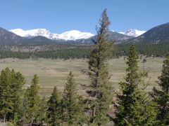 |
|||
| Trail Location: | Hollowell Park Trailhead | ||||
| Roundtrip Length: | 10.2 Miles | ||||
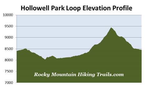
| Trailhead Elevation: | 8339 Feet | ||||
| Total Elevation Gain: | 1630 Feet | ||||
| Avg. Elev Gain / Mile: | 320 Feet | ||||
| Highest Elevation: | 9440 Feet | ||||
| Trail Difficulty Rating: | 13.46 (strenuous) | ||||
| Parking Lot Latitude | 40.34156 | ||||
| Parking Lot Longitude | -105.60530 | ||||
Trail Description:
The Hollowell Park Loop hike in Rocky Mountain National Park begins from the Hollowell Park Trailhead, located off Bear Lake Road just south of the Moraine Park area. From Highway 36, drive roughly 3.5 miles along Bear Lake Road to the turnoff for Hollowell Park Road, which will be on your right. The trailhead is located at the end of this short road.
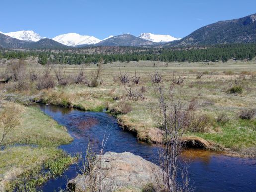
The first segment of the hike traverses across the sagebrush flats of Hollowell Park. After walking just one-third of a mile hikers will reach the loop portion of the hike. Although you can travel in either direction, we turned right to proceed in a counter-clockwise direction. From this junction the trail swings back towards the east and travels along the ridge above the parking lot. After walking roughly one-half mile along this trail, known as the Tuxedo-Hollowell Park Trail, you’ll begin walking above and parallel to Bear Lake Road. Over the course of the next mile this section of trail travels along a narrow footpath across sagebrush meadows and montane forests. During tick season (early spring through mid-summer) it's a good idea to periodically check yourself for ticks as you travel along this stretch.
At roughly 2.1 miles the trail dead-ends at a bridal path. You should turn left onto this path and begin ascending. After ascending this low hill, away from the road, hikers will begin traversing through a very beautiful ponderosa pine forest. After roughly four-tenths of a mile the bridal path reaches the South Lateral Moraine Trail. You should turn left at this junction to continue on the loop.
The South Lateral Moraine Trail traverses above Moraine Park, and offers periodic views through the trees of Moraine Park and the mountains towards the north. The trail eventually begins descending towards the valley, and at 3.2 miles will reach a park service road. To continue on the South Lateral Moraine Trail you should turn left here. From the junction the trail skirts around the southern edges of Moraine Park where you'll enjoy outstanding views of oxbows, wetlands and meadows, as well as the mountains towards the north. As you travel along this stretch you'll come across two splits in the trail. Although both splits converge further up the trail, your best bet is to stay to the right at each of them, which will allow you to travel over easier terrain.
At roughly 4.4 miles the trail crosses over Cub Creek. During the spring run-off, or after heavy rain, you may not be able to cross here without getting your boots wet. During such times you’ll have the option of traveling a very short distance up the hill where you should be able to find a viable place to cross over without getting wet. Just beyond the crossing hikers will arrive at the Cub Lake Trail junction. You should turn left here and continue towards the lake.
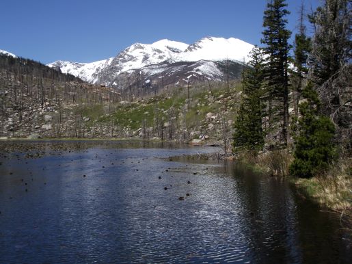
At roughly 6.3 miles hikers will reach Cub Lake. Unfortunately, as a result of all the dead trees that now completely surround it, Cub Lake is no longer the scenic spot it once was. The entire area surrounding the lake has been devastated by both the Fern Lake Fire of 2012, and the East Troublesome Fire of 2020. However, if you can make it down to the shoreline, there’s still a nice view of 12,922-foot Stones Peak towards the west.
From Cub Lake you should continue along the main trail until reaching the Mill Creek Trail junction, which is located a short distance beyond the head of the lake. Hikers should turn left here to continue on the loop. The Mill Creek Trail immediately begins to ascend the ridge above the western and southern banks of Cub Lake, and effectively does a semi-circle around the lake. This ascent is fairly strenuous, climbing roughly 820 feet in just over a mile to reach the summit. Along the way you’ll enjoy fantastic views of the lake, as well as Moraine Park in the far off distance, and Eagle Cliff Mountain at the far end of Moraine Park.
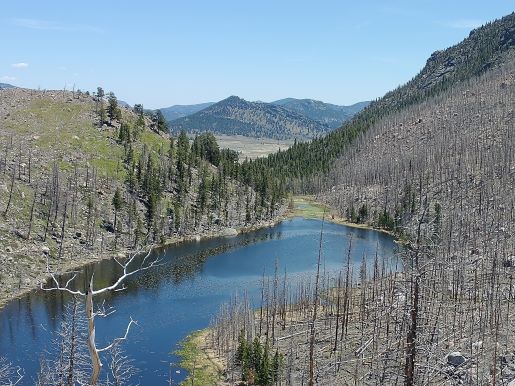
At 7.6 miles hikers will reach the top of the ridge separating the Cub Lake valley from the Mill Creek valley. From the top you’ll enjoy decent views of the surrounding mountains, mostly courtesy of the more recent East Troublesome Fire. Strangely, the wildfire has created a very interesting landscape at the top and south side of this ridge. You could almost describe it as being haunting, or even apocalyptic, devoid of any life (at least at the time of this writing). While the trail leading up the ridge from Cub Lake is quite rugged and steep, the opposite side is more of a gentle grade that traverses along much easier terrain.
As you proceed down towards Mill Creek you'll enjoy great views of Longs Peak and the mountains along the Continental Divide.
At roughly 8.25 miles, at the bottom of this ridge, hikers will reach the Mill Creek Basin. You’ll immediately reach a split in the trail here. Either route will take you back to Hollowell Park. We decided to take the right fork, which travels through a beautiful grassy meadow alongside Mill Creek. Shortly after the trail splits hikers will cross over a couple of creeks and pass by the Mill Creek Basin backcountry campsite before reaching another trail junction. You should turn left here to continue towards Hollowell Park.
At just over 9 miles hikers will reach the junction with the aforementioned trail that branched-off near the bottom of the ridge. You should turn right at this junction to continue towards Hollowell Park. From here the trail follows Mill Creek almost all the way back down to Hollowell Park.
At just over 9.8 miles hikers will return to Hollowell Park Trail. Simply turn right here to return back to the trailhead.