
Ice Lakes
| Trail Features: | Outstanding Views, Lakes, Wildflowers | 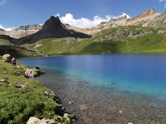 |
|||
| Trail Location: | South Mineral Campground (near Silverton) | ||||
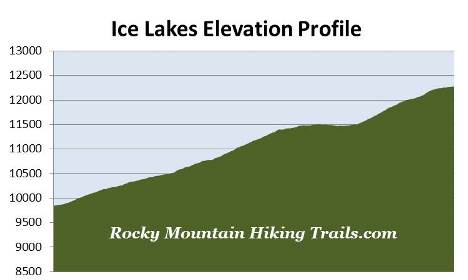
| Roundtrip Length: | 7.4 Miles | ||||
| Trailhead Elevation: | 9845 Feet | ||||
| Total Elevation Gain: | 2430 Feet | ||||
| Avg. Elev Gain / Mile: | 657 Feet | ||||
| Highest Elevation: | 12,274 Feet | ||||
| Trail Difficulty Rating: | 12.26 (strenuous) | ||||
| Parking Lot Latitude | 37.80672 | ||||
| Parking Lot Longitude | -107.77396 | ||||
Trail Description:
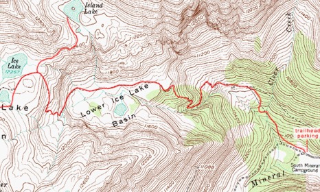
The hike to Ice Lakes begins from the South Mineral Campground in the San Juan National Forest near Silverton, Colorado. To reach the trailhead from the intersection of Highway 550 and the turnoff to Silverton (Highway 110), drive 2 miles north on Highway 550 to County Road 7, located between mile markers 72 and 73. Turn left onto County Road 7 (signed for the South Mineral Campground) and follow the gravel road for 4.4 miles to the trailhead parking area on the right side of the road, just across from the South Mineral Campground. This road is suitable for two-wheel drive vehicles, though there are a few potholes you'll have to contend with.
Hikers should note that parking for Ice Lakes is very limited, so you should plan to arrive early to secure a spot. If no parking spaces are available the national forest asks that you not park in the meadows, along the road, nor in the campground across the road. Instead, they ask that you wait for a spot to open, or choose to hike another trail in the Silverton Area, such as Highland Mary Lakes or Columbine Lake. Hikers should note that citations have been issued for illegal parking, which can be quite expensive. You should also note that the restroom near the parking lot is for paying campground guests only.
Ice Lake presumably receives its name as a result of it freezing over during the winter; however, it could just as well be from the ice-blue color of the water itself when the sun shines on it. I've never seen a lake with this brilliant of blue color before – it's quite amazing to see in person. Combine this with outstanding mountain scenery and several thousand wildflowers and you have one of the best hikes found just about anywhere.
The hike begins at the head of the South Mineral Valley where you'll enjoy brief views of the mountains towards the west. Almost immediately, however, the trail enters the canopy of a thick conifer forest, and soon begins ascending a series of short switchbacks along a moderate grade.
After walking roughly four-tenths of a mile the trail begins passing through a series of small wildflower-filled meadows, and at roughly one-half mile you'll cross over Clear Creek on a rickety log footbridge. If you look upstream from the bridge you'll see a nice waterfall flowing off the ledge above.
At just over nine-tenths of a mile hikers will reach a short spur trail, on the right, that leads to a close-up view of that same waterfall. Roughly a quarter-of-a-mile past the waterfall you'll reach another short side trail, on your left, which leads to the remnants of an old mining operation.
Shortly after passing the mine the terrain steepens, and the trail begins a sharp ascent towards the Lower Ice Lake Basin. Soon the trail emerges from the cover of the forest. From this point forward you'll be exposed to the sun, wind and the possibility of afternoon thunderstorms.
At roughly 2.2 miles, and an elevation of 11,400 feet, hikers will reach Lower Ice Lake Basin. Over the course of the next two-thirds of a mile or so the route travels over relatively flat terrain. After the winter snowpack melts the meadows in this basin bloom with a riot of wildflowers, and include varieties such as blue columbines, larkspur, chiming bells and aspen daisies. At just under 2.5 miles from the trailhead hikers will pass Lower Ice Lake nestled among the trees some three hundred yards off to your left.
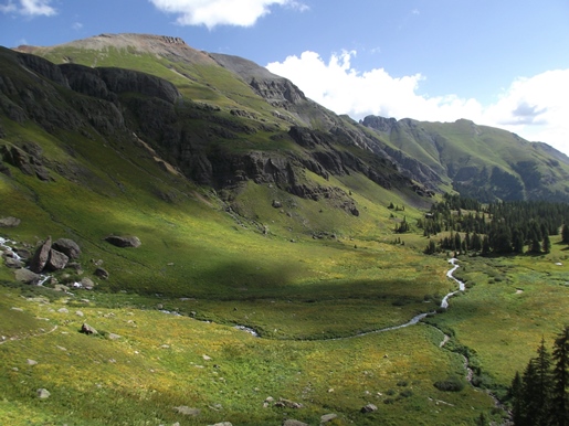
As you proceed deeper into the basin the landscape becomes progressively more scenic. Even during our late-August hike there were still quite a few wildflowers left. You'll also notice a couple of waterfalls streaming down the cliffs of the surrounding mountains.
At 2.9 miles hikers will cross a stream without the aid of a footbridge. Although we didn't have any problems during our hike, you might get your feet wet when water levels are higher. One of the interesting aspects about this small brook is that the rocks in the streambed are all chalk-white. We speculated that it might be the result of limestone leaching out from inside the mountain.
Just after crossing the stream the trail begins climbing steeply again, while gaining more than 660 feet over the next six-tenths of a mile or so. As you ascend along this stretch the views of the lower basin and the surrounding mountains are simply amazing.
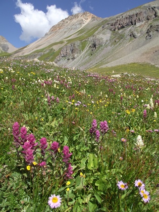
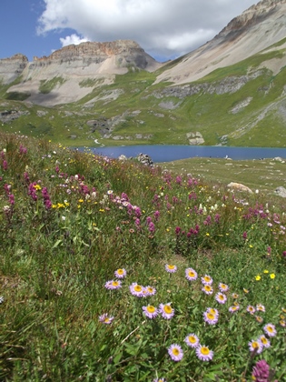
At roughly 3.5 miles hikers will finally reach the upper basin. A little further up the trail, at roughly 3.65 miles, you'll arrive at the faint side trail that leads to Ice Lake. During our late-August hike the alpine wildflowers in the upper basin were out of this world. We’ve never seen so many wildflowers in one place. There were literally thousands of them as far as the eye could see. During the short growing season you may see a wide range of varieties, including alpine forget-me-nots, moss campion, sky pilot, fairy primrose, purple fringe, columbine, chiming bells, neon pink paint brush and spring beauties. The typical bloom season for this area is from late July through August.
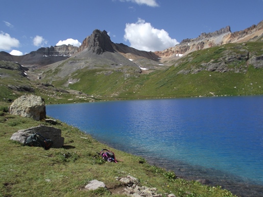
Just beyond the junction hikers will reach the eastern shore of Ice Lake. When the sun shined on the water it was the most intense cobalt blue I've ever seen in nature. The overall scenery here was absolutely stunning, and might be one of the best hikes I've ever taken. No wonder this is such an extremely popular hike! This extraordinary alpine lake is surrounded by several 13ers, including 13,761-foot Fuller Peak, 13,894-foot Vermillion Peak, 13,780-foot Golden Horn, 13,738-foot Pilot Knob and 13,767-foot U.S. Grant Peak, looking from left to right.
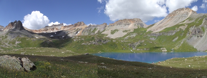
If you have the time and energy you'll have the option of exploring more of the upper basin area before returning to the trailhead. Look for side trails that lead to Island Lake, located northeast of Ice Lake, and Fuller Lake, located south of Ice Lake.
Hikers should always be aware of lightning risk while hiking in the Rocky Mountains, especially at the higher elevations. As a general rule of thumb you should plan to be off the highest point on your hike before noon in order to avoid the notorious afternoon thunderstorms that frequent the mountains during the summer months. Hikers should also be prepared for extreme sun exposure, high winds, cool temperatures, and rapidly changing weather conditions while on the trail. Make sure you have the proper gear with you, and know what safety precautions you need to consider beforehand.