Judd Falls
| Trail Features: | Waterfalls, Scenic Views, Fall Aspens | 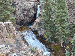 |
|||
| Trail Location: | Copper Creek Trailhead | ||||
| Roundtrip Length: | 2.3 Miles | ||||
| Trailhead Elevation: | 9590 Feet | ||||
| Total Elevation Gain: | 450 Feet | ||||
| Avg. Elev Gain / Mile: | 391 Feet | ||||
| Highest Elevation: | 9890 Feet | ||||
| Trail Difficulty Rating: | 3.20 (easy) | ||||
| Parking Lot Latitude | 38.96609 | ||||
| Parking Lot Longitude | -106.99384 | ||||
Trail Description:
The hike to Judd Falls in the Gunnison National Forest begins from the Copper Creek Trailhead, located roughly 4 miles north of Mount Crested Butte. To reach the trailhead from Crested Butte, head north on 6th Street. Continue along the main road through Mt. Crested Butte, while following signs to the Gothic Town site. On the north side of Mount Crested Butte the road turns into a dirt road, and becomes known as Gothic Road (and sometimes Schofield Pass Road). Roughly 7.5 miles from Crested Butte you’ll reach the Gothic Town site where the Rocky Mountain Biological Laboratory is located. A short distance later, at 8.3 miles from Crested Butte, you’ll reach the 2WD-vehicle parking area. This parking area is located on the left side of the road, with room for at least 15 vehicles. The road up to this point is in fairly good condition, and is easily passable for 2-wheel drive vehicles. However, you should still expect some washboarding and potholes in some areas.
The hike begins by ascending the jeep road opposite the parking area. For those that have high-clearance, 4-wheel drive vehicles you can proceed up this road for approximately a half mile and park near the official trailhead.
After ascending this rough and rugged jeep road, hikers will reach the Copper Creek Trailhead, located roughly one-half mile above Gothic Road. Hikers should continue along the Copper Creek Trail by passing through the gate here. The trail continues as a rough road beyond the gate.
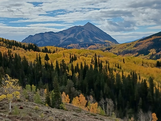
At roughly seven-tenths of a mile the trail tops out and you’ll immediately see a sign that reads welcome to the Judd Falls Trail. Looking almost straight ahead during this stretch, 12,153-foot Crested Butte will dominate the view towards the southeast.
As you proceed down the road you’ll pass one of the Rocky Mountain Biological Laboratory's weather stations. The data collected from these stations is used to see how climate impacts plants and animals over the long term. Just beyond this point you’ll see a sign pointing the way towards the Judd Falls overlook. You’ll also pass a private road along this stretch. You should continue straight ahead (left) at this junction. At this point you’ll begin walking along a single track footpath.
At just over a mile the trail begins a fairly steep descent for a brief stretch. Along this section you’ll pass an unmarked side trail leading up from the Rocky Mountain Biological Laboratory. You should stay to the left at this junction to continue to the falls.
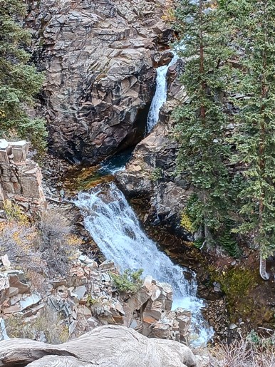
At just over 1.1 miles you’ll reach the Judd Falls overlook. The best vantage point is located a few yards to the right where you’ll find a wooden bench overlooking the two-tiered falls. The falls are named for Garwood Hall Judd, who lived in this area after the silver rush played out in the 1880s. He eventually became known as “the man who stayed.”
This is obviously a fairly short hike, so if you have the time and energy you can continue along the Copper Creek Trail where you’ll enjoy nice views of the surrounding mountains. During the fall, the aspens could headline the show.
Additional Resources:
* Grand Mesa, Uncompahgre and Gunnison (GMUG) National Forests
* Trails Illustrated Map for Crested Butte area