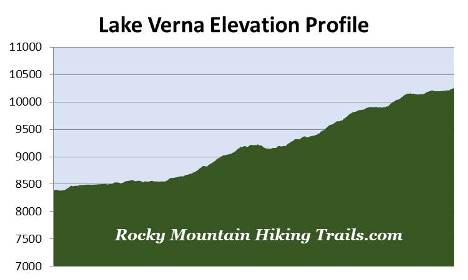
Lake Verna
| Trail Features: | Scenic Lake Views, Waterfalls, Wildlife | 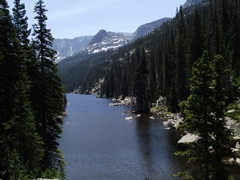 |
|||
| Trail Location: | East Inlet Trailhead | ||||
| Roundtrip Length: | 13.8 Miles | ||||
| Trailhead Elevation: | 8390 Feet | ||||
| Total Elevation Gain: | 1975 Feet | ||||
| Avg. Elev Gain / Mile: | 286 Feet | ||||
| Highest Elevation: | 10,255 Feet | ||||
| Trail Difficulty Rating: | 17.75 (strenuous) | ||||
| Parking Lot Latitude | 40.2398 | ||||
| Parking Lot Longitude | -105.80001 | ||||
Trail Description:
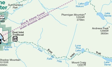
The hike to Lake Verna begins from the East Inlet Trailhead near the town of Grand Lake on the west side of Rocky Mountain National Park. After turning into the Grand Lake area from Hwy 34 / Trail Ridge Road, drive three-tenths of a mile on West Portal Road until you reach a split in the road. Stay left at this junction and continue on West Portal Road for another 2 miles to reach the trailhead.
From the parking area the trail proceeds through a mixed forest of pine and aspens. After walking roughly one-third of a mile you'll reach the Adams Falls Trail, a semi-loop that reconnects with the East Inlet Trail in less than two-tenths of a mile. To visit the falls, turn right at this junction and walk the short distance to an overlook of Adams Falls, which drops roughly 55 feet in a series of steps through a narrow rock gorge.
 From the overlook the trail climbs to the top of the falls where you'll have another outstanding view from above. Looking off into the distance you'll also be able to see Grand Lake from this vantage point.
Although you may assume that the falls were named after Alva Adams, the former Colorado Senator for whom the nearby Alva B. Adams Tunnel is named after, the falls, as well as nearby Mt. Adams, are actually named for Jay E. Adams, an early settler who arrived in the Grand Lake area in the late 1800s. Prior to receiving its current name the waterfall was known as Ousel Falls.
From the top of the falls the semi-loop portion of the hike continues for a very short distance before linking up with the East Inlet Trail once again. To continue towards Lake Verna you should turn right here.
The East Inlet Trail is an excellent example of National Park Service naturalistic design work. Both the National Park Service and the Civilian Conservation Corps built naturalistic designed trails that required the use of local materials, such as rock, wood and dirt, in order to harmonize with the local environment. It also required a maximum grade of 15%, a width of 3-4 feet, and has to meet sustainability standards through the use of stone steps, log checks, and log or stone culverts. As a result, the East Inlet Trail was listed on the National Register of Historic Places in 2005.
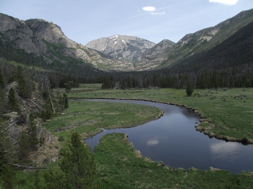
At roughly six-tenths of a mile hikers will reach the outskirts of East Meadow. Here you'll enjoy outstanding views of East Inlet Creek as it snakes through the valley under the gaze of Mount Cairns, Mount Craig and Mount Wescott. From here the trail circles around to skirt along the northern edge of this immense meadow.
At roughly 1.3 miles hikers will pass the East Meadow Backcountry Campground, and at roughly 1.4 miles you'll reach a low bluff that offers commanding views of East Meadow and East Inlet Creek. This rock outcropping is also a great place to spot a variety of wildlife in the grassy meadows below, including moose, elk and deer.
From the outcropping the trail continues to travel along the northern edge of the meadow. At roughly 2.4 miles you'll pass the Lower East Inlet Backcountry Campground. Once past the meadow the trail begins to climb the lower slopes of Mt. Cairns. As it ascends the rocky and rugged terrain you'll begin to enjoy some great views towards the west where you'll be able to see Grand Lake in the far-off distance. From these heights you'll also notice the thousands of dead and dying lodgepole pine trees throughout the broad valley, a result of the pine beetle infestation.
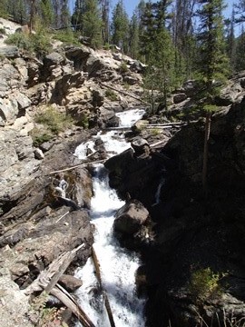
At just over 3.8 miles hikers will pass the Cats Lair Backcountry Campground, and at roughly 5.1 miles you'll pass the Gray Jay Backcountry Campground. Throughout this portion of the hike you'll also pass several waterfalls and cascades along the way.
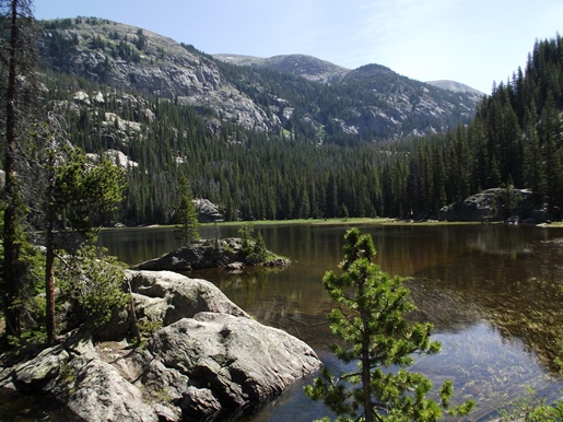
At roughly 5.5 miles hikers will reach Lone Pine Lake. There's a large granite rock slab near the southwestern end of the lake that provides a nice viewing area, and a great place to sit and soak in the great views. From this low perch Peak 12,260 and Andrews Peak will dominate the view above the opposite shore. The name for this lake purportedly comes from a park ranger who visited the lake in the 1930s and noticed a lone pine growing atop the small granite rock island near the southwestern corner of the lake. Today there are three or four trees growing on the island.
 From the lake the trail begins to climb again. As it gains the top of the saddle you'll have a nice view of Lone Pine Lake resting roughly 200 feet below. Along this stretch you'll pass the Slick Rock Backcountry Campground at roughly 6 miles, and the Solitaire Backcountry Campground at roughly 6.2 miles. Almost a half mile beyond Solitaire there will be a small unnamed lake. Just beyond this lake is the Upper East Inlet Backcountry Campground.
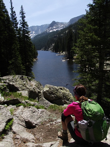
At 6.9 miles hikers will finally reach a rock outcropping that stands high above the northwestern shore of Lake Verna. This perch offers great views of the narrow lake and the rugged mountains rising above the opposite shore. This beautiful subalpine lake is roughly 30 acres in size, and is the largest lake in the East Inlet valley.
From this perch the trail continues around the northern shore of Lake Verna, and will provide more expansive views from the northeastern corner of the lake. Beyond Lake Verna there is an unimproved, and in some cases hard-to-follow route that continues up to Spirit Lake and two other alpine lakes further up the rugged canyon. Apparently the national park ran out of names, and opted to simply call these two lakes "Fourth Lake" and "Fifth Lake".