Little Horseshoe Park Loop
| Trail Features: | Panoramic Views, Wildlife, Wildflowers | 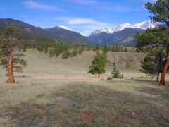 |
|||
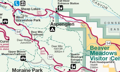
| Trail Location: | Deer Ridge Junction | ||||
| Roundtrip Length: | 3.9 Miles | ||||
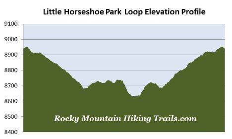
| Trailhead Elevation: | 8940 Feet | ||||
| Total Elevation Gain: | 472 Feet | ||||
| Avg. Elev Gain / Mile: | 242 Feet | ||||
| Highest Elevation: | 8952 Feet | ||||
| Trail Difficulty Rating: | 4.84 (easy) | ||||
| Parking Lot Latitude | 40.3870 | ||||
| Parking Lot Longitude | -105.60980 | ||||
Trail Description:
The Little Horseshoe Park Loop hike in Rocky Mountain National Park begins from Deer Ridge Junction, located roughly 3 miles west of the Beaver Meadows Entrance where highways 34 and 36 intersect. Nearby Deer Mountain is one of the more popular destinations in the park. As a result, due to limited parking along the roadside, it's usually best to arrive early in order to avoid the crowds.
Although you would never know it now, Deer Ridge Junction was once the site of the Deer Ridge Chalet. During its lifespan, between 1917 and 1960, the thriving tourist business included a lodge, cabins, restaurant, filling station, a 50-foot observation tower, and a ski run that ran down into Little Horseshoe Park. Rocky Mountain National Park acquired the property in 1960, and proceeded to dismantle and remove the structures over the course of the following year.
The "lollipop" route begins in a stand of mature ponderosa pine as it initially heads in an easterly direction. At roughly one-tenth of a mile you’ll reach the Deer Mountain Trail, which branches off to the right. Hikers should proceed to the left here to continue towards Little Horseshoe Park.
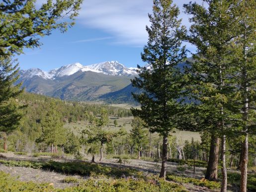
Just beyond the split hikers will begin enjoying outstanding views of 12,454-foot Mt. Chapin, 13,069-foot Mt. Chiquita, 13,514-foot Ypsilon Mountain and 13,502-foot Fairchild Mountain towards the northwest. From here the trail also begins to meander down the western slopes of Deer Mountain along a gentle grade as it makes its way towards the valley.
Roughly one mile from the trailhead hikers will arrive at the first in a series of trail junctions. You should proceed to the left here to continue towards Little Horseshoe Park. Although none of the trails along this route have specific names, the route is well marked by trail signs at every junction.
From the first junction the trail begins to pass along the edge of a large grassy meadow known as Little Horseshoe Park. This broad valley provides hikers with a chance to spot a variety of wildlife, including elk, mule deer and Wyoming ground squirrels; as well as a wide variety of birds, such as turkey, woodpeckers, mountain bluebirds, hummingbirds and swallows. During the late spring and early summer look for a wide variety of wildflowers throughout this stretch as well.
At roughly 1.2 miles you'll arrive at the second junction. You should proceed to the left here. At roughly 1.4 miles hikers will finally reach the loop portion of the hike. This junction is marked by a trail sign that reads, “Loop Trail Shortcut”. Since this description follows the short loop in a clockwise direction, you should proceed towards the left here as well. Hikers should note that this portion of the hike sees a fair amount of horse traffic, mostly coming from the Aspenglen Campground area.
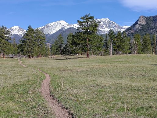
At roughly 1.7 miles hikers will pass near an old park building, and at just over 1.8 miles you'll reach a dirt service road. To continue on the loop you should turn right here. The loop trail branches off the dirt road after walking roughly 25 yards. After turning right onto the loop and walking another 25 yards or so, the trail reaches another junction. To stay on the loop you should turn right here as well. During this section of the hike you'll pass through a broad meadow that offers sweeping views of the Mummy Range, including Mt. Chapin, Mt. Chiquita and Ypsilon Mountain.
At roughly 2.25 miles hikers will reach the lower shortcut trail junction. You should proceed to the right here to continue on the loop. The trail to the left leads to the Aspenglen Campground.
At just over 2.5 miles hikers will complete the loop portion of this hike. Simply retrace your steps back to trailhead by turning right at the next two junctions.