Mesa Creek Trail
| Trail Features: | Scenic Views | 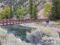 |
|||
| Trail Location: | Curecanti National Recreation Area | ||||
| Roundtrip Length: | 1.5 Miles | ||||
| Trailhead Elevation: | 6555 Feet | ||||
| Total Elevation Gain: | 275 Feet | ||||
| Avg. Elev Gain / Mile: | 367 Feet | ||||
| Highest Elevation: | 6555 Feet | ||||
| Trail Difficulty Rating: | 2.05 (easy) | ||||
| Parking Lot Latitude | 38.45219 | ||||
| Parking Lot Longitude | -107.54444 | ||||
Trail Description:
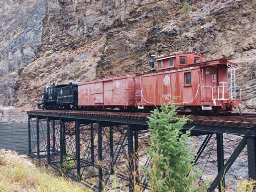
The hike along Mesa Creek Trail begins near the confluence of the Gunnison River and the Cimarron River in the Curecanti National Recreation Area. The turnoff for the trailhead is located roughly 20 miles east of Montrose and 45 miles west of Gunnison on Highway 50. Look for the turnoff between mile markers 112 and 113, near where the road crosses over the Cimarron River. From Highway 50 drive one mile to the end of the paved road near the foot of the Morrow Point Dam. Just before reaching the parking area you’ll pass the Cimarron Canyon Rail Exhibit. Engine 278, presented here, was built in 1882, and remained in use for over 70 years. The engine and its cars now rest on a steel deck span bridge that was originally constructed in 1895.
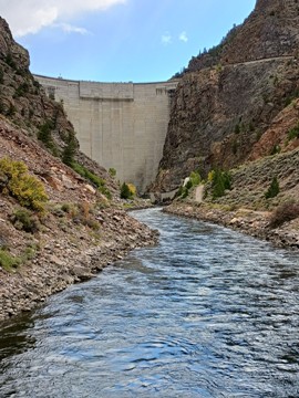
The hike begins by descending along the rugged canyon above the Cimarron River. After a relatively short distance, you’ll reach an unmarked junction. To the right you can walk up to the foot of the Morrow Point Dam, a 468-foot-tall concrete double-arch dam on the Gunnison River, which creates the 817-acre Morrow Point Reservoir. To continue along the Mesa Creek Trail you should turn left here and proceed across the river. Before crossing the bridge, note the warning posted by the park with regards to sudden dam releases!
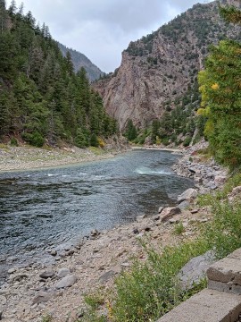
Once on the other side the trail begins traveling downstream along the north side of the Gunnison River. At just over one-third of a mile you’ll reach another unmarked split in the trail. You should stay to the left here to continue along the main trail.
At roughly three-quarters of a mile the trail abruptly ends at a point where the rock face of the canyon drops down into the river itself. At this point there’s no other place to go, but to turnaround.
Although a rather short hike, the canyon is quite scenic. This is a great warm-up hike, or a chance to stretch your legs while traveling along Highway 50.
Additional Resources:
* Curecanti National Recreation Area
* Trails Illustrated Map for the Black Canyon of the Gunnison National Park and Curecanti National Recreation Area