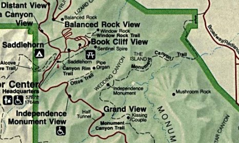
Lower Monument Canyon Trail
| Trail Features: | Outstanding Views | 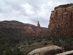 |
|||
| Trail Location: | Lower Monument Canyon TH (Hwy 340) | ||||
| Roundtrip Length: | 6.9 Miles | ||||
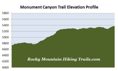
| Trailhead Elevation: | 4740 Feet | ||||
| Total Elevation Gain: | 815 Feet | ||||
| Avg. Elev Gain / Mile: | 236 Feet | ||||
| Highest Elevation: | 5375 Feet | ||||
| Trail Difficulty Rating: | 8.53 (moderate) | ||||
| Parking Lot Latitude | 39.1087 | ||||
| Parking Lot Longitude | -108.70153 | ||||
Trail Description:
"I came here last year and found these canyons, and they feel like the heart of the world to me. I'm going to stay and build trails and promote this place, because it should be a national park."
- John Otto - the first white man to explore what would become Colorado National Monument
Other than driving along Rim Rock Drive, hiking the Monument Canyon Trail is probably the most popular activity in Colorado National Monument. Hikers have a couple of options with regards to this iconic hike. You can do a one-way thru-hike of the entire 6-mile trail. This, however, requires two vehicles. You can also do a portion of the trail beginning from the trailhead on Rim Rock Drive, which would require a steep 600 descent into the canyon, and conversely, a 600-foot climb back to the top.
 A third option, which this hike
description follows, begins from the lower trailhead off Colorado State Highway 340. To reach this trailhead take Exit 19 off I-70 near Fruita and drive south to just beyond mile marker #5, roughly 2.1 miles past the junction to the road leading into Colorado National Monument. It may seem that you’re turning into a subdivision, but the trailhead parking area will soon appear.
A third option, which this hike
description follows, begins from the lower trailhead off Colorado State Highway 340. To reach this trailhead take Exit 19 off I-70 near Fruita and drive south to just beyond mile marker #5, roughly 2.1 miles past the junction to the road leading into Colorado National Monument. It may seem that you’re turning into a subdivision, but the trailhead parking area will soon appear.
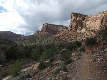
From the parking lot the trail travels southward. Roughly one-tenth of a mile from the trailhead you'll reach a side trail that leads into Wedding Canyon. In conjunction with the Monument Canyon Trail, this unimproved trail can be used to create a loop hike.
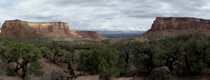
During the first seven-tenths of a mile the Monument Canyon Trail skirts around a subdivision. The barbed wire fence bordering the park may give you the illusion that you're walking around a penitentiary. At the end of the fenced-in area the trail makes a sharp turn towards the west, and finally enters into the lower portions of Monument Canyon. Soon you’ll leave the homes and the noise from Highway 340 behind. If you look straight up the canyon at this point you should be able to see Independence Monument in the far-off distance.
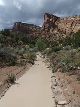
Before our most recent hike there were several days of heavy rain. It was still overcast that morning, and the air was quite humid, which I found to be somewhat strange for this part of the country. Normally, hikers should expect very dry and very hot conditions, with almost 100% exposure to the sun along the entire route. In fact, during the warmer months of the year, it's best to start your hike in the early morning.
As a result of the recent rain the normally dry wash at the bottom of the canyon was flowing with liquid mud, which looked more like chocolate ice cream on a hot sidewalk.
 As we passed further up the sandstone canyon the scent of juniper, sagebrush and pinyon pines wafted through the air.
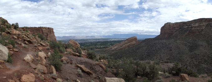
At just over a mile from the trailhead you'll have a nice view of the lower portion of the canyon, as well as Grand Valley in the far-off distance towards the east.
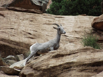
At roughly 1.4 miles we saw a herd of bighorn sheep on the ledges above us. There were probably eight or nine males, females and lambs staring down upon us as we made our way up the canyon. Just above them, no more than 25-50 feet away, I saw what appeared to be a grey fox running away from the herd. It's possible it may have been a coyote, but it appeared to be much smaller than a normal sized adult.
Some of the other wildlife you may encounter in the park includes mule deer, mountain lions, collared lizards, red-tailed hawks, golden eagles, turkey vultures, ravens and pinyon jays.
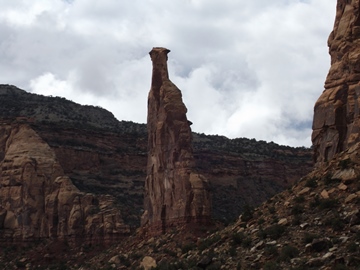
At 1.8 miles the trail rounds a corner and finally levels off after climbing roughly 500 feet from the trailhead. Here you'll have your first full view of Independence Monument. Standing 450 feet above the canyon floor, it's the highest free standing rock formation in the park.
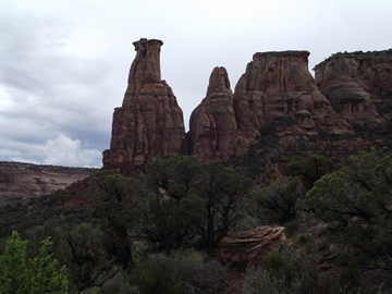
At roughly 2.4 miles hikers will finally reach the base of Independence Monument. Also located here is the junction with the Wedding Canyon Trail, which makes up part of the loop hike mentioned above. You'll also have some excellent views of the Kissing Couple rock formation towards the south.
Independence Monument received its name from John Otto, the first white man to begin exploring the canyon area in 1906. After pounding iron pipes and carving out footsteps into solid rock for several weeks, Otto became the first person to stand atop the monolith on June 8, 1911. On the Fourth of July of that same year, Otto placed the American flag at the top of Independence Monument, thus starting a tradition that continues to this day.
Although Otto was a bit of an eccentric, living alone in the canyon and carving out trails, he at least had the foresight to lay the foundation for protecting this beautiful area. He spearheaded many efforts to turn the canyon into a national park. Although it still hasn't quite received that status, the area was established as Colorado National Monument on May 24, 1911 as a result of his perseverance. Otto was subsequently hired as the first park ranger. For the next 16 years he continued building and maintaining trails while living in a tent in the park - and drawing a salary of $1 per month.
Otto tried to settle down. On June 20, 1911, at the base of Independence Monument, he married an artist by the name of Beatrice Farnham. Only a few weeks after the wedding, however, she left him and never returned. Sometime afterwards she was quoted as saying, "I tried hard to live his way, but I could not do it, I could not live with a man to whom even a cabin was an encumbrance."
It's not entirely clear as to whether Independence Monument received its name as a result of Otto placing a flag atop of it on the Fourth of July, or because his bride left him there….
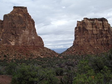
From the Monument the trail continues to the base of the Kissing Couple rock formation. As you make your way over towards the formation be sure to look back periodically at Independence Monument. You'll notice that the view of the rock is much different than the iconic photographs you normally see.
At 3.45 miles hikers will reach the base of the Kissing Couple. There are a few places around here to pull up a rock and soak in the scenery. Here you'll have a great view of the Grand Valley, as well as Mushroom Rock across the canyon. Rim Rock Drive is still another 2.5 miles further up trail from this point, if you wish to continue.
As we sat there eating our lunch we could hear a rock slide across the valley. Then, about a half-mile into our return trip, we heard what I thought was a herd of animals rushing towards us. After a split second I realized that what I was hearing was rock crashing down from the Rim Rock plateau area, and looked just in time to see a fairly large slide coming down the canyon wall.
If you only have a few hours to spend in the park, hiking the Monument Canyon Trail is probably the best way to see it.