Moraine Park Loop
| Trail Features: | Panoramic Views, Wildlife | 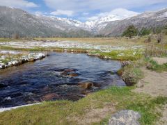 |
|||
| Trail Location: | Moraine Park Trailhead | ||||
| Roundtrip Length: | 4.8 Miles | ||||
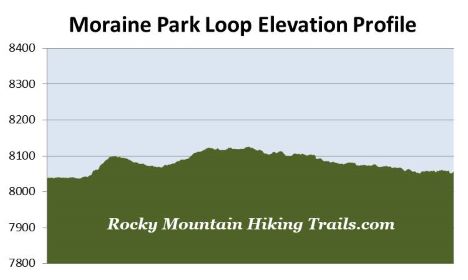
| Trailhead Elevation: | 8038 Feet | ||||
| Total Elevation Gain: | 120 Feet | ||||
| Avg. Elev Gain / Mile: | 50 Feet | ||||
| Highest Elevation: | 8128 Feet | ||||
| Trail Difficulty Rating: | 5.04 (moderate) | ||||
| Parking Lot Latitude | 40.35403 | ||||
| Parking Lot Longitude | -105.58396 | ||||
Trail Description:
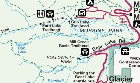
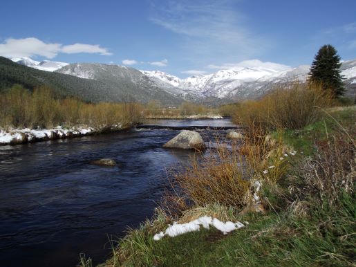
The Moraine Park Loop hike in Rocky Mountain National Park begins from the Moraine Park Trailhead, located on Bear Lake Road roughly 1.5 miles from the turn-off at Highway 36. The unmarked trailhead is located off the short side road, just before reaching the auto bridge that crosses over the Big Thompson River. There’s a fairly large parking lot located on your left just prior to reaching this bridge.
Near the auto bridge you’ll see a gate in the fencing along the north side (on the right) of the Big Thompson River. The hike begins by passing through this gate. You’ll pass through a second gate after walking a very short distance across the valley floor. This fencing was temporarily placed here by the park in order to help protect and restore key vegetation, such as aspen and willow, from an overpopulation of elk in this area. According to the park website this project will be reviewed every five years. Once a full recovery has been determined, and the elk population is brought back to more sustainable numbers, the fencing will be removed.
During this stretch hikers will travel over a narrow footpath that follows alongside the river. After passing through the two gates the trail converges with a wider path, and begins heading in a northwesterly direction. As you travel along this stretch, 12,274-foot Snowdrift Peak and 12,922-foot Stones Peak will tower above the valley floor towards the west, which will provide a dramatic backdrop to this incredibly beautiful glacially-carved landscape.
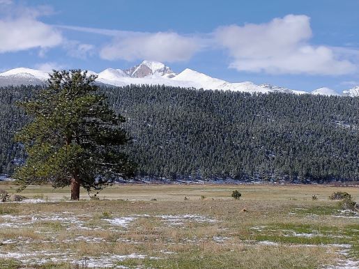
At roughly three-quarters of a mile hikers will reach a split in the trail. You should to stay to the left at this junction to continue on the loop. At this point you'll notice Longs Peak rising above the South Lateral Moraine towards the south. At just under nine-tenths of a mile you’ll reach Fern Lake Road. You should turn left onto this road. Over the next 1.1 miles this loop travels along the road until reaching the Cub Lake Trailhead. As a result, we highly recommend starting your hike early, and proceeding in a counter-clockwise direction in order to complete the road portion of this hike before heavy traffic begins arriving.
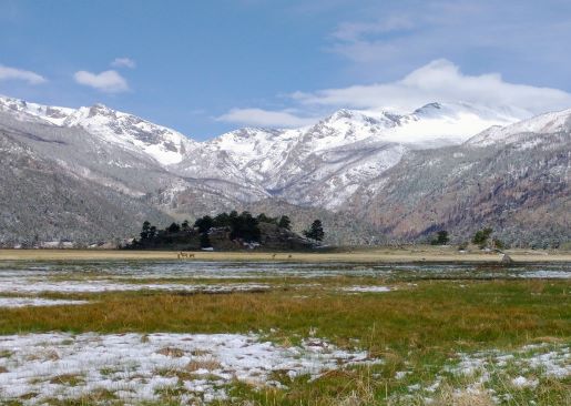
By this point there’s a pretty good chance you will have already seen elk on this hike. In fact, Moraine Park is one of the best places to see elk in Rocky Mountain National Park, especially during the fall, winter and spring months. During the fall Moraine Park is a great place to see the mating rituals of elk during the annual rut. During this time period your chances of coming too close to these animals is highly elevated, at a time when they are their most dangerous. As a result, the park implements closures for this area during this timeframe.
At just over 2 miles hikers will finally reach the Cub Lake Trailhead. You should turn left here to continue on the loop. After walking a very short distance hikers will cross over the Big Thompson River and begin traveling towards the south.
At roughly 2.6 miles hikers will reach the Cub Lake Trail junction. You should proceed to the left, onto the unmarked South Lateral Moraine Trail, to continue on the loop hike. Cub Lake is located roughly 1.9 miles from this junction, if you wish to add this excursion to your hike.
Just beyond the junction the trail crosses over Cub Creek. During the spring run-off, or after heavy rain, you may not be able to cross here without getting your boots wet. During such times you’ll have the option of traveling a very short distance up the hill where you should be able to find a viable place to cross over without getting wet. Just beyond the crossing you’ll reach another unmarked junction. Simply turn left here to continue on the loop.
From this junction the trail begins traveling along the southern edge of the great meadow. You’ll pass numerous oxbows and wetlands along this stretch. Keep an eye out for a variety of wildlife in this section. At roughly 3.25 miles you’ll reach an unmarked split in the trail. You should stay left here. After roughly one hundred yards the two trails merge again. Shortly thereafter will be another split, which will once again merge further down the trail. We stayed to the left at both junctions, which kept us near the edge of the meadow during this section.
At roughly 4 miles hikers will reach a park service road, which you’ll follow all the way back to the trailhead. This dirt road continues along the southern edge of Moraine Park, and eventually begins passing through park employee housing. The hike ends after crossing over the auto bridge mentioned above.