Mt. Elbert
| Trail Features: | Outstanding views | 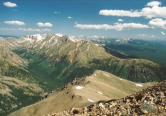 |
|||
| Trail Location: | North Elbert Trailhead | ||||
| Roundtrip Length: | 9.4 Miles | ||||
| Trailhead Elevation: | 10,040 Feet | ||||
| Total Elevation Gain: | 4700 Feet | ||||
| Avg. Elev Gain / Mile: | 1000 Feet | ||||
| Highest Elevation: | 14,440 Feet | ||||
| Trail Difficulty Rating: | 18.80 (strenuous) | ||||
| Parking Lot Latitude | 39.152096 | ||||
| Parking Lot Longitude | -106.412628 | ||||
Trail Description:
There are five routes that lead to the summit of Colorado's highest mountain. The standard route, via the Northeast Ridge, begins from the North Mount Elbert Trailhead, located just outside of Leadville. To reach the trailhead from U.S. 24, turn west onto Colorado 300 and cross over the railroad tracks. Drive roughly 0.7 miles, and then turn left onto Lake County Road 11 towards Halfmoon Creek. After driving 1.2 miles turn right towards the Halfmoon Creek Campground and drive another 5 miles along a dirt road (2WD with washboard and potholes) to the North Mt. Elbert Trailhead. The large parking area will be on the left side of the road.
The 14,440-foot mountain is named for Samuel Elbert, who served as a territorial governor of Colorado in 1873-1874, and as Colorado State Supreme Court Justice for another 12 years. As part of the Hayden Geological Survey, Henry W. Stuckle made the first documented ascent of Mt. Elbert in 1874. Since then the peak has been purportedly climbed by mule, horse, ATV, and even by jeep!
As crazy as it might sound now, there were several individuals in the 1930s and 40s who felt that 14,428-foot Mt. Massive, Elbert's neighbor to the north, was more deserving of being Colorado's highest mountain. The group apparently embarked on a campaign to stack rocks at the summit in order to raise the height of the mountain. Those that wanted to keep the status quo would periodically visit Mt. Massive and dismantle the over-sized cairn. At some point the pro-Massive group realized their quest was becoming quixotic, and eventually gave up.
 Although Mt. Elbert is the highest point in Colorado, and the second highest mountain in the lower 48, the hike via the Northeast Ridge is relatively easy, and relatively safe. One of the keys to a successful summit is to make sure that you're properly acclimated.
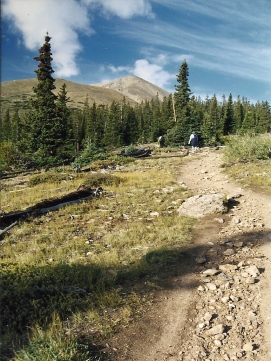
Shortly after leaving the trailhead hikers will arrive at the Colorado Trail junction. From here you'll turn left to follow the Colorado Trail for a little more than mile. After ascending several switchbacks, and passing the remnants of an old miner’s cabin, hikers will arrive at the North Mt. Elbert Trail junction, located roughly 1.3 miles from the trailhead. You should turn right at this fork to continue towards the summit. Shortly thereafter you'll begin ascending Mount Elbert's northeast ridge.
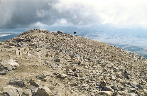
At roughly 3 miles from the trailhead, and an elevation of roughly 11,900 feet, hikers will reach the treeline. Although you'll have a great view of the peak, you won't be able to see the summit from this vantage point. In fact, as you climb higher, there are a couple of false summits that will lead you to believe that you're closer than you really are.
At roughly 13,400 feet the route becomes much steeper. This next section of trail gains almost 500 feet in roughly three-tenths of a mile as it climbs the rugged talus/scree ridge. Once above this section, however, the path to the summit becomes progressively easier.
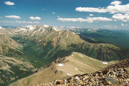
At roughly 4.7 miles hikers will finally reach the summit. From the top the views in every direction are simply spectacular. Mt. Massive, the second highest mountain in Colorado, dominates the views towards the north, while 14,336-foot La Plata Peak can be seen looking towards the south. From this perch you'll be standing at the highest point between Mt. Whitney in California, Fairweather Mountain in northern Canada, La Malinche Mountain in Mexico, and Mont Blanc in France.
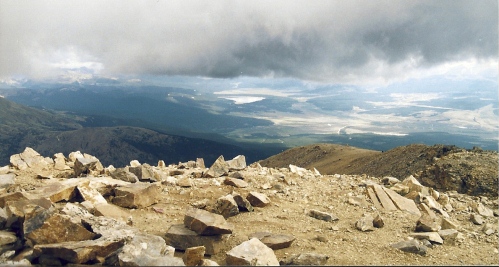
Our first hike up Mt. Elbert became a race against the weather as skies darkened the higher we climbed. After hearing thunder almost directly above us, we had just enough time to shoot a couple of photos from the summit. Shortly thereafter we began to get pelted by small-sized hail. Fortunately this lasted less than ten minutes, and we were able to safely descend. Since we didn't get a chance to enjoy the views that day we decided to hike the mountain again two years later. This time we had absolutely beautiful weather and were able to spend more than hour at the top.
Hikers should always be aware of lightning risk while hiking in the Rocky Mountains, especially at higher elevations. As a general rule of thumb you should plan to be off the summit before noon in order to avoid the notorious afternoon thunderstorms that frequent the mountains during the summer months. Hikers should also be prepared for a variety of weather conditions while on the trail. Make sure you have the proper gear with you, and know what safety precautions you should consider beforehand.
If you're looking for a place to stay the night before or after your hike, check out the historic Delaware Hotel in Leadville. Although the town may look a little rough around the edges, it's one of my favorite mountain towns. It has a ton of history surrounding it, has great food, and lacks the pretentiousness you'll find in many of the surrounding ski towns.
Additional Resources:
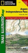
* Trails Illustrated Map for White River, Gunnison & San Isabel National Forests - includes Mt. Elbert
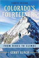
* Colorado's Fourteeners - Gerry Roach's authoritative guide to all the fourteeners in Colorado