Ouzel Falls
| Trail Features: | Waterfalls, Wildflowers | 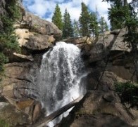 |
|||
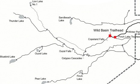
| Trail Location: | Wild Basin Trailhead | ||||
| Roundtrip Length: | 5.4 Miles | ||||
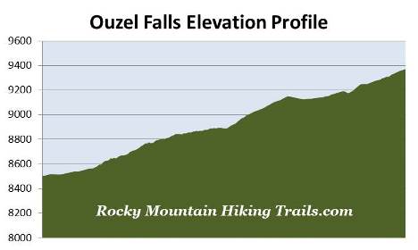
| Trailhead Elevation: | 8500 Feet | ||||
| Total Elevation Gain: | 870 Feet | ||||
| Avg. Elev Gain / Mile: | 322 Feet | ||||
| Highest Elevation: | 9370 Feet | ||||
| Trail Difficulty Rating: | 7.14 (moderate) | ||||
| Parking Lot Latitude | 40.20883 | ||||
| Parking Lot Longitude | -105.56614 | ||||
Trail Description:
 The hike to Ouzel Falls begins from the fairly remote Wild Basin Trailhead in the southeastern corner of Rocky Mountain National Park, located near the small communities of Meeker Park and Allenspark. To reach the trailhead from Estes Park, drive 12.6 miles south on Colorado Highway 7 to the Wild Basin Road junction and turn right. After driving 0.4 miles make another right turn into the park. The Wild Basin Trailhead is located roughly 2.2 miles from the park turn-off on a narrow gravel road, suitable for two-wheel drive vehicles.
This hike offers several attractions along the way, including Copeland Falls and Calypso Cascades. Lower Copeland Falls, your first destination along this route, arrives at just over three-tenths of a mile from the trailhead. The upper falls are located roughly one-tenth of a mile further upstream along the North St. Vrain Creek. There's a side trail that visits both the lower and upper falls. This trail parallels the main trail, and once you've visited Upper Copeland Falls, will allow you to return back to the main trail without having to backtrack.
Beyond the falls the trail crosses over Sandbeach Creek. At just over 1.3 miles from the trailhead you'll reach a spur trail that provides access to a series of five backcountry campgrounds that offer a total of seven individual campsites. To continue towards Calypso Cascades, hikers should stay to the left at this junction.
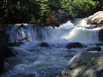
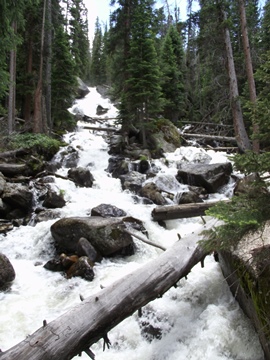
At roughly 1.6 miles hikers will pass an unnamed waterfall, which shouldn't be confused with Calypso Cascades, which is still another two-tenths of a mile further up the trail. Unfortunately, the 200-foot high Calypso Cascades weren't all that impressive during our first visit to these falls on an early-September hike. However, during the spring run-off, the falls are usually roaring, as seen in this photo from a more recent hike in late June (below, on the left).
Above Calypso Cascades you'll begin to catch sporadic views of the surrounding mountains, including Longs Peak and Mt. Meeker towards the north.
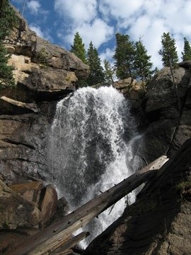
At 2.7 miles hikers will reach Ouzel Falls, which is a very impressive 40-foot waterfall (photo above, on the right). Although you can see it from the new footbridge that now spans across Ouzel Creek, you can get a much better view by traveling off trail for a short distance. Before the 2013 flood, which destroyed the existing footbridge at that time, there used to be an unmarked side trail that led to a much better vantage point. However, it appears that the flood has changed the topography in this area, and it's now a bit of a bushwhack to reach the best viewpoint for this waterfall. At this point it's not clear as to whether the park plans to clear the dead trees from this area. Either way, it's still one of the best waterfall hikes in Rocky Mountain National Park.
Ouzel Falls, Ouzel Creek and Ouzel Lake (2.25 miles further up the trail) are all named after the water ouzel. These small, slate-grey colored birds, also known as American dippers, are known for bobbing, or "dipping", along the rocks around fast moving streams, and diving under water in search of food. Once below the surface of the water the dippers forage by either walking along the stream bottom, or by "flying" through the water, using their wings to propel themselves through the swift currents.
If you wish to extend your hike to visit the most scenic feature on this trail, you will have the option of continuing on to the stunningly beautiful Bluebird Lake. This option, however, would add another 7.2 miles to your roundtrip hike, making this a fairly strenuous hike. Ouzel Lake and Thunder Lake are also great options from this point as well.