Quandary Peak
| Trail Features: | Outstanding views | 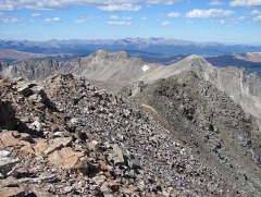 |
|||
| Trail Location: | Hoosier Pass | ||||
| Roundtrip Length: | 6.75 Miles | ||||
| Trailhead Elevation: | 10,850 Feet | ||||
| Total Elevation Gain: | 3450 Feet | ||||
| Avg. Elev Gain / Mile: | 1022 Feet | ||||
| Highest Elevation: | 14,265 Feet | ||||
| Trail Difficulty Rating: | 13.65 (strenuous) | ||||
| Parking Lot Latitude | 39.385162 | ||||
| Parking Lot Longitude | -106.061836 | ||||
Trail Description:
The standard route to the summit of Quandary Peak begins from the Quandary Trailhead, located just north of Hoosier Pass. To reach the trailhead drive 8 miles south on Colorado 9 from Breckenridge, or 14 miles north from Fairplay, and turn west onto Blue Lakes 850 Road. Drive a few hundred yards and turn right onto McCullough Gulch 851 Road, and then drive another tenth-of-a-mile to the small parking area near the trailhead.
Hikers should note that access to the trailhead during the summer months is now available only through a parking reservation, or by shuttle from Breckenridge. You can visit hikequandary.com to book a shuttle or parking reservation.
Quandary Peak is located in the White River National Forest, and is the only fourteener in the Tenmile Range. At 14,265 feet Quandary ranks as the 13th highest peak in Colorado. According to 14ers.com the peak's name comes from a group of miners who were unable to identify a mineral sample found along its slopes in the 1860s. The group was in a "quandary" over the exact nature of the mineral, and ended up naming the mountain from where it originated.
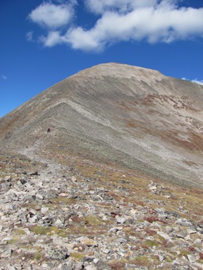
The hike begins on a dirt footpath that ascends along a fairly easy grade. After walking roughly 1.3 miles you’ll emerge above the treeline. Although this is a relatively short hike, and has less elevation gain when compared to many other fourteeners, the trail still packs a punch. Much of the climbing occurs in two relatively short sections. The first section begins just above the treeline. Over the course of the next nine-tenths of a mile hikers will climb roughly 1300 feet to ascend the East Ridge. The second major climb arrives after walking across this relatively flat ridge.
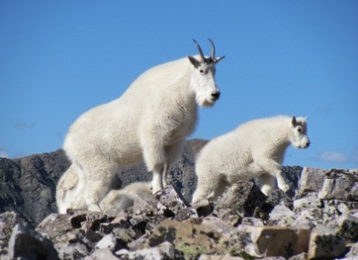 On our most recent ascent we came face to face with a family of mountain goats. We first saw them from a distance meandering around the pathway several hundred feet up-trail. This was near the saddle, just below the upper East Ridge, at roughly 13,000 feet. As we got closer, however, the goats refused to move. In fact, the largest billy (male goat) decided to lay down on the trail just before we were close enough to look into his eyes.
You could say that we were "in a quandary" as to what to do next. We were just about to go off-trail and walk around the road block when we noticed a group of hikers approaching from below. The sight of their dog persuaded the goats to begin moving. Although they were walking, they remained on the trail and didn't allow us to pass. This went on for several minutes until another group of hikers approached from above, which prompted the goats to move off the trail. We were finally able to pass safely, and got about a quarter-of-a-mile away from the goats when we decided to take a quick break. Since we were on a fairly narrow ridge we were only a few yards off to the side of the trail at this point.
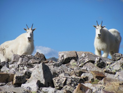 After resting on a large rock for several minutes we noticed the goats were moving again. The large male, the same billy that blocked our progress earlier, was making a direct bee line toward us. I told my wife to get moving as quickly as possible. She was already proceeding up the trail before I was able to get my backpack together. I hurriedly moved out just as the goat got to within 75 feet of my location. It was the last time we saw them.
Coincidentally, just weeks after that encounter, a hiker was fatally gored by a mountain goat in Olympic National Park. The man was hiking with his wife and a friend when they stopped for lunch at an overlook. A mountain goat suddenly appeared and began acting aggressively. After chasing the man for a bit the billy gored him in the thigh, then stood over him as he lay bleeding to death, staring at anyone who tried to help.
After reading the details of the incident, I couldn't help but relate this to my own experience on Quandary Peak. Afterwards, park officials at Olympic began warning hikers not to urinate on or near trails because goats are attracted to the salt. On their website they state: "Stay at least 150' from all wildlife. If a goat approaches, be prepared to chase it off by yelling, waving coats or throwing rocks. Goats crave salts. Urinate on rocks or snow at least 150' from the trail. Do not leave sweaty clothes unattended."
 Was this the reason why the mountain goat so brazenly approached my wife and I as we rested on that rock? Looking back now, I would say the answer to that is likely.
Without any other incidents we continued the stiff climb towards the summit. This route is ranked as being easy on good trail, with exposure to dangerous drop-offs being rated as mild. However, as mentioned already, this final section of trail climbs roughly 1100 feet over the final eight-tenths of a mile to reach the top, making this a very strenuous segment. Moreover, this stretch travels over some very rugged and rocky terrain.
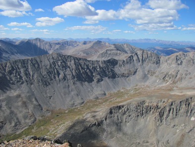
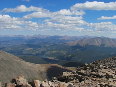
From the summit hikers will enjoy outstanding views of several nearby fourteeners, including Mt. Bross, Mt. Lincoln, Mt. Cameron and Mt. Democrat to the south. Looking towards the north you'll be able to see Pacific Peak and Crystal Peak, as well as the Gore Range in the far off distance.
Although this is a relatively easy climb along a straightforward route with virtually no exposure to dangerous drop-offs, Quandary Peak is still considered to be the most dangerous mountain in Colorado. According to Mark Scott-Nash, author of Colorado 14er Disasters, Quandary Peak has one of the highest accident rates for any fourteener in Colorado, which is likely the result of its popularity, easy year-round access, as well as the variety of routes to its summit. In other words, many of those who get in trouble on this mountain are likely underrating the risks associated with climbing it.
Hikers should always be aware of lightning risk while hiking in the Rocky Mountains, especially at higher elevations. As a general rule of thumb you should plan to be off the summit before noon in order to avoid the notorious afternoon thunderstorms that frequent the mountains in the summer. Hikers should also be prepared for a variety of weather conditions while on the trail. Make sure you have the proper gear with you, and know what safety precautions to consider beforehand.
After your hike you may want to consider stopping in the town of Fairplay. It's an absolute hidden gem. Although it plays up on its association with the popular South Park animated sitcom, it's really a small, laid-back rustic town, with an old west vibe.
Speaking of South Park, the drive though this region is extremely beautiful. There are two main roads that pass through this high elevation grassland basin; one takes you from Buena Vista to Denver (U.S. 285), while the other travels from Buena Vista to Colorado Springs (U.S. 24). In 2009 South Park was designated as a National Heritage Area.
Additional Resources:
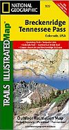
* Trails Illustrated Map for Pike, San Isabel and Arapaho Nat'l Forests - includes Quandary Peak
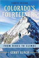
* Colorado's Fourteeners - Gerry Roach's authoritative guide to all the fourteeners in Colorado