
Red Mountain Number 3
| Trail Features: | Outstanding Views, Fall Aspens, History | 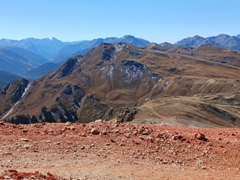 |
|||
| Trail Location: | Red Mountain Pass | ||||
| Roundtrip Length: | 5.8 Miles | ||||
| Trailhead Elevation: | 11,071 Feet | ||||
| Total Elevation Gain: | 1835 Feet | ||||
| Avg. Elev Gain / Mile: | 633 Feet | ||||
| Highest Elevation: | 12,890 Feet | ||||
| Trail Difficulty Rating: | 9.47 (moderate) | ||||
| Parking Lot Latitude | 37.89606 | ||||
| Parking Lot Longitude | – 107.71357 | ||||
Trail Description:
The hike to Red Mountain Number 3 begins just south of Red Mountain Pass, located roughly halfway between Ouray and Silverton. Parking for low-clearance vehicles is available at an unmarked trailhead, located roughly one-tenth of a mile south of the pass. The parking area is actually situated between two roads that branch east off Highway 550 near mile marker 80. The hike begins on the lower or more southern road, which is referred to as County Road 14 on many maps. Google Maps refers to this road as FSR 825. There’s room for 3 or 4 vehicles here. You’ll also have the option of parking at the Black Bear Pass Trailhead, located almost directly across the highway, or at Red Mountain Pass, but use caution while walking along the highway. For those in high-clearance vehicles, you’ll have the option of parking in various places along CR 14, if you wish to shorten your hike.
From the parking area, near mile marker 80, head east on CR 14. After walking roughly one-tenth of a mile the road will split. You should turn right at this junction, and begin heading towards the south.
At roughly four-tenths of a mile the road begins to ascend the southern slopes of Carbon Knob. At just over six-tenths of a mile you’ll pass an unmarked private road that branches off to the left. You should stay to the right to continue along the main road.
At just over eight-tenths of a mile you’ll reach another split in the road. Country Road 14 continues towards the right. Hikers should proceed through the locked gate and onto the road straight ahead, which is known as Red Mountain Three Road. Although there’s a sign on the gate that states this is private property, it also states that hikers, skiers, and cyclists are welcome. If you have a high-clearance vehicle, there’s room for maybe 2 or 3 cars near this gate, but don’t block it.
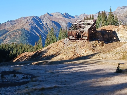
During the early portions of the hike you’ll pass the remnants and signs of past and current mining operations. Shortly after passing through the gate, Red Mountain Three Road will travel through the old Congress and Carbon Lake mines.
At roughly 1.3 miles, just above a couple of old dilapidated buildings, hikers will reach an unmarked split in the road. You should stay to the left at this junction to continue along Red Mountain Three Road. A short distance above this split you’ll arrive at another locked gate. You’ll also see a sign on the railing stating that hikers and skiers are welcome. Simply pass through this gate and continue up the road.
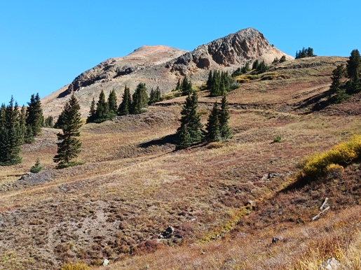
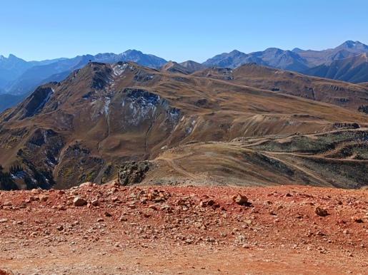
Shortly after passing through the gate you’ll begin enjoying outstanding views of the mountains to the north of Red Mountain Pass. Your destination will also come into view at this point. Looking towards the east-northeast, you’ll likely notice two mountains dominating the view (see photo below). The higher peak on the left, with a communication tower, is Red Mountain #3. The road, however, traverses around the unnamed mountain (or prominence) on the right before approaching Red Mountain #3 from the back side.
As you continue higher the views become progressively more expansive. At 1.9 miles you may notice a single track trail branching off to the right. Simply ignore this and continue along the road.
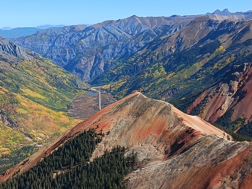
As you climb towards the summit the terrain steepens, quite sharply I should add. At just over 2.6 miles you’ll get a short reprieve from the relentless climbing. Though it’s very short, your destination is now in sight. From here you’ll begin the last pitch to the top, while passing a communication tower along the way.
At 2.9 miles hikers will finally reach the top of the mountain. From the summit you’ll enjoy incredibly spectacular views, including almost the entire valley north of Red Mountain Pass. The highlights from the summit, which rises to 12,890 feet, and is the highest among the three “Reds,” are the views of 12,208-foot Red Mountain Number 2 and 12,572-foot Red Mountain Number 1. The brilliant red, crimson and vermilion colors in these mountains look like something you might find on Mars. Though definitely not from another planet, the peaks received their names as a result the reddish iron ore found on the surface of the mountains.
Strangely, the top of the mountain is one large flat spot. It seems likely that it was flattened at some point when mining operations were active in this area.
The entire route travels along jeep roads. There’s virtually no exposure to any steep drop-offs along the way. However, you will be exposed to the sun and weather during the entire trip. There are a few private side roads along the route, so you may want to have a good trail map with you. Also, make sure you’re fully acclimated to elevation before attempting this hike.
Additional Resources:
* Trails Illustrated Map for Telluride, Silverton, Ouray and Lake City areas