Ute Trail
| Trail Features: | Outstanding Views, Alpine Tundra | 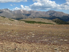 |
|||
| Trail Location: | Ute Crossing | ||||
| Roundtrip Length: | 4.0 Miles | ||||
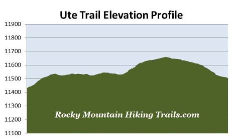
| Trailhead Elevation: | 11,430 Feet | ||||
| Total Elevation Gain: | 405 Feet | ||||
| Avg. Elev Gain / Mile: | 203 Feet | ||||
| Highest Elevation: | 11,660 Feet | ||||
| Trail Difficulty Rating: | 4.81 (easy) | ||||
| Parking Lot Latitude | 40.39333 | ||||
| Parking Lot Longitude | -105.69537 | ||||
Trail Description:
Never doubt the old adage that weather in the Rocky Mountains can change quickly….
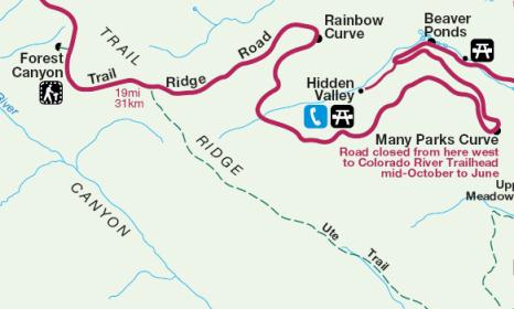
Trying to figure out where the Ute Trail is located can be a little confusing. One section runs from the Alpine Visitor Center at Fall River Pass down to Milner Pass near Poudre Lake. The other section, detailed here, begins from the Ute Crossing Trailhead located roughly 9.9 miles west of Deer Ridge Junction (Highways 34 and 36) on Trail Ridge Road (or 2 miles west of Rainbow Curve). This hike begins from a small parking area with enough room for roughly eight or nine vehicles (there's another small parking area located about a quarter-of-a-mile further up the road). With the exception of an historical information kiosk, the trailhead is unmarked.
The kiosk explains that the trail was used by Arapaho and Ute Indians on their journeys between winter and summer hunting grounds on the Great Plains. According to Rocky Mountain National Park: A History, Native Americans likely traveled across the national park using several east-west routes, including Forest Canyon, Flattop Mountain, Fall River and this route, known as Trail Ridge.
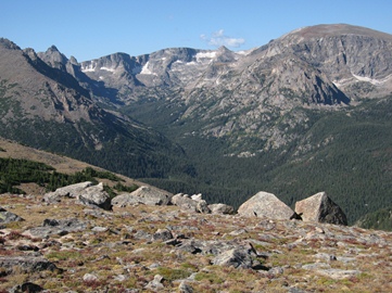 The Ute Trail offers hikers expansive views and alpine tundra scenery without having to do a lot of climbing. Trekking entirely above treeline will also allow you to enjoy panoramic views along the entire route. Though mostly flat, the hike does include two short climbs as you cross Tombstone Ridge; the first begins just beyond the trailhead, while the second begins at roughly the one-mile mark. At these lofty heights hikers should expect a lot of sun and wind, as well as the possibility of an afternoon thunderstorm.
Alpine tundra begins where trees cannot survive the extremes of snow, cold, strong winds and a short growing season. In Rocky Mountain National Park this zone roughly begins at elevations between 11,000 and 11,500 feet, depending on exposure to the sun.
Much of the alpine tundra in Rocky Mountain National Park is covered with dense turfs of sedges and grasses that support various animals. The rich soils of the tundra also support a variety of wildflowers, including the alpine sunflower, which only grows in the Rocky Mountains. Only a few animals, such as pikas, ptarmigans and marmots, live year-round at these elevations. Others, such as ravens, hawks, coyotes and elk, will migrate onto the tundra during the summer months.
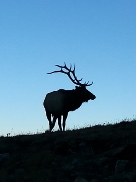

On our most recent hike we passed a herd of elk near the trailhead, and then another at roughly the half-way point. Both herds, numbering roughly 20 in size, were a good quarter-of-a-mile off the trail. You should also keep an eye out for bighorn sheep, and the possibility of spotting a rare, non-native mountain goat.
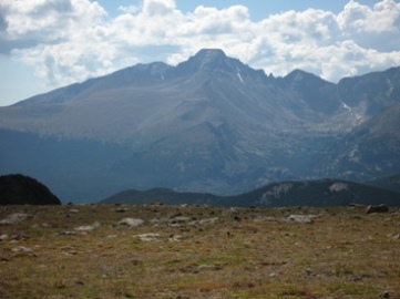 After climbing the second rise the trail tops out at roughly 11,660 feet, and then begins to gradually drift downhill for the remaining portions of the route. From this point forward you'll enjoy commanding views of Longs Peak towards the south, the highest mountain in the park. On your right, looking towards the southwest is Forest Canyon and the Big Thompson River. Eventually you'll notice a large rock outcropping almost directly ahead of you, just off to the side of the trail. Known as Timberline Pass, this spot also marks the final destination for this hike.
At roughly two miles from the trailhead you'll finally reach Timberline Pass. Most hikers opt to end their hike here. From this spot you'll enjoy outstanding panoramic views of Longs Peak, Moraine Park and Estes Park. Beyond the pass the trail makes a steep descent through Windy Gulch as it makes its way towards Beaver Meadows in Moraine Park.
In the fall of 2012 a wildfire scorched 3500 acres just south of Timberline Pass and Windy Gulch. It's believed the fire was sparked by an illegal campfire on October 9th. Although it was a low intensity fire, and remained under control for the most part, it still forced the closure of almost all the trails in the Moraine Park and Bear Lake Road areas for several weeks. That all changed on November 30th when a fierce wind storm brought 70 mph gusts that pushed the fire 3 miles in just 35 minutes, and more than doubled its size as it raced across Moraine Park. At its peak more than 600 fire fighters were assigned to the blaze. The fire wasn't fully extinguished until heavy snow arrived in mid-December. The Fern Lake Fire is now one of the largest wildfires in Rocky Mountain National Park history.
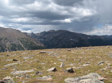
Our first hike along this trail started out under beautiful cobalt blue skies. As the day progressed, however, clouds started building. At the turnaround point the clouds began to darken a little, and by the time we were half-way back to the trailhead the clouds were looking downright threatening. I thought for sure we were going to make it back to our car before the rain would start. Our luck, unfortunately, didn't quite hold out. It started to drizzle, then sleet, and then we started getting pelted by small pea-sized hail. When the wind started whipping up, faces and exposed legs began stinging!